Location: Bam, Kerman Province Map
Active: 500 BC-1850 AD
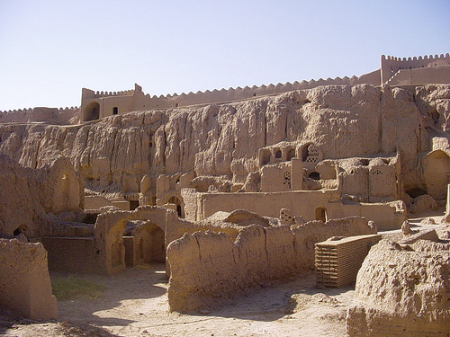
The Arg-é Bam (Bam Citadel), located in the city of Bam in Kerman Province, southeastern Iran, is a monumental adobe fortress and one of the most significant cultural and historical landmarks in the world. Recognized as a UNESCO World Heritage Site in 2004 under the designation “Bam and its Cultural Landscape,” it is celebrated as the largest adobe structure globally, showcasing ancient Persian engineering and architecture. The citadel, with origins tracing back to the Achaemenid Empire (6th–4th centuries BC), served as a thriving hub on the Silk Road and other trade routes, particularly from the 7th to 11th centuries. Despite its near-total destruction in a devastating earthquake in 2003, ongoing restoration efforts have revived much of its grandeur, making it a symbol of resilience and cultural heritage.
The Arg-é Bam’s history spans over two millennia, reflecting the
evolution of Persian civilization through multiple dynasties and
cultural shifts. While precise archaeological dating of its structures
is lacking, historical sources suggest its origins date to the
Achaemenid period (579–323 BC), with some features resembling the
architectural model of Persepolis, such as its elevated platform
combining natural and man-made elements.
Parthian Era (248 BC–224
AD): The fort was expanded into a full citadel, named Arg-é Bam, meaning
“Citadel of Bam.” The core of the city and the governor’s section were
likely established during this period, as concluded in the study “Bam
and a Brief History of Urban Settlement and Planning in Iran.”
Sassanid Era (224–637 AD): The citadel was captured by Ardeshir I,
founder of the Sassanid Empire, who constructed new fortifications and
walls. It became a strategic stronghold.
Islamic Conquest (645–656
AD): The Kerman region, including Bam, was conquered by Arab forces,
likely causing damage to the citadel. An Arab commander established the
Al Rasoul mosque, one of Iran’s earliest mosques. The Khawarij, a
defeated Muslim sect, settled in the citadel in 656 AD.
Saffarid and
Later Periods (869 AD onward): Ya’qub ibn al-Layth al-Saffar made Arg-é
Bam his permanent base after defeating the Khawarij. By the 10th
century, Islamic writers described Bam as a bustling marketplace with
elegant cotton fabrics, an impregnable fortress, busy bazaars, and palm
trees, thriving due to its position on the Silk Road and spice routes.
Mongol and Qarakhataian Rule (1240–1363 AD): Bam prospered as a silk
production center under the Qarakhataian dynasty, benefiting from its
strategic trade location.
Safavid Era (1502–1722): A period of
relative stability saw significant development, including the
construction of the Four Seasons Palace (Chahar Fasl). The citadel was a
flourishing urban center.
Qajar Era (1789–1925): The citadel was
militarized by Agha Mohammad Khan Qajar to counter Afghan and Baluchi
incursions. In 1839, Aga Khan I, leader of the Nizari Ismaili sect, took
refuge here during a rebellion but was arrested. By 1880, only military
personnel remained, and the civilian population began settling outside
the citadel.
Modern Era: By 1900, the new city of Bam developed, and
the citadel was used as a garrison until 1932, after which it was
abandoned. Recognized as a national historic site in 1953, conservation
began in earnest from 1973, managed by Iran’s Cultural Heritage
Organization (ICHO).
The citadel remained inhabited until around
1850, with its abandonment possibly linked to declining strategic
importance and invasions, such as the Afghan attack in 1722.
The Arg-é Bam is a fortified medieval town covering approximately
180,000 square meters (1,937,503 sq. ft.), built primarily with
adobe (non-baked clay bricks, or khesht) and mud layers (chineh), a
vernacular technique that exemplifies sustainable desert
architecture. The citadel is situated on an artificial hill,
elevated 5 meters above the surrounding city, combining a natural
hilltop and man-made terrace for strategic visibility and defense.
Its rectangular layout, measuring 315 meters east-west and 270
meters north-south, is surrounded by formidable defensive
structures.
Key Architectural Features:
Defensive
Structures:
Walls: The citadel is enclosed by four concentric
defensive walls, with the outermost wall, 6–7 meters high and 1,815
meters long, encircling the old city and citadel. It features 38
watchtowers spaced every 30–40 meters, with two prominent towers
enhancing its iconic silhouette.
Moat: A 5-meter-deep trench
surrounded the citadel, enhancing its impenetrability.
Gateways:
The primary access today is the southern gateway, near a park
established by Bam municipality. Historically, the citadel had
limited entry points, ensuring security.
Urban Layout:
The
citadel was a self-sufficient city divided into two main sectors:
the governor’s section and the peasantry section.
Governor’s
Section: Located at the highest point for security, it included:
The Governor’s Mansion, a two-story structure with summer and winter
wings, an iwan, and a prison/dungeon beneath. Renovated during the
Safavid period, it is one of the oldest structures.
The Four
Seasons Palace (Chahar Fasl), a square, domed building possibly of
pre-Islamic Zoroastrian origin, rebuilt in the Safavid era. Its
basement, with larger bricks, suggests an older foundation.
Military facilities, including barracks, an armory, a 40-meter-deep
water well, and stables for 200 horses.
Peasantry Section: The
working-class neighborhood (rabaz) included:
Housing: Three types
of homes: small 2–3-room houses for the poor, larger 3–4-room houses
with verandas for the middle class, and luxurious homes with
courtyards and seasonal rooms for the elite.
Public Amenities: A
bazaar, mosque (Al Rasoul), school, workshops, and stables supported
a vibrant community.
The citadel’s design ensured autarky, with
water from qanats (underground irrigation canals), gardens,
livestock, and domestic animals.
Construction Techniques:
The chineh technique involved layering mud, while khesht used
sun-dried mud bricks, sometimes reinforced with straw or palm
timbers.
The architecture was planned holistically, with each
phase enhancing the overall form, allowing seamless additions
without disrupting the existing structure.
Date palm logs were
occasionally embedded to stabilize walls, though timber was scarce
in the desert environment.
Qanats: The citadel’s survival in the
desert relied on an intricate network of qanats, some of the
earliest preserved in Iran, which irrigated agricultural lands and
supported the oasis town.
The citadel’s strategic location near
the Rud-e Posht river, steep cliffs, and surrounding gardens
optimized both defense and self-sufficiency. Its architecture
reflects a blend of Achaemenid, Sassanid, Islamic, Safavid, and
Qajar influences, making it a historical museum of Persian design.
The Arg-é Bam was a vital hub on the Silk Road, connecting Central
Asia, the Persian Gulf, India, and Europe. Its strategic position made
it a crossroads for trade in spices, silk, and cotton, fostering
cultural exchange and economic prosperity.
Economic Role: Bam was
renowned for silk and cotton garment production, with textiles exported
to Khorasan, Iraq, and Egypt. The 10th-century geographer Ibn Hawqal
noted the high quality and durability of Bam’s cotton cloths, valued at
30 dinars each. Silkworm breeding and a flourishing silk industry
further boosted the economy.
Cultural Exchange: As a trade nexus, Bam
facilitated interactions among diverse cultures, influencing its
architecture, textiles, and social systems. The Al Rasoul mosque and
potential Zoroastrian elements in the Chahar Fasl highlight its
religious diversity.
Legendary Status: The citadel features in
Persian literature, notably in Ferdowsi’s Shahnameh, which recounts the
conquest of King Ardashir I. A legend attributes the name “Bam” (meaning
“burst”) to a worm that brought prosperity to a local king, burst by
Ardashir’s conquest.
The citadel’s oasis environment, sustained by
qanats, exemplified human adaptation to the desert, creating a
sustainable urban ecosystem.
On December 26, 2003, a 6.6-magnitude earthquake struck Bam at 5:26
AM local time, with its hypocenter just 7 km beneath the city,
amplifying its destructiveness. The disaster killed 26,271–32,000
people, injured 30,000, and destroyed 70–80% of Bam, including 80–99% of
the Arg-é Bam.
Structural Damage: The adobe structures,
unmaintained for over 80 years, were highly vulnerable. Erosion, termite
damage, and prior renovations that ignored seismic risks exacerbated the
collapse. Newly restored sections often suffered more damage than
unrestored ones, highlighting flaws in modern interventions.
Misconceptions: While mud buildings were blamed for the devastation,
only one-third of deaths occurred in adobe structures; many modern
concrete and steel buildings also collapsed due to poor construction
quality.
Unique Seismic Effects: The Bam Fault, 3 km east of the
citadel, channeled earthquake energy in an east-west direction,
perpendicular to the north-south-oriented fault, amplifying damage to
buildings with north-south axes, including parts of the citadel.
The
earthquake exposed the fragility of earthen architecture in seismic
zones but also underscored its potential resilience when properly
maintained.
Following the earthquake, Iranian President Mohammad Khatami
announced the citadel’s rebuilding, sparking a global restoration
effort. By 2013, 99% of the “save Bam” project was complete, and the
citadel was reopened to visitors.
International Collaboration:
Japan: Provided $1.3 million and 3D modeling for reconstruction.
Italy: Contributed $300,000 and sent experts to restore the main tower.
France: Supplied archaeological surveys and maps.
World Bank:
Allocated significant funds.
UNESCO Guidelines: Parts of the damaged
landscape were preserved to acknowledge the earthquake as a historical
event, balancing restoration with authenticity.
Challenges: Modern
bricks often lack the quality of ancient adobe, and some restorations
have been criticized for compromising historical integrity.
Today,
the citadel is a blend of restored structures and preserved ruins,
offering a glimpse into its past while acknowledging its modern rebirth.
The Arg-é Bam remains a major tourist attraction, drawing visitors
for its historical significance and striking desert setting. Reviews on
Tripadvisor describe it as “magnificent,” “nostalgic,” and “romantic,”
especially at sunset when the adobe walls glow in warm hues.
Accessibility: The citadel is accessible via the southern gateway,
reached from Kerman (193 km away) by shared taxi or private transport.
Visitors are advised to arrive in the afternoon for optimal lighting.
Features: Restored sections include the governor’s mansion, Four Seasons
Palace, and parts of the bazaar and mosque. Some areas remain in ruins,
offering a poignant contrast between past glory and modern restoration.
Visitor Tips: Social distancing and masks may be required due to ongoing
health protocols. Sunset visits are recommended for dramatic views, and
some restricted areas may be accessible with permission from security
personnel.
The citadel’s partial restoration enhances its allure,
allowing visitors to witness both its ancient grandeur and the ongoing
efforts to preserve it.
The Arg-é Bam stands as a testament to Persian architectural
ingenuity, environmental adaptation, and cultural resilience. Its adobe
construction, qanat system, and strategic design reflect sustainable
urban planning in a harsh desert environment. As a Silk Road hub, it
embodies centuries of economic and cultural exchange, while its survival
through invasions and its rebirth after the 2003 earthquake highlight
its enduring legacy.
UNESCO Recognition: Inscribed in 2004 and
placed on the World Heritage in Danger List post-earthquake, it
underscores global commitment to its preservation.
Symbol of
Resilience: The citadel’s restoration, likened to a “Phoenix rising,”
symbolizes Iran’s dedication to its heritage.
Cultural Identity: As a
“historical museum” of Persian architecture, it showcases Achaemenid,
Sassanid, Islamic, and later influences, making it a vital link to
Iran’s past.