Location: 53 km South- West of Jerusalem Map
Eleutheropolis, known as the "Free City" (from Greek Ἐλευθερόπολις), was a significant Roman and Byzantine city in the region of Syria Palaestina, located approximately 53 km southwest of Jerusalem on the ancient road to Gaza. Its modern location is within the Beit Guvrin-Maresha National Park in Israel, where its ruins straddle the historical landscape. The city’s rich history spans from its Iron Age origins as the Judahite city of Maresha, through its Hellenistic, Roman, Byzantine, and Crusader periods, to its later Islamic and modern iterations as Bayt Jibrin.
Eleutheropolis’ story begins with its
predecessor, Maresha, a Judahite city in the Shephelah (lowlands) of
Judea, mentioned in the Hebrew Bible (Joshua 15:44, 2 Chronicles 14:9).
Maresha flourished during the Iron Age and Hellenistic periods but was
destroyed by the Parthians in 40 BCE, prompting survivors to resettle 2
km north at a site known as Beth Gabra or Beit Guvrin, meaning "house of
strong men" or "house of Gabriel" in Aramaic.
In 64 BCE, Pompey
conquered the region, settling Roman veterans at the site. The pivotal
moment came in 199–200 CE, when Emperor Septimius Severus refounded Beit
Guvrin as a polis, naming it Lucia Septimia Severiana Eleutheropolis and
granting it ius italicum, a privileged legal status conferring Roman
citizenship and tax exemptions. This transformation, marked by the
minting of coins depicting deities like Tyche and Zeus Heliopolitanus,
elevated Eleutheropolis to a major administrative and economic hub.
The city thrived
during the Roman and Byzantine periods, serving as a central point for
measuring distances to other towns, as noted by Eusebius in his
Onomasticon. It was a melting pot of Jews, Christians, and pagans, with
a significant Jewish community, including Talmudic scholars like Judah
b. Jacob and Jonathan of Beit Guvrin. The city was one of Palestine’s
"Cities of Excellence," according to 4th-century historian Ammianus
Marcellinus.
Eleutheropolis faced destruction in 796 CE
during Muslim civil wars. The Crusaders rebuilt it in 1134 as
Bethgibelin, erecting a fortress under Fulco of Anjou, entrusted to the
Knights of St. John. They restored a Byzantine church at nearby Tell
Sandahannah (ancient Maresha). The city changed hands multiple times:
captured by Saladin in 1187, reconquered by Richard the Lionheart in
1191, destroyed by Mamluk Sultan Bibars in 1264, and rebuilt by the
Ottomans in 1551.
By the 19th century, Bayt Jibrin was a modest
village with about 1,000 Muslim inhabitants, known for its Crusader
fortress and fertile lands. During the 1948 Arab-Israeli War, its Arab
population was displaced, and the site was incorporated into the modern
Beit Guvrin kibbutz and national park.
Eleutheropolis was a cultural and religious
crossroads. Its Jewish heritage is evident from its Talmudic prominence
and the presence of scholars. Rabbi Judah the Prince, in the late 2nd
century CE, exempted the city from tithing and Sabbatical Year
obligations, suggesting it was not settled by Jews returning from
Babylonian captivity.
Christianity took root
early, with Eleutheropolis becoming an episcopal see in 325 CE under
Bishop Macrinus, who attended the Council of Nicaea. The city was home
to notable Christian figures, including Eusebius of Caesarea and
Epiphanius of Salamis, born nearby. In 638 CE, 50 Christian soldiers
from Gaza’s garrison were martyred here for refusing to convert to
Islam, and a church was built in their honor. The city was also a
monastic center until the Arab conquests.
Pagan influences
persisted in the Roman period, as seen in coin iconography and the
city’s amphitheater, used for gladiatorial contests and executions. With
Christianity’s rise, the amphitheater was repurposed as a marketplace.
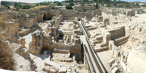
The ruins of Eleutheropolis, now part of Beit
Guvrin-Maresha National Park, are extensive and reveal a prosperous
city. Key features include:
Bell Caves: Large, bell-shaped
quarries from the Roman period, carved into soft chalk, used for
extracting building materials. These interconnected caves, some 60 feet
high, are lit by circular apertures and feature arched doorways.
Oval
Amphitheater: A rare oval-shaped structure, unique in Israel until a
similar one was found in Caesarea. It hosted gladiatorial fights and
public executions before becoming a market in the Christian era.
Bathhouse: A massive 4,000 m² Roman bathhouse, indicative of the city’s
wealth and urban sophistication.
Crusader Fortress and Church: The
180-foot-square fortress, built in 1134, includes remnants of a chapel
with groined roofs and clustered columns. The nearby Byzantine church at
Tell Sandahannah, restored by the Crusaders, features fine masonry.
Aqueduct and Water Systems: A Roman-Byzantine aqueduct brought water
from a spring near Hebron, 25 km away, through Wadi el-‘Unqur,
supporting the city’s agriculture and population.
Caves and Grottoes:
The surrounding area is rich in natural and artificial caves, some used
as early Christian worship sites, others bearing Arabic inscriptions.
St. Jerome noted their remarkable nature, linking them to the Idumaean
Horites who dwelt in caves for security and coolness.
Madaba Map
Depiction: The 6th-century Madaba Map shows Eleutheropolis as a walled
city with three towers, a colonnaded street, a basilica, and a domed
building, reflecting its urban grandeur.
The region’s tells (mounds)
and ruins, including those of biblical Maresha at Tell Sandahannah,
highlight its archaeological significance.
Located in Judea’s Shephelah, Eleutheropolis sat on a high hill in a fertile, healthy region, ideal for agriculture. Its strategic position on trade routes connecting Jerusalem to Gaza and Ascalon ensured economic vitality. The valley alongside the ruins, running south-by-east, and the presence of springs and aqueducts supported a robust water supply. The area’s caves provided natural shelters, contributing to its nickname “city of the free” (possibly a play on the Hebrew ḥor, meaning “cave” or “free”).
Today, Eleutheropolis’ remains are preserved
within Beit Guvrin-Maresha National Park, a UNESCO World Heritage Site.
Visitors can explore the bell caves, amphitheater, bathhouse, and
Crusader ruins, alongside tunnels used during the Bar Kochba Revolt
(132–135 CE). The park’s dual focus on Maresha and Eleutheropolis offers
a journey through millennia of history.
The site is accessible
from Jerusalem (a 40-minute drive) and attracts tourists for its
archaeological richness and scenic beauty. Guided tours highlight the
Roman city’s layout, Jewish heritage, and Crusader legacy. The nearby
kibbutz of Beit Guvrin, established in 1949, reflects the area’s modern
Jewish resettlement.
Preserving Eleutheropolis’ ruins is challenging due to natural erosion and urban encroachment. The national park’s management ensures conservation, but some structures, like the Crusader chapel, remain heavily damaged. The 1948 depopulation of Bayt Jibrin and the displacement of its Palestinian residents to camps like Bayt Jibrin (‘Azza) and Fawwar add a layer of historical sensitivity to the site’s modern narrative.