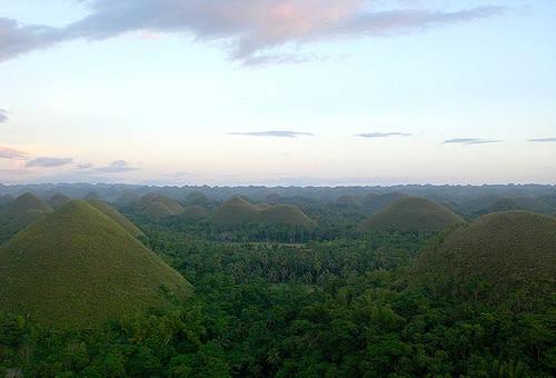
Chocolate Hills in Bohol in are unusual geologic formations that consist of cone like hills covered by tropical jungles of Philippines.
Generally speaking, the Chocolate Hills are an
uneven terrain of grassy hilltops, which are characterized by a
uniform cone or dome-shaped and mostly symmetrical appearance. Their
total number is given as at least 1268, with a total of up to 1776
individual hills of grass-covered limestone. The elevations vary in
height from 30 to 50 m, with the largest crest reaching a height of
around 120 m. Though scattered like molehills across the central
plain of the island, they do accumulate in the areas of Sagbayan and
Batuan parishes, with the largest accumulation occurring near the
village of Carmen.
During the dry season, when the amount of precipitation is
insufficient for the vegetation, the grassy hills dry up, change
their color and take on a chocolate brown tone. Because they remind
of oversized chocolate kisses in these dry periods, they were given
the name Chocolate Hills.
The photographer Salvador Andre provides a particularly accurate
description of this sight:
“Most people who see the pictures of this landscape for the first
time find it difficult to understand that these hills were not
created by human hands. Nevertheless, one quickly gives up this
idea, given the (necessary) workload, which should surely have
exceeded the construction of the pyramids. "
And further:
“There is no natural formation like this anywhere in the world. From
a distance, they look like half balls that seem to have grown out of
the ground. The hills, shaped like molehills and formed almost
uniformly, provide the entire landscape with green and brown dots. ”
The area around the Chocolate Hills is characterized by a relatively
flat to uneven topology, which is characterized by various
elevations, which do not protrude more than 100 to 500 m above sea
level. Overall, the landscape of the interior is dominated by a
series of high karstart hills, which in the village of Carmen are
predominantly shaped by nature.
The vegetation of the Chocolate Hills is determined by hardy
grasses, such as Imperata cylindrica or Saccharum spontaneum, a type
of sugar cane. They also grow various daisy species and ferns,
although the natural vegetation of the hills is now endangered by
quarry work. Between the hills, the lowlands are cultivated with
rice and other crops.
Geologists have long debated the origins of the hills,
with various conjectures raised about the origins of the Chocolate
Hills. Therefore, there are a variety of hypotheses that try to explain
the formation of the hills. The simplest explanations are based on
weathering of the limestone, submarine volcanism and geological uplift
of the lake bed. A more recent theory assumes that an ancient volcano
erupted and spewed out huge blocks of stone, which were then covered
with limestone and later rose from the ocean bed. Some arguments also
add the influence of tidal movements to their explanation of the origin
of the hills.
Another theory suggests that the mounds originated
from ancient limestone coral reefs that were eventually formed over
thousands of years by erosion from both water and wind. Geologists also
believe that the specific shape of the hills is due to the influence of
the weather over millions of years. The upper layers of the limestone
formations were broken off before erosion processes followed and created
the cone-shaped hills that are visible today.
The bronze plaque
placed on the observation deck in Carmen is based on the theory that
they are eroded formations made of a type of marine limestone sitting on
hardened layers of clay.
The board reads:
The unique land form
known as the Chocolate Hills of Bohol was formed ages ago by the uplift
of coral deposits and the action of rain water and erosion.
(eng:
“The unique landscape formation known as the Chocolate Hills of Bohol
was formed anciently by the uplift of coral deposits and the influence
of rainwater and erosion.”)
Furthermore it says:
The grassy
hills were once coral reefs that erupted from the sea in a massive
geologic shift. Wind and water put on the finishing touches over
hundreds of thousands of years.
(English: “The grassy hills were once
coral reefs that rose from the sea through a massive geological shift.
Wind and water gave them the finishing touches over hundreds of
thousands of years.”)
The cone-shaped karst hills that make up
the Chocolate Hills have similarities to the limestone regions of
Slovenia and Croatia, although unlike them they do not have any larger
caves. The karst theory generally states that "changes in sea levels
have raised and, together with terrestrial erosion under the influence
of air, hilly landscape formations are formed from a biogenic reef area,
which are often interspersed with cesspools and small caves." The
Chocolate Hills would therefore be a Example of such a karst topology.
A very similar, largely unknown and much smaller region exists in
San Carlos City, on the island of Negros, and the Osmeña Peak on the
island of Cebu. There is also a similar sediment formation in Purnululu
National Park in Western Australia, which is called the Bungle-Bungle
Massif.
A total of four legends tell of the origins of this
attraction:
The first is about the fight between two giants who threw
stones and sand at each other for days before, tired and exhausted, they
made friends and left the island. The battlefield they left untidy can
now be admired as the Chocolate Hills area.
The second, on the other
hand, is far more romantic. Arogo, a young and strong giant, once fell
in love with Aloya, an ordinary mortal and daughter of a native chief.
When she died, his heart broke and Arogo cried bitterly. His tears
became hills that, as the Chocolate Hills visible today, still bear
witness to his deep sadness.
The third tells of a village that was
plagued by a huge carabao that ate all the plants in the fields of that
town. Finally, when he had had enough, the villagers gathered up all
their spoiled food and placed it in the carabao's path so he couldn't
miss it. After he ate this food as well, his stomach couldn't process
the bad food, so he excreted pile after pile as he continued his journey
until his stomach was empty again. The excretions dried and formed
today's Chocolate Hills.
The last legend talks about a giant named
Dano who ate everything he came across on his way. One day he came to a
plain. Here he saw a beautiful young woman named Eng. To get her
attention, he decided to lose weight and so he eliminated everything he
ate. Eventually his excreta covered the entire country and in the end he
managed to get the attention of his beloved.
Tourism development
Long before the sandy beaches of Panglao Island, the Chocolate Hills
were known as a major tourist destination in Bohol and the entire
Philippines. For this reason, the Chocolate Hills have been designated
as “flagship tourist destinations” by the Philippine government.
Of the 1268 hills, two have been developed into a tourism resort. The
first is located in the municipality of Carmen and belongs to the
barangay Buenos Aires just a few minutes from the village center. The
younger of the two is called Sagbayan Peak and is part of the town of
Sagbayan.
The observation station in Carmen, about 55 km from
Tagbilaran City and about 5 km from Carmen town center, is designated as
government property and houses a managed facility called the Chocolate
Hills Complex.
The Chocolate Hills Complex has a restaurant, a
hostel with a swimming pool and an observation deck that offers a view
of the surrounding area covered with hills at a height of 210 m. A total
of 214 steps lead to the viewing area, which was built on one of the
conical hills and allows a 360° panoramic view of the surrounding area.
The entire Chocolate Hills Complex was embedded in a total of two of the
hills.
The second opportunity to take a look at the Chocolate
Hills is at Sagbayan Peak, a mountainous resort in the town of Sagbayan
about 75 km northwest of Tagbilaran City and 18 km from Carmen. Here, a
platform on an elevated ridge allows an unobstructed view of the
Chocolate Hills. When the weather is clear you can even see across the
sea to Cebu City from here.
The National Committee of Geology declared the
Chocolate Hills of Bohol a National Geological Monument on June 18,
1988, recognizing the special characteristics, scientific significance,
uniqueness and high scientific value of the landscape formation. As
such, the Chocolate Hills are also designated as a protected landscape
area in the country. With Proclamation No. 1037 signed by President
Fidel Ramos on July 1, 1997, the hills and the area surrounding them in
the municipalities of Carmen, Batuan and Sagbayan, Bilar, Valencia and
Sierra Bullones were declared a National Monument, designated as a
natural beauty spot must be protected and preserved. This means they
fall under the National Integrated Protected Areas System (NIPAS)
(regulations for nationally integrated protected areas). In the area of
the Rajah Sikatuna Protected Landscape National Park, the original
vegetation on the limestone cones has been preserved.
On May 16,
2006, the Department of Environment and Natural Resources (DENR)
submitted the Chocolate Hills to UNESCO for inclusion on the World
Heritage List. Because of their outstanding universal value, they would
fall under the seventh criterion, which deems “outstanding natural
phenomena or areas of outstanding natural beauty and aesthetic
importance” worthy.
As a result, all mining activities and quarry
work within the three towns of Sagbayan, Batuan and Carmen were banned
by the provincial governor of Bohol in order to ensure the long-term
protection of the area.