Location: Tyrol Map
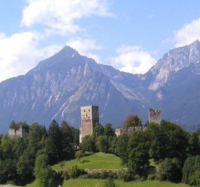
Burgruine Kropfsberg, also known as Kropfsberg Castle or Burg Kropfsberg, is a medieval hilltop castle ruin located in the municipality of Reith im Alpbachtal in the Alpbachtal valley, Tyrol, Austria. Perched on a towering ridge at 526 meters (1,726 ft) above sea level in the Inn Valley, it overlooks the village of St. Gertraudi and serves as a border fortress remnant from the Prince-Archbishopric of Salzburg's era. Coordinates are approximately 47°24′26″N 11°50′48″E. The castle is unique in Tyrol for its three nearly equal-height towers and represents one of the largest castle complexes in the region, covering about 26,000 m². Today, it stands as a preserved historical monument amid scenic alpine landscapes, appealing to history buffs and outdoor enthusiasts exploring the Zillertal entrance, though it remains a lesser-visited site compared to more prominent Tyrolean attractions.
Kropfsberg Castle's origins trace back to the early 12th century,
when large portions of the Zillertal valley belonged to the
Prince-Archbishopric of Salzburg. Archbishop Konrad I of Salzburg
commissioned the initial construction around 1147 as a border fortress
to protect ecclesiastical possessions at the Zillertal entrance, likely
starting as a simple central tower surrounded by walls. It served as the
seat of the Salzburg court and administration, with castellans and
keepers managing it. The castle was first documented in 1286 (or 1296 in
some sources). Archbishop Eberhard II von Regensberg expanded it
significantly in the late 13th century, adding the main castle with two
mighty keeps above the original tower, shaping its Romanesque core.
In the 15th century, the castle hosted pivotal negotiations: in 1412, it
settled a dispute between Tyrol and Bavaria at the Imperial Diet, and in
1416, it facilitated reconciliation between Duke Frederick IV of Austria
and his brother Duke Ernest of Inner Austria, securing Frederick's hold
on Tyrol. Around 1500, Archbishop Leonhard von Keutschach rebuilt and
fortified it, adding residential floors with large windows. By 1540, a
massive loop-shaped enceinte (900 m long, 8 m high, 3 m thick) and
semicircular bastions were constructed, making it one of Tyrol's largest
castles, protected by a double ring wall and accommodating 60-80 people.
This expansion symbolized sovereign power.
The court seat relocated
to Zell am Ziller in 1592, initiating decline; buildings collapsed by
1673 due to neglect. In 1703, during the Bavarian Rummel (part of the
War of the Spanish Succession), Bavarian soldiers occupied it but were
expelled by Tyrolean shooters. In 1809, amid Napoleonic Wars, Tyrol
ceded to Bavaria under the Treaty of Schönbrunn, and the ruined castle
was auctioned. It reverted to Austria in 1814. The gate tower was
renovated for habitation in 1850, and in 1905, ring wall materials were
repurposed for Inn Valley construction. Sepp Auffinger of Merano
purchased it in 1940, renovating the gate tower. World War II
bombardment damaged the western palas wall in 1945, and the middle tower
was hit by a bomb but rebuilt. Restoration began in 1985, preserving key
features. A nursing home (Pflegehaus) was added around 1753. The site
overlays a prehistoric hilltop settlement, largely destroyed by medieval
building. The castle inspired a ghost story by Ralph Adams Cram.
Kropfsberg is a Höhenburg (hill castle), strategically positioned on
a ridge for defense, with architecture evolving from Romanesque origins.
The initial 12th-century structure was a freestanding tower
(west-facing) surrounded by walls. Eberhard II's expansions created a
Romanesque stronghold around a hexagonal courtyard, featuring two keeps
(one advanced in the west with regular masonry, originally crenellated
and uninhabitable). Leonhard von Keutschach added residential floors
with large windows and varied masonry. The middle tower has light slits
below and was rebuilt post-WWII as a lookout. The 16th-century Rupertus
Chapel (Gothic) and a 47 m deep cistern in the courtyard survive. The
outer defenses include a 900 m loop-shaped enceinte (8 m high, 3 m
thick) with semicircular bastions, forming a double ring wall—partially
preserved. The layout includes a residential building (former gate
tower, now the Pflegehaus). Unique in Tyrol for three nearly equal
towers, the site's scale (26,000 m²) and integration with the ridge
emphasize its fortress role, though prehistoric ramparts and terraces
were overwritten.
The ruins today evoke a romantic, atmospheric
decay, with stone remnants amid alpine greenery, offering panoramic
views of the Inn Valley and Zillertal.
Burgruine Kropfsberg is a preserved ruin, stabilized through restorations since 1985, focusing on the towers, cistern, chapel, and walls. Privately owned by the Dkfm. Hanno Vogl-Fernheim family, it is not open for interior access or tours—visitors can only view from outside. No active residential or administrative use exists; it serves as a historical monument and viewpoint within the Alpbachtal region's outdoor networks. The site ties into local cultural heritage but hosts no events, emphasizing conservation over commercialization.
Kropfsberg Castle Ruin has limited dedicated reviews, as it is a
low-key attraction without interior access or facilities, but it is
positively noted in broader Tyrol castle listings for its panoramic
views and historical significance. On platforms like Tripadvisor,
similar Tyrolean ruins (e.g., Burgruine Dobra or Burgenwelten Ehrenberg)
average 4-4.5 stars, with visitors praising scenic hikes and
atmospheres, though no specific ratings for Kropfsberg were
found—suggesting it appeals to niche explorers rather than crowds.
Experiences highlight its "impressive" towers and "magic" amid the
Alpbach Valley, but some may find it underwhelming due to external-only
viewing.
Open 24/7 year-round with no admission fee, but only
exterior viewing is permitted—respect private property signs. Access is
via the federal road (B171) near St. Gertraudi; park roadside and walk a
short path (coordinates: 47.438884, 11.893186). It's integrated into
hiking and cycling routes like the "Road Bike 02 Wilder Kaiser Loop"
(136 km, 900 m ascent) or "507 Seen Loop" (19.6 km bike ride), making it
ideal for active visitors. No guided tours, restrooms, or signage;
sturdy shoes recommended for uneven terrain. Not wheelchair-accessible.
Public transport: Bus from nearby towns like Rattenberg or Brixlegg.
Combine with Alpbachtal attractions like Rattenberg's historic houses or
Zillertal hikes for a full day. Photography is unrestricted, with best
views at sunset; pack water/snacks as no facilities exist.