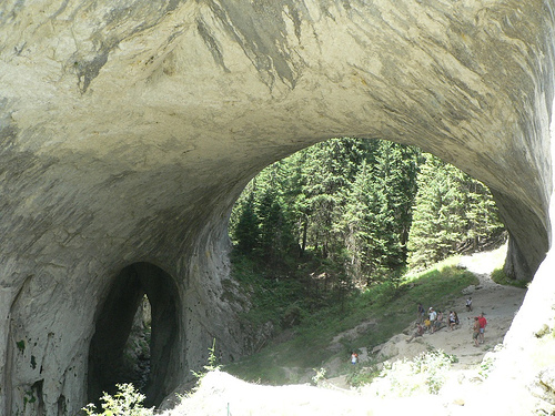
The Wonderful Bridges, also known as Chudnite Mostove or Marvelous Bridges (Чудните мостове in Bulgarian), are a stunning natural rock phenomenon consisting of massive arched bridges formed by erosion in the Rhodope Mountains of southern Bulgaria. This site exemplifies karst landscape features, where ancient river activity sculpted marble rock into bridge-like structures that span a deep valley. Located in the Western Rhodopes, the bridges are nestled in the karst valley of the Erkyupriya River (also referred to as Aidarsko Dere or Erkyupria), at an elevation of 1,450 meters above sea level, at the foot of Golyam Persenk Peak (2,091 meters). The precise coordinates are approximately 41°49′08″N 24°34′52″E. The area covers a protected natural landmark, blending dramatic geology with lush forested surroundings, and is recognized as one of Bulgaria's premier natural attractions, included in the 100 National Touristic Places under number 85. The bridges are not man-made but result from millennia of natural processes, creating an illusion of engineered arches that have captivated visitors and geologists alike. The site is part of a larger karst system with numerous undeveloped caves nearby, emphasizing its role in showcasing Bulgaria's diverse geological heritage.
The Wonderful Bridges are a prime example of karst topography
developed in marble rock, rather than typical limestone, which adds
to their unique geological significance. The formation process began
with the erosive action of the ancient Erkyupriya River, which was
once much larger and more powerful. Over thousands of years, the
river exploited cracks in the marble bedrock, gradually widening
them into a deep subterranean cave system. As the cave expanded, the
ceiling thinned in vulnerable sections and eventually
collapsed—potentially accelerated by seismic activity such as an
earthquake. The resulting debris was swept away by the river's flow,
leaving behind the arched remnants that form the "bridges" today.
This process is a classic karst evolution: caves grow, breach the
surface, and erode into open valleys or natural bridges. Some
theories suggest that roof collapses may not always be required, but
the site's features align with standard karst development models.
The site features two primary bridges along the river, with a third
smaller formation downstream:
Larger Bridge (Upstream):
Approximately 96 meters long and up to 15 meters wide at its
broadest points, it consists of three vaulted arches. The central
arch is the most impressive, measuring 45 meters high and 40 meters
wide, allowing the river to flow beneath it. The structure has a
vertical drop of about 70 meters from top to bottom.
Smaller
Bridge (Downstream, 200 meters away): 60 meters long with a total
height of 50 meters and an arch height of 30 meters. It is
impassable for visitors due to its steep and unstable nature.
Third Formation: A small, inaccessible pothole-like bridge where the
river disappears underground into an abyssal cave, reemerging on the
surface after about 3 kilometers.
The surrounding valley
itself is considered a remnant of a larger ancient cave system, with
the bridges as surviving "roof" sections. The marble composition
contributes to the site's durability and the smooth, sculpted
appearance of the arches.
Historically, the Wonderful Bridges have no evidence of ancient
human use or construction, as they are purely natural. They were
officially recognized and protected as a nature reserve in 1949,
underscoring their importance to Bulgaria's natural heritage.
Culturally, the site is tied to local folklore, including a
prominent legend from the nearby village of Zabardo. According to
the tale, shepherds plagued by a dragon tricked it into swallowing a
donkey loaded with incendiary tinder (a dry wood sponge). The
burning substance expanded inside the dragon, forcing it to burrow
through the earth in agony. Over time, as the dragon's body decayed,
the tunnels collapsed, leaving the arched bridges behind. This myth
adds a layer of enchantment to the site, blending natural wonder
with storytelling traditions of the Rhodope region.
The bridges
hold cultural significance as a symbol of Bulgaria's pristine
landscapes, featured in tourism promotions and listed in the
national registry of protected areas as a natural landmark. They are
comparable to other global karst features, such as natural bridges
in the United States or China, but distinguished by their marble
base and forested setting.
The area around the Wonderful Bridges is densely wooded with century-old coniferous forests, predominantly spruces, creating a serene, alpine-like environment. This vegetation provides habitat for various wildlife, though specific species are not extensively documented. Birds frequently nest in the marble clefts and vaults of the larger bridge, taking advantage of the sheltered niches. The site's location in the Rhodope Mountains supports a biodiverse ecosystem typical of high-altitude karst regions, including potential sightings of small mammals, insects, and endemic plants adapted to rocky terrains. Nearby undeveloped caves may harbor bat populations or other troglodytic species, but these are not accessible to the public. The environment benefits from its protected status, minimizing human impact and preserving the natural balance.
As of August 2025, the Wonderful Bridges remain a popular tourist
destination, attracting visitors for hiking, photography, and nature
appreciation, with no major changes reported in recent years. The
site is free to enter and open year-round, though access can be
challenging. It is reachable via an asphalt road branching off the
Assenovgrad-Smolyan highway toward Zabardo, about 30 km from the
town of Chepelare in Smolyan Province. The final 7-15 km of the road
is narrow (one-lane in places), steep, bumpy, and potholed, though
recent patches in 2024-2025 have improved conditions slightly; it
remains hazardous in winter due to ice and snow. Small vehicles can
navigate it, but caution is advised—pull-over spots allow passing.
For hikers, marked trails lead from Zabardo (2.5 hours) or Orehovo
via Kabata Hut (4.5 hours).
On-site infrastructure includes
secured wooden trails and railings for safe traversal on and under
the bridges, making them accessible for most visitors (though the
smaller bridge is off-limits). Facilities feature the "Wonderful
Bridges" hut (a tourist lodge near the upper bridge) and "Rock
Bridges" hut, offering accommodations, a restaurant with local
cuisine, refreshments, and souvenirs. No guided tours or lighting
are provided; visitors should bring torches for shaded areas.
Recent visitor reviews from 2024-2025 rate the site highly
(4.7/5 on platforms like Tripadvisor), praising its breathtaking
views, relaxing walks, and panoramic mountain vistas, ideal for
families, couples, and groups. Common tips include visiting in
mid-spring (e.g., May) through mid-autumn for optimal weather and
road safety, wearing sturdy shoes for uneven terrain, and allocating
1-2 hours for exploration. Complaints focus on the road's condition,
with one low rating citing winter dangers. No significant updates or
events were reported in 2024-2025 news searches, indicating stable
conservation under Bulgaria's protected areas registry. The site
combines with nearby attractions like the Bachkovo Monastery or
Smolyan for multi-day trips, enhancing its appeal as a gateway to
Rhodope adventures.