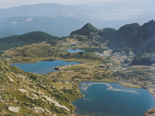
The Seven Rila Lakes, known in Bulgarian as Sedemte Rila Ezera, are a captivating group of seven glacial lakes nestled in the northwestern Rila Mountains in southwestern Bulgaria. Often hailed as one of the country's most iconic natural wonders, they form a terraced cascade of crystal-clear waters amid alpine meadows and rugged peaks, attracting hikers, nature enthusiasts, and spiritual seekers. Situated within Rila National Park, the lakes span elevations from 2,095 to 2,535 meters above sea level and are celebrated for their pristine beauty, biodiversity, and cultural significance. As Bulgaria's most visited lake group, they draw over 100,000 visitors annually, blending ecological fragility with tourism appeal. Formed during the Pleistocene glaciation, they exemplify high-mountain hydrology and serve as a vital water source for regional rivers. In 2025, ongoing concerns about climate change and tourism impacts underscore their status as a protected yet vulnerable heritage site, with recent studies highlighting risks like eutrophication from hiking trails.
The lakes are located in the Damga cirque of the northwestern Rila Mountains, approximately 90 km south of Sofia, within the boundaries of Rila National Park—the largest national park in Bulgaria, covering 810 km². The area features a dramatic alpine landscape with steep granite cliffs, glacial valleys, and meadows, positioned between latitudes 42°11'40"N and longitudes 23°18'50"E. Elevations range from 2,095 m at the lowest lake to 2,535 m at the highest, with the surrounding peaks like Haramiyata and Otovishki reaching over 2,700 m. The terrain is characterized by moraines, boulder fields, and small streams connecting the lakes, creating a stepped formation over a vertical drop of about 440 m. Nearby features include the source of the Dzherman River and proximity to other glacial lakes in the park, totaling nearly 200. The climate is alpine, with average summer temperatures around 10–15°C, harsh winters dropping to -10°C or lower, and annual precipitation of 900–1,200 mm, often as snow that persists until June.
The Seven Rila Lakes originated from glacial activity during the last Ice Age (Pleistocene), when retreating glaciers carved out cirques and depressions that filled with meltwater. This process created a series of tarn lakes in a classic glacial staircase formation, with each lake overflowing into the next via streams and cascades. The underlying geology consists of ancient granite and gneiss bedrock from the Rila massif, shaped by erosion and tectonic uplift. Moraines and till deposits border the lakes, contributing to their oligotrophic (nutrient-poor) nature. Over millennia, post-glacial processes like weathering and sediment accumulation have influenced their depths and shapes. Recent studies project minimal changes in water levels by 2070 but note increasing temperatures could accelerate evaporation and alter hydrology.
Each lake is uniquely named after its shape or features, listed from
highest to lowest elevation:
The Tear (Sǎlzata / Сълзата): At
2,535 m, the highest and smallest (0.7 ha, depth 4.5 m), with
exceptionally clear waters resembling a teardrop.
The Eye (Okoto /
Окото): Oval-shaped at 2,440 m (6.8 ha, depth 37.5 m), the deepest in
Bulgaria, known for its intense blue hue and reflective surface.
The
Kidney (Bǎbreka / Бъбрека): Kidney-like at 2,282 m (8.5 ha, depth 28 m),
with steep shores; often considered the most photogenic.
The Twin
(Bliznaka / Близнака): Largest by area at 2,243 m (9.1 ha, depth 27.5
m), splits into two during low water, surrounded by meadows.
The
Trefoil (Trilistnika / Трилистника): Irregular, clover-like at 2,216 m
(2.6 ha, depth 6.5 m), with low shores and unique biodiversity.
The
Fish Lake (Ribnoto Ezero / Рибното езеро): Shallowest at 2,184 m (3.5
ha, depth 2.5 m), once fish-rich; near a hiking hut.
The Lower Lake
(Dolnoto Ezero / Долното езеро): Lowest at 2,095 m (5.9 ha, depth 11 m),
collects outflow to form the Dzherman River.
The lakes form a interconnected system where water flows downhill via streams and waterfalls, with the upper lakes feeding the lower ones. The Lower Lake acts as the primary outlet, giving rise to the Dzherman River, a tributary of the Struma River flowing to the Aegean Sea. Water balance is influenced by snowmelt (peaking in spring), rainfall, and evaporation, with total catchment area around 2 km². Projections indicate stable or slightly declining levels due to warming, with water temperatures rising 1–2°C by 2070.
The lakes are oligotrophic, supporting limited but specialized life due to cold, nutrient-poor waters. Flora includes alpine meadows with edelweiss, gentians, and endemic species like Rila primrose, alongside coniferous forests (pine, spruce) at lower edges. Fauna comprises chamois, golden eagles, marmots, brown bears, and amphibians like alpine newts; fish are sparse but include introduced trout in some lakes. Phytoplankton and zooplankton dominate aquatic ecosystems, vulnerable to shifts in trophic status. Biodiversity is high, with over 50 endemic species in the park, but threats include invasive plants and habitat fragmentation.
Part of Rila National Park (UNESCO Man and Biosphere Reserve since 1977), the lakes face risks from climate change (warming, reduced snow cover) and tourism (soil erosion, eutrophication). Studies show hiking trails degrade 14% of habitats, introducing nutrients that alter phytoplankton communities and accelerate eutrophication, especially in Ribnoto and Trilistnika Lakes. Vulnerability assessments predict impacts on water depth and ecosystems by 2100 under RCP scenarios. Recommendations include trail monitoring, visitor limits, banning off-road vehicles, and enhanced succession tracking to preserve oligotrophic status.
A premier hiking destination, accessible via a chairlift from Pionerska Hut (1,570 m) to Rila Lakes Hut (2,150 m) for 30 BGN round-trip. The 8.2 km loop trail (medium difficulty, 3–4 hours) offers panoramic views, rated family-friendly but with steep sections to The Tear. Best visited July–September for blooms and mild weather; winter hikes require gear. Tips: Arrive early, carry cash/water, stay on paths, and respect no-litter rules. Accommodations include huts; organized tours from Sofia available. In 2025, expect crowds, with entry fee 4 BGN/person.
The lakes hold mystical allure, linked to Thracian and Slavic folklore as sacred sites with healing energies. Modernly, they are central to the White Brotherhood (followers of Peter Deunov), who gather annually in August at The Trefoil for Paneurhythmy dances, viewing the lakes as cosmic energy portals. Legends describe them as tears of giants or divine creations, symbolizing purity and renewal.
As of August 2025, a February study emphasized trail-induced eutrophication, prompting calls for stricter visitor management. Infrastructure remains stable, with the chairlift operating year-round (weather permitting). EU-funded monitoring enhances conservation, while tourism surges post-pandemic, with guides recommending sustainable practices amid warming trends.