Location: Northern Bohemia Map
Transportation:
car 1.5 hours 100 km from Prague
Telephone: 481366255, 481366256
Fax: 481366256
Area: 181 km²
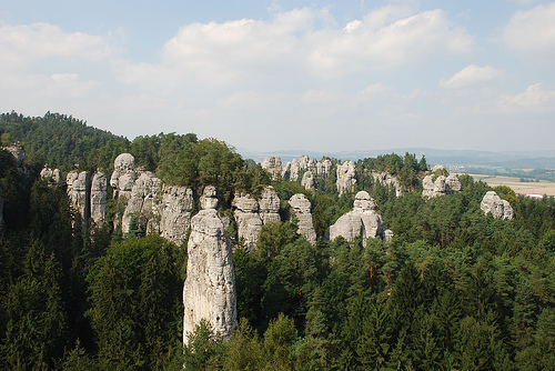
The Český ráj (Bohemian Paradise) is a low mountain landscape in the north-east of the Czech Republic on the middle reaches of the Jizera. The landscape is characterized above all by the famous "rock cities" made of sandstone. Since 1955, part of the region has been under nature protection as Chráněná krajinná oblast Český ráj, making it the oldest large-scale protected area in the country. Due to its special geological structure, the region was included in the networks of European and global geoparks in 2005, and has been a UNESCO Global Geopark since 2015. The symbol of the Bohemian Paradise is Trosky Castle.
The protected landscape area is 181.5 km² in size. The area belongs
to mainly small rural communities in parts of the Semily, Mladá Boleslav
and Jičín districts. However, there is no exact border for the region.
In essays, books and songs, towns such as Mladá Boleslav, Bezděz, Český
Dub and Sychrov in the west, Bozkov in the north, Nová Paka and
Konecchlumí in the east and Kopidlno, Staré Hrady and Libáň in the south
are included in the region.
The protected area consists of three
separate parts. The geopark, which was declared in 2005, connects them
and also includes the surrounding, non-protected landscape. It extends
to 700 km². The Český ráj tourist region also includes the surrounding
area with 126 municipalities and a total area of 1091 km². In the
east, the region borders on the foothills of the Giant Mountains, in the
north the hilly landscape merges into the Jizera Mountains. To the west
are the wooded areas of the Ralská Pahorkatina. The landscape in the
south, which belongs to the Bohemian Pan, is flat and agricultural.
The Bohemian Paradise belongs to the Bohemian Table mountain
formation (Česká tabule). Sediments from the Mesozoic sea form the
subsoil for sandstone rocks that were formed in the late Cretaceous
period. The sandstone formations form extensive plateaus that are
comparable to the rocky areas of Saxon Switzerland. The most famous rock
towns are Hruboskalsko, Prachovské skály, Příhrazské skály, the
Klokočské skály and Betlémské skály.
The sandstone plateaus are
broken up by deep ravines. There are also isolated but striking volcanic
conical mountains, extensive forests, cultivated land and ponds embedded
in nature, including the Oborský rybník with 11.4 hectares of water
surface. There are good views from the vantage points on the highest
mountains, Kozákov (744 m) and Kopanina (657 m).
In agriculture, arable farming is predominant, pastureland is less common. Conifers dominate the forests. Mixed deciduous forests have been preserved in places. Valuable wild plant populations can be found particularly in the ravine forests and wetlands. Eagle owls, falcons, ravens and stone martens find favourable conditions in the rocks, and kingfishers, white storks and grey herons can be seen in the wetlands. The Bohemian Paradise is not an untouched natural area, but a cultural landscape that has been inhabited and cultivated for several millennia, the value of which is seen above all in the typical character of the sandstone rocks. No large industrial companies have ever settled in the region. Ecological dangers are particularly posed by agriculture and mountain tourism.
The region has been inhabited since the Neolithic period. The
earliest settlements were limited to the fertile valley plains, the
rocks remained uninhabited with the exception of Skály na Mužském. On
Kozákov Hill there were workshops for processing jasper. Around 1100 BC,
a dense network of settlements of the Lusatian culture was formed. The
villages were only 1-2 kilometers apart, and numerous traces of
settlement from this period have been found on the rocks and especially
in the caves. Fortified hilltop castles were built on Mužský Hill, in
Hrubá skála and in Prachovské skály, among others. The system of
well-protected and strategically located fortified settlements remained
in use until the Middle Ages, although no settlement continuity can be
established.
The settlement structure changed from the 11th
century AD at the latest. The local nobility built numerous fortified
manor houses and castles in the higher elevations, which still
characterise the landscape today.
The region's development as a
tourist destination began in the early 19th century in the area of
Nová Ves (Wartenberg in German), known as Sedmihorky from 1966
onwards. The air and cold water spa founded there in 1841: Lázně
Sedmihorky, named after the mineral spring "Sedmihorka", offered guests
particularly clean air and several cold healing springs, of which the
Aloisien spring is the most important. One of the first guests, the
Czech poet Karel Havlíček Borovský, coined the name Bohemian Paradise in
the same year, which quickly caught on and which the region still bears
today. The first "Travel Guide to the Bohemian Paradise" was written in
1885 by Josef Zdenko Pryl at the instigation of the founder and director
of the Sedmihorky spa in Nová Ves, Dr. Antonín Vincenc Šlechta.
Many Czech artists found inspiration in Sedmihorky and its surroundings.
The composer Bedřich Smetana spent a good part of his last years here.
From 1876 to 1884 he stayed in Jabkenice and composed, among other
things, "Tábor" and "Blaník", the last two symphonic poems from the
cycle "My Fatherland" (Má Vlast).
The region has numerous cultural and historical monuments and natural
attractions. These include the castles of Kost and Trosky, Vranov,
Valdštejn, Zbiroh, Drábské světničky, Rotštejn, Valečov, built on high
rocks, and the castles of Hrubá Skála, Hrubý Rohozec and Humprecht.
The log-built farmhouses are considered to be particularly typical
of the region, the most famous example being the Kopicův statek,
formerly Jirošova rychta, an example of folk architecture in the village
of Kacanovy, Okres Semily.
The Prachovské skály, Hrubá skála, Suché skály and Skály na Mužském
rock areas are of interest to climbers. A significant peak here is the
Mare (Kobyla) in Příhrazy. Baton, Lighthouse, Kapellmeister and the
Dragon Rocks are the most important peaks in the Hrubá skála. In
Prachovské skály these are the Raven Towers, the Prachauer Nadel and the
Prachauer Mütze. Climbing has been taking place here since the 1920s,
initially mainly by climbers from Liberec and Dresden. Later, especially
after the Second World War, more and more local Czech climbers joined
in.
Please note that climbing is not allowed for 48 hours after
rain due to the very soft rock. The exception is the Suché skály rocks,
which are made of very hard sandstone.
The municipalities of Sobotka, Mladějov, Troskovice, Libošovice, Olešnice, Hrubá Skála, Karlovice, Kacanovy, Ktová, Vyskeř, Osek, Dobšín, Branžež and Kněžmost have joined forces in the Český ráj microregion.