Location: Wales Map
Ewloe Castle, known in Welsh as Castell Ewloe, is a remarkable
example of native Welsh castle architecture, standing as one of the few
surviving fortifications built by the indigenous Princes of Wales rather
than by English invaders. Unlike the imposing stone fortresses
constructed by Edward I and his successors, Ewloe embodies the strategic
ingenuity of medieval Welsh rulers in a contested border region.
Situated in a secluded, forested hollow rather than on a commanding
hilltop—a deliberate choice to blend into the landscape for defensive
surprise—it overlooks the confluence of two streams in the wooded valley
of Wepre Park, near the village of Ewloe in Flintshire, north-east
Wales. Its coordinates are approximately 53°12′00″N 3°04′01″W, placing
it strategically along the historic Wales-England border, close to the
A55 road and about 2 miles (3.2 km) northwest of Hawarden. This
low-lying position in the cantref of Tegeingl (part of the Perfeddwlad,
or "middle country" between the Welsh heartlands and English lowlands)
allowed it to control key routes while remaining concealed amid dense
woodland, a tactic suited to guerrilla-style Welsh warfare against
superior English forces.
The castle's name derives from the Welsh
"Ewlo," possibly linked to the nearby River Wepre or ancient Celtic
roots, and it has been a symbol of Welsh resistance since its
construction in the early 13th century. Today, it is a Grade I listed
ruin managed by Cadw, Wales's historic environment service, offering
free public access and evoking a sense of mystery through its
integration with the surrounding ancient oaks and ferns.
Ewloe's history is intertwined with the turbulent Anglo-Welsh
conflicts of the 12th and 13th centuries, though records are sparse due
to the oral traditions of the period and the destruction of Welsh
archives. An early fortification may have existed on the site following
the Battle of Ewloe in 1157, when Owain Gwynedd, Prince of Gwynedd,
decisively defeated an invading English army led by Henry II near the
location, securing temporary Welsh dominance in the borderlands.
However, the standing stone castle we see today dates primarily to the
13th century, marking it as one of the last major native Welsh
strongholds before Edward I's conquest.
Construction likely began
in the 1210s under Llywelyn ab Iorwerth (Llywelyn the Great, r.
1195–1240), grandfather of the famous Llywelyn ap Gruffudd. Recent
scholarship suggests building started as early as 1213–1218 or
1221–1237, rather than the previously assumed 1257 under Llywelyn ap
Gruffudd (Llywelyn the Last, r. 1258–1282). Llywelyn the Great, at the
height of Gwynedd's power, initiated the core D-shaped tower as a symbol
of sovereignty during his campaigns to consolidate control over
Perfeddwlad after reclaiming it from English barons. The castle was
briefly abandoned after Dafydd ap Llywelyn's defeat in the First Welsh
War (1244–1246), when Henry III reasserted English authority, but it was
recaptured and refurbished by Llywelyn ap Gruffudd in 1256–1257 during
his reconquest of the region.
Ewloe served as a diplomatic and
military hub in the 1250s and 1260s. In 1259 and 1260, Llywelyn ap
Gruffudd used it as a backdrop for tense negotiations with English
envoys, including those from Henry III, highlighting its role in fragile
truces. By 1277, during Edward I's first major invasion of Wales, the
castle—now outdated against English siege engines—may have been besieged
but offered little strategic value to the victors, leading to its swift
abandonment and deliberate slighting (partial demolition) to prevent
reuse. The last contemporary mention appears in the 1311 Chester Plea
Rolls, which recounted its mid-12th-century origins and noted its
reinforcement in 1257. By the late medieval period, much of its dressed
stone was quarried away for local buildings in nearby Mold and Connah's
Quay, accelerating its decline into ruin.
In modern times, the
site gained renewed attention in November 2009 when the castle and 24
acres (9.7 hectares) of surrounding land were auctioned for £122,000 to
an anonymous farmer. Flintshire County Council intervened to safeguard
it from development, ensuring its preservation within Wepre Park, a
public country park.
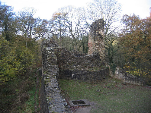
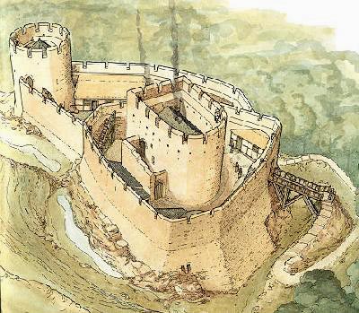
Ewloe Castle exemplifies the hybrid "Welsh keep" style, blending
motte-and-bailey elements with enclosure castle designs, all constructed
from locally quarried sandstone—a practical choice reflecting
resource-limited Welsh building practices. Unlike the symmetrical,
concentric layouts of Edwardian castles, Ewloe's design is asymmetrical
and piecemeal, evolving over decades without a grand master plan, which
adds to its organic, fortress-like character.
The core structure is
the iconic D-shaped tower, often called the "Welsh keep," perched on a
natural stone outcrop that forms the motte. Rising about 11 meters (36
feet) high, with walls up to 2 meters (6.7 feet) thick at the base, it
features a ground-floor chamber (possibly a storeroom or prison) and a
first-floor hall for the princely residence. Defensive arrowslits pierce
the curved outer walls for crossbow fire, while the flat inner face
overlooks the outer ward through a rare Romanesque-style window with
rounded arches—a nod to earlier Norman influences adapted by Welsh
builders. At its base lies a stone revetment (chemise), a sloping
protective skirt to deter undermining.
Enclosing the site are
irregular curtain walls with parapet walkways, dividing the castle into
two wards: a small, triangular upper inner ward (about 0.1 hectares) for
elite use, and a larger lower outer ward for support activities like
stabling or storage. The outer ward's walls converge at a circular
western tower on a rocky knoll, providing enfilading fire along the
approaches. Notably, there are no formal gateways between wards; access
relied on wooden ramps and ladders to the parapets, emphasizing rapid
assembly for defense over everyday convenience. To the south, an
external rampart and rock-cut neck ditch exploit the higher ground,
creating a natural choke point.
The overall footprint is
compact—spanning just 0.2 hectares—suited to a small garrison of 20–30
men, with the woodland setting enhancing camouflage. Water supply came
from nearby streams, and the promontory's steep slopes (dropping 20–30
meters) formed natural cliffs on three sides. This design prioritized
ambush and withdrawal over prolonged sieges, contrasting with the
resource-heavy English castles like nearby Flint or Rhuddlan.
Ewloe holds profound historical significance as a testament to Welsh
autonomy in an era of creeping English domination. It represents the
zenith of native princely power under the House of Gwynedd, with its
construction and expansions underscoring Llywelyn the Great's vision of
a unified Wales. As the only substantially surviving castle built by a
Welsh ruler (others like Dinas Brân are more ruined), it offers
invaluable insights into indigenous military architecture—favoring
rugged terrain and local materials over imported expertise. Its
borderland role symbolizes the "marcher" conflicts, where Welsh forces
used mobility and terrain to challenge English feudalism.
Culturally,
Ewloe inspires romantic notions of medieval Wales, appearing in
literature and folklore as a haunt of princes and bards. Its forested
seclusion has drawn artists and historians, evoking the "green castles"
of Welsh poetry. In broader terms, it highlights themes of resistance
and adaptation, paralleling other native sites like Criccieth or
Dolwyddelan.
Today, Ewloe is a picturesque ruin, with ivy-clad walls and mossy stones evoking a fairy-tale atmosphere amid Wepre Woods' trails. Managed by Cadw since the 20th century, it remains free to visit year-round (1 April to 31 March), though terrain is moderately challenging (Level 3: uneven paths, steep slopes, and woodland roots). Access is via a 500-meter walk across farmland from a lay-by parking for five cars off the A55 (postcode CH5 3BZ; what3words: ///stag.porridge.large). Dogs are welcome on short leads for ground-floor access, but drones and smoking are prohibited. It's reachable by bike via National Cycle Network Routes 5 or 568 (about 5.1 km/3.2 miles from Ewloe).