Location: 40 km South of Xunantunich, Cayo District Map
8am - 5pm
Caracol, located in the Cayo District of western Belize within the Chiquibul National Park, is the largest Maya archaeological site in Belize and one of the most significant in the Maya world. Covering approximately 200 square kilometers (77 square miles), it was a major political, economic, and ceremonial center from the Preclassic Period (600 BCE) to the Terminal Classic (900 CE), with a peak population of 100,000–150,000 during the Late Classic (600–800 CE). Situated in the rugged Maya Mountains, Caracol’s most iconic feature is the 141-foot (43-meter) Caana pyramid, Belize’s tallest man-made structure, offering panoramic views of the jungle and Guatemala. Its extensive causeway system, intricate stelae, and military victories over Tikal and Naranjo underscore its regional dominance.
Caracol’s historical trajectory reflects its rise from a modest
settlement to a Maya superpower, followed by a rapid decline:
Preclassic Period (600 BCE–250 CE): Caracol began as a small
agricultural village, with evidence of maize cultivation and early
structures by 600 BCE. By the Late Preclassic (300 BCE–250 CE),
monumental construction, including precursors to Caana, indicated
growing social complexity. The site likely served as a regional hub in
the Belize River Valley.
Early Classic (250–600 CE): Caracol emerged
as a significant city-state, with a population of around 20,000. The
establishment of a royal dynasty, documented in stelae, marked its
political ascent. In 562 CE, under Lord Water (Yajaw Te’ K’inich II),
Caracol defeated Tikal in a pivotal “Star War” (guerra estelar), a
ritually significant conflict, cementing its dominance. This victory,
recorded on Altar 21, disrupted Tikal’s regional influence for decades.
Late Classic (600–800 CE): Caracol reached its zenith, with a population
of 100,000–150,000, rivaling Tikal’s size. Under rulers like K’an II
(618–658 CE) and Smoke Imix (658–695 CE), the city expanded its causeway
system, built Caana’s final phase, and defeated Naranjo in 680 CE.
Hieroglyphs detail alliances, marriages, and military campaigns, linking
Caracol to sites like Calakmul. Its agricultural terraces and reservoirs
supported a dense urban sprawl, with over 35,000 structures mapped.
Terminal Classic (800–900 CE): Around 850–900 CE, Caracol declined
rapidly, likely due to drought, warfare, or internal strife, aligning
with the broader Maya collapse. Construction ceased, and the population
dwindled, though some elite activity persisted until 950 CE. Evidence of
burning in elite residences suggests possible rebellion or invasion.
Postclassic and Colonial Periods (900–1500s CE): Minimal ritual activity
occurred, with caches indicating pilgrimage use. The site was abandoned
by the Spanish arrival, its jungle location shielding it from colonial
interference.
Modern Rediscovery: Discovered in 1937 by logger Rosa
Mai, Caracol was first excavated by A.H. Anderson in 1938, who named it
after the Spanish word for “snail,” possibly referencing its winding
trails. Major excavations began in 1985 under Arlen and Diane Chase of
the University of Central Florida, whose 40-year Caracol Archaeological
Project (CAP) used LiDAR (2010–2013) to map 23,000 structures and 177 km
of causeways. The Chases’ work revealed Caracol’s urban scale,
challenging earlier views of Maya cities as ceremonial-only.
Caracol’s history highlights its military prowess, urban sophistication,
and eventual collapse, offering a microcosm of Classic Maya dynamics.
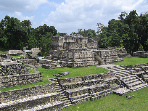
Caracol’s core spans 2.5 square kilometers, with over 35,000
structures, including pyramids, palaces, ball courts, and reservoirs,
connected by a 177-km causeway system linking residential and
agricultural zones. Built on a limestone plateau, the site’s
architecture features corbelled arches, stucco decorations, and precise
celestial alignments. Key features include:
Caana (“Sky Palace”):
A 141-foot (43-meter) pyramid, the tallest in Belize, dominating the
Central Acropolis. Built in phases from 300 BCE to 800 CE, it comprises
three temples atop a massive platform, with elite residences and tombs
below. The summit, accessible via steep steps, offers views of the Maya
Mountains and Guatemala. Caana symbolized royal power, hosting rituals
and burials.
Central Acropolis:
The main ceremonial and
administrative hub, surrounding Caana with plazas (A and B) and
structures like Temples A1–A6. Plaza A houses six stelae and altars,
detailing rulers and victories. The acropolis includes elite residences
and a ball court, reflecting political and ritual functions.
Barrio and South Acropolis:
Secondary plazas with temples and
palaces, used by sub-elite families. The South Acropolis, older than
Caana, contains Preclassic structures and a royal tomb with jade and
ceramics.
Ball Courts:
Two courts, one near Caana and another
in the Barrio, hosted the ritual ballgame, symbolizing cosmic battles.
Markers and caches suggest high-stakes games, possibly involving
sacrifice.
Causeway System:
A 177-km network of raised roads,
up to 10 meters wide, connects the core to outlying termini (e.g., Cahal
Pichik, Ceiba), facilitating trade, ceremonies, and agriculture. LiDAR
revealed causeways linking residential clusters and terraced fields,
supporting a sprawling metropolis.
Reservoirs and Terraces:
Over 50 reservoirs, some lined with clay, managed water for 100,000
residents. Agricultural terraces, covering 80% of the site’s hinterland,
grew maize, beans, and cacao, with LiDAR mapping 1,500 km² of fields.
Stelae and Altars:
Over 24 stelae and 30 altars, concentrated in
Plaza A, depict rulers like K’an II and Smoke Imix. Altar 21 records the
562 CE Tikal victory, while Stela 3 details royal lineage. Glyphs
provide a 400-year dynastic history.
Caracol’s urban scale, with
causeways integrating a dispersed population, challenges traditional
views of Maya cities as compact ceremonial centers, highlighting its
sophisticated infrastructure.
Caracol was a political, religious, and economic powerhouse,
embodying Maya cosmology and governance:
Religious Practices:
Caana and other temples hosted bloodletting, incense burning, and
offerings to gods like Chaac (rain) and Kinich Ahau (sun). Tombs with
jade, ceramics, and stingray spines (for bloodletting) reflect afterlife
beliefs. The site’s alignment with solstices and equinoxes underscores
astronomical expertise, with E-Groups (astronomical complexes) marking
celestial events.
Political Power: Stelae and altars glorify rulers,
with glyphs detailing victories over Tikal (562 CE) and Naranjo (680
CE). Caracol’s dynasty, spanning 300–900 CE, used warfare and marriage
alliances (e.g., with Calakmul) to dominate the Petén. The causeway
system facilitated centralized control over a vast populace.
Trade
and Economy: Caracol’s location in the Maya Mountains enabled trade in
jade, obsidian, cacao, and marine shells, connecting it to coastal sites
(e.g., Altun Ha) and the Petén. Terraced agriculture and reservoirs
sustained a dense population, with surplus goods fueling elite wealth.
Decline: The rapid collapse around 850–900 CE, with evidence of burning
and abandoned projects, likely stemmed from drought, overpopulation, or
rebellion, though glyphs are silent on the cause. Postclassic caches
suggest lingering reverence.
Caracol’s cultural significance lies in
its military triumphs, urban innovation, and enduring spiritual legacy,
with its glyphs offering one of the Maya world’s richest historical
records.
The Caracol Archaeological Project has uncovered a wealth of
artifacts, many housed at Belize’s Museum of Belize or the on-site
visitor center:
Stelae and Altars: Over 54 monuments, including
Stela 3 (royal lineage) and Altar 21 (Tikal victory), provide a 400-year
dynastic chronicle. Carvings depict rulers in ceremonial regalia, with
glyphs detailing dates and events.
Jade and Obsidian: Beads, ear
flares, and blades, found in royal tombs, reflect trade with Guatemala’s
Motagua Valley. A jade mask in Caana’s tomb is a highlight.
Ceramics:
Polychrome vessels, incense burners, and figurines, dating from 600 BCE
to 900 CE, depict gods, animals, and rulers. Caches in reservoirs
contained ceramic offerings.
Burials: Over 200 tombs, including a
royal tomb in the South Acropolis with a painted vessel and jade,
indicate elite status. Caana’s tombs held stingray spines and mercury,
rare ritual items.
Altar Markers: Ball court markers and plaza
altars, some with hieroglyphs, link rituals to cosmology.
Caracol’s
artifacts, preserved by its remote jungle setting, offer a detailed
record of Maya artistry, trade, and religion, with LiDAR revealing
untapped excavation potential.
Caracol lies within the 1.2-million-acre Chiquibul National Park, a
tropical rainforest in the Maya Mountains at 1,600–2,600 feet (500–800
meters) elevation. The limestone plateau, with granite outcrops,
supports a biodiverse ecosystem:
Flora: Ceiba trees (sacred to
the Maya), mahogany, sapodilla, and cohune palms dominate, with orchids,
bromeliads, and vines creating a dense canopy. Agricultural terraces,
still visible, supported ancient crops.
Birds: Over 200 species,
including orange-breasted falcons, keel-billed toucans, ocellated
turkeys, and scarlet macaws. Crested guans and motmots are common near
Caana.
Mammals: Howler and spider monkeys, jaguars, ocelots, pumas,
and Baird’s tapirs inhabit the forest. Monkeys often perch on pyramids,
delighting visitors.
Reptiles and Amphibians: Green iguanas,
Morelet’s crocodiles (in reservoirs), and fer-de-lance snakes are
present. Frogs thrive post-rain.
Conservation: Chiquibul National
Park, part of the Maya Forest Corridor, protects biodiversity, though
illegal logging and poaching from Guatemala pose threats. The Belize
Forest Department and CAP enforce preservation.
The jungle setting,
with cooler temperatures (60–80°F) than coastal Belize, creates an
immersive experience, though mosquitoes require repellent, especially in
the wet season (June–November).
Caracol’s remote location and vast scale make it a rewarding but
challenging destination, best suited for history enthusiasts and
adventurers. Key details include:
Access:
Located 50 miles (80
km) south of San Ignacio, a 2.5–3-hour drive via the Western Highway and
Chiquibul Road, a rough, unpaved track requiring a 4WD vehicle (rentals
~$50–$100 USD/day). The route passes Douglas D’Silva (Augustine), where
permits are checked. No public transport; tours (~$100–$150 USD) from
San Ignacio or Belmopan are recommended.
Open daily 8 AM–5 PM, with a
$5 USD ($10 BZD) entrance fee for non-nationals, payable at the visitor
center. Military escorts, required due to occasional border tensions
with Guatemala, accompany visitors from Douglas D’Silva.
Tours:
Guided tours (3–4 hours, ~$100–$150 USD) cover Caana, Plaza A, the ball
court, and stelae, with guides explaining glyphs and Tikal’s defeat.
Operators like Pacz Tours or Maya Walk offer full-day trips, often
including Rio On Pools or Rio Frio Cave in Mountain Pine Ridge.
Self-guided visits are possible with maps, but guides enhance context.
Group sizes: 4–12, suitable for moderate fitness levels due to climbing
Caana’s steep steps. Tours depart San Ignacio at 7–8 AM to maximize
daylight.
Facilities:
A visitor center near Caana features
exhibits on glyphs, artifacts, and LiDAR maps, plus restrooms and a gift
shop. A picnic area with benches is available, but no dining; bring
snacks, water, and bug spray. Rangers and military personnel ensure
safety.
Parking is near the entrance, with a short trail to the core.
The site’s remoteness limits amenities, but the jungle ambiance
compensates.
Accommodations:
San Ignacio offers hotels like
Cahal Pech Village Resort (~$100 USD/night), Midas Resort (~$70
USD/night), or hostels (~$20 USD/night). Eco-lodges in Mountain Pine
Ridge, like Blancaneaux Lodge (~$300 USD/night) or Gaia Riverlodge
(~$200 USD/night), are 1–2 hours away. No camping is allowed at Caracol.
Activities:
Climb Caana for breathtaking views, explore Plaza A’s
stelae, and walk causeways to unexcavated mounds. The visitor center’s
exhibits provide context. Birdwatching and monkey-spotting are
highlights, with trails revealing jungle wildlife.
Combine with
Mountain Pine Ridge’s waterfalls (e.g., Big Rock Falls) or Barton Creek
Cave for a full-day itinerary.
Tips:
Wear sturdy shoes, long
pants, and a hat. Bring sunscreen, bug spray, binoculars, and a camera
for stelae and vistas. A raincoat is useful in the wet season.
Dry
season (November–May) ensures better road access; wet season
(June–November) risks mud and delays but enhances jungle lushness. Check
road conditions with the Belize Forest Department.
Respect the site:
Do not touch glyphs or climb unrestored structures. Stay with guides to
avoid snakes or disorientation.
Allow 6–8 hours for a round trip from
San Ignacio, including 3–4 hours on-site.
Environmental Threats: Jungle overgrowth and humidity erode stelae
and plaster, requiring constant maintenance. Heavy rains increase
landslide risks in the Maya Mountains. Climate change-driven droughts
affect reservoirs and wildlife.
Tourism Impact: Foot traffic on Caana
risks structural wear, though restricted summit access mitigates damage.
The site’s remoteness limits crowds, but 4WD vehicle tracks erode
trails.
Preservation: Looting in the 1970s depleted some tombs, with
artifacts appearing in private collections. The Belize Institute of
Archaeology and CAP use LiDAR to monitor unexcavated areas, while
rangers deter vandalism. Stelae are covered during off-seasons to
prevent weathering.
Border Issues: Caracol’s proximity to Guatemala
(10 miles) raises security concerns due to illegal logging and poaching.
Military escorts, while ensuring safety, can feel intrusive to visitors.
Biodiversity Protection: Chiquibul’s wildlife faces threats from
cross-border poaching, with scarlet macaws particularly vulnerable. The
Maya Forest Corridor aims to maintain ecological connectivity.
Caracol’s narrative as a “lost city” rediscovered by modern archaeologists can overshadow local Maya knowledge, with Rosa Mai’s 1937 discovery often framed as incidental. Population estimates of 100,000–150,000, based on LiDAR and structure counts, are robust but rely on assumptions about household sizes, potentially inflating urban density. The Tikal victory (562 CE) is well-documented, but Caracol’s broader role in Petén politics, particularly its Calakmul alliance, remains underexplored due to incomplete glyph translations. The collapse narrative, tied to drought or rebellion, simplifies complex socio-political dynamics, as Caracol’s late resilience suggests adaptive strategies. The Chases’ LiDAR work revolutionized Maya urban studies, but their focus on Caracol’s metropolis may overemphasize its uniqueness compared to other sprawling sites like Calakmul. Conservation efforts are strong, but funding shortages and border tensions limit infrastructure, with the military presence potentially deterring tourists. Community benefits from tourism, particularly for local Maya, are minimal, raising equity concerns.