Location: Cayo District Map
Baking Pot is a major Maya archaeological site in the Belize River Valley, known for its extensive urban settlement, monumental architecture, and long occupational history spanning from the Preclassic to Postclassic periods (approximately 600 BC to AD 1000). Located in the Cayo District, it is one of the largest Maya centers in the region, alongside sites like Xunantunich and Cahal Pech. Despite its historical importance, Baking Pot remains less visited than Belize’s more famous ruins, offering a quieter, more authentic experience for archaeology enthusiasts, researchers, and adventurous travelers. Its name, possibly derived from a colonial-era term for a riverside clay deposit or a local landmark, reflects its setting along the Belize River.
Baking Pot lies in the fertile Belize River Valley, approximately 6
miles (10 km) east of San Ignacio, the Cayo District’s main town, and
about 2 miles (3 km) south of the George Price Highway (formerly Western
Highway) near the village of Spanish Lookout. The site is accessible via
a short dirt road from the highway, making it reachable by car or guided
tour from San Ignacio or Belmopan (20 miles away). Its coordinates are
roughly 17°11′N, 89°01′W.
The site’s geography is defined by:
Belize River: Baking Pot sits on the southern bank of this slow-moving,
meandering river, which provided water, fertile soils, and a trade route
for the ancient Maya. The river’s alluvial plains supported intensive
agriculture, key to the city’s growth.
Tropical Lowlands: The
surrounding landscape is a mix of broadleaf rainforest and savanna, with
mahogany, ceiba, and cohune palm trees. Wildlife includes howler
monkeys, agoutis, jaguars (rare), and over 200 bird species, such as
toucans and oropendolas.
Limestone Terraces: The site is built on
gently rolling terrain, with natural limestone ridges shaped into
terraces and platforms for buildings. Nearby karst hills, part of the
Maya Mountains’ foothills, contain caves used for Maya rituals.
Agricultural Fields: Raised fields and drainage systems around Baking
Pot indicate sophisticated farming, supporting a dense population.
The climate is tropical, with temperatures of 80–90°F and high humidity.
The dry season (February–May) offers easier access and clearer views,
while the wet season (June–November) brings lush greenery but muddy
trails.
Baking Pot was a thriving Maya city with a continuous occupation from
the Middle Preclassic (ca. 600 BC) to the Postclassic (ca. AD 1000),
peaking during the Late Classic (AD 600–850). It served as a political,
economic, and ceremonial hub in the Belize River Valley, likely
interacting with larger centers like Tikal (Guatemala) and Caracol
(Belize). Archaeological evidence, primarily from excavations by the
Belize Valley Archaeological Reconnaissance Project (BVAR) since the
1990s, reveals a complex urban society.
Key historical features
include:
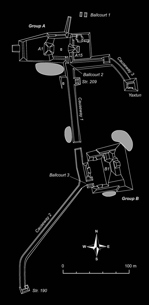
Urban Layout: Baking Pot spans several square kilometers,
with a central core of monumental architecture surrounded by residential
zones, causeways, and agricultural fields. The core includes two main
groups (Group A and Group B), connected by a sacbe (elevated causeway),
and numerous smaller plazas and hamlets.
Monumental Architecture:
Group A: Features a large plaza with pyramids, temples, and elite
residences. The tallest structure, a partially restored pyramid, reaches
about 33 feet (10 meters), offering views of the valley.
Group B:
Includes a royal palace complex and a ballcourt, a hallmark of Maya
cities where ritual games symbolized cosmic battles. The ballcourt’s
markers and rings are partially intact.
Eastern Shrine: A distinctive
feature, this tomb-like structure in Group A contained elite burials
with jade, obsidian, and ceramic offerings, suggesting ancestor worship.
Stelae and Altars: Unlike Nim Li Punit or Xnaheb, Baking Pot has fewer
carved stelae, but plain stelae and altars mark ceremonial spaces,
possibly commemorating rulers or events.
Causeways: Three sacbeob
(causeways) link the core to outlying groups, facilitating trade and
processions. The longest stretches over 1 km, connecting to a
residential hamlet.
Burials and Artifacts: Excavations uncovered
royal tombs with polychrome pottery, jade jewelry, and stingray spines
(used in bloodletting rituals). A notable find from 2017 revealed a Late
Classic elite burial with over 200 ceramic vessels, indicating wealth
and status.
The Maya at Baking Pot practiced a mix of agriculture,
trade, and ritual. They grew maize, beans, cacao, and squash, using
raised fields and terraces to manage flooding. The Belize River linked
them to coastal trade routes, exchanging obsidian, salt, and shells with
distant cities. Ritually, Baking Pot’s caves and shrines were portals to
Xibalba (the underworld), where offerings honored deities like Chac
(rain god) and K’awiil (sustenance god).
Culturally, Baking Pot
reflects Belize’s modern diversity—Q’eqchi’ and Mopan Maya, Creole,
Mestizo, and Mennonite communities live nearby, especially in Spanish
Lookout, a Mennonite farming hub. English, the official language, is
spoken alongside Belizean Kriol and Spanish, with Maya languages in
rural areas. Local guides often share oral histories, connecting Baking
Pot to living Maya traditions like cacao ceremonies or milpa farming.
Baking Pot has been studied intermittently since the early 20th
century, with significant work by:
Gordon Willey (1950s): Early
surveys mapped the site’s core, noting its agricultural systems.
William Bullard (1960s): Excavations uncovered Group A’s pyramids and
burials.
BVAR Project (1990s–present): Led by Dr. Jaime Awe, this
ongoing effort has revealed tombs, causeways, and residential zones,
using LiDAR to map unexcavated areas. A 2016–2017 dig exposed a royal
palace and elite burial, published in Latin American Antiquity.
The
site’s size—comparable to Xunantunich—suggests a population of several
thousand at its peak. Its decline in the Terminal Classic (AD 850–1000)
likely stemmed from drought, warfare, or trade disruptions, common
across the Maya Lowlands. Postclassic activity was minimal, with small
reoccupations.
Baking Pot’s preservation faces challenges.
Looting in the 20th century damaged tombs, and farming has disturbed
outer zones. However, the Belize Institute of Archaeology (NICH)
protects the core, with BVAR restoring key structures. Unlike Caracol’s
polished pyramids, Baking Pot’s mounds are partly overgrown, giving it a
raw, exploratory feel.
The Cayo District, with ~90,000 residents, blends tourism,
agriculture (citrus, bananas), and education (Galen University is
nearby). Baking Pot employs local guides and supports research, though
its low visitor numbers limit economic impact compared to Xunantunich.
The nearby Mennonite community at Spanish Lookout, known for dairy and
poultry, adds a unique cultural layer, with their markets selling fresh
cheese alongside Maya crafts.
Belize’s broader context enhances
Baking Pot’s appeal. As a biodiversity hotspot, the region hosts jaguar
reserves (Cockscomb Basin, 60 miles away) and the Belize Barrier Reef
(UNESCO site, 80 miles east). Belize’s English-speaking status eases
communication, while Kriol and Maya languages reflect its multicultural
soul. Challenges like deforestation and quarrying persist, but Baking
Pot’s protected status ensures conservation, aided by BVAR’s community
outreach, including school programs.
Baking Pot is ideal for those seeking an off-the-grid Maya
experience, with minimal crowds and a sense of discovery. Key details
include:
Access: From San Ignacio, a 15-minute drive on the
George Price Highway leads to a dirt road marked by a small sign. Public
buses to Spanish Lookout stop nearby (~$2 USD), or taxis cost $15 USD
one-way. Guided tours from San Ignacio or Belmopan ($50–80 USD) include
transport and lunch.
What to See:
Group A Plaza: Explore the
main pyramid and eastern shrine, with low mounds revealing temple
foundations. Climb the pyramid for river views.
Group B Palace:
Wander the ballcourt and palace courtyards, imagining elite life.
Unexcavated mounds hint at hidden chambers.
Causeways: Walk the sacbe
to feel the city’s scale, spotting iguanas or parrots.
Riverbank: The
Belize River offers a serene spot to reflect, with canoes sometimes
available from locals.
Tours: Self-guided visits are free (no
entrance fee), but guides (~$20–30 USD) from BVAR or operators like Pacz
Tours add depth, explaining burials and architecture. Tours often pair
Baking Pot with Xunantunich or Barton Creek Cave for a full day.
Facilities: Minimal—no restrooms, visitor centers, or food stalls. Bring
water, snacks, insect repellent, sunscreen, and sturdy shoes. San
Ignacio has hotels (e.g., Cahal Pech Village Resort) and restaurants for
post-visit meals.
Experience: Visitors describe Baking Pot as
“peaceful” and “untouched,” per TripAdvisor reviews, with its jungle
setting evoking adventure. The lack of restoration lets you imagine
archaeologists at work, though some wish for signage. Expect 1–2 hours
to explore, longer with a guide.
Baking Pot is a focused archaeological stop, but the Cayo District
offers complementary experiences:
Xunantunich (10 miles west): A
restored site with the 130-foot El Castillo pyramid, reachable by
hand-cranked ferry.
Cahal Pech (5 miles west): A compact ruin with
elite residences, ideal for history buffs.
Barton Creek Cave (15
miles south): Canoe through a Maya ceremonial cave with stalactites and
pottery.
San Ignacio Market (6 miles west): A Saturday hub for Maya
crafts, Mennonite produce, and Kriol street food like hudut.
Green
Iguana Conservation Project: A sanctuary in San Ignacio for interacting
with iguanas.
Actun Tunichil Muknal (ATM) Cave (25 miles south): A
strenuous trek to a Maya sacrificial site with skeletons and artifacts.
These pair well with Baking Pot, creating a multi-day Cayo itinerary
blending ruins, nature, and culture.