Location: 20 mi (32 km) North of Roseau Map
Area: 1,313 acres (531 ha)
Entrance Fee: $ 2.50
Open: 8am-6pm
Established: 1986
Cabrits National Park, located on the northwest coast of Dominica near the town of Portsmouth, is a historical and ecological treasure that encapsulates the island’s complex past and natural splendor. Covering approximately 1,313 acres (531 hectares), the park occupies a volcanic peninsula known as the Cabrits, derived from the Spanish word cabrito (goat), a nod to the animals once kept there by sailors. Established as a national park in 1986, it is best known for Fort Shirley, an 18th-century British garrison that stands as a testament to Dominica’s colonial struggles, alongside its rich biodiversity and strategic coastal position overlooking Prince Rupert Bay. As of April 10, 2025, Cabrits National Park remains a vital site, blending restored ruins, scenic trails, and marine reserves into a compelling narrative of Dominica’s history from indigenous times through European colonization to modern conservation efforts.
"Cabrits" is the Spanish, French and Portuguese term for goats. Goats were released on the island by sailors so that there would be fresh meat for the next landing.
Before European arrival, the Cabrits peninsula was part of the domain of the Kalinago (Carib) people, who inhabited Dominica—called Waitukubuli in their language, meaning “tall is her body”—for centuries prior to 1493. Archaeological evidence, such as pottery shards and shell middens, suggests the Kalinago used the area for fishing and as a vantage point over Prince Rupert Bay, one of the Caribbean’s finest natural harbors. The peninsula’s twin volcanic domes—West Cabrit (560 feet) and East Cabrit (460 feet)—formed by eruptions millions of years ago, offered a defensible position and abundant resources, though no permanent settlements are documented there. The Kalinago’s presence persisted into the colonial era, shaping early interactions with Europeans and leaving a cultural imprint still felt in the park’s name and its role as the northern terminus of the Waitukubuli National Trail.
Christopher Columbus sighted Dominica on November 3, 1493, naming it
after the Latin word for Sunday (Dominica), but Spain made little
effort to colonize the island due to its rugged terrain and fierce
Kalinago resistance. The Cabrits area remained largely untouched
until the 17th century, when French settlers began exploiting
Dominica’s northern coast for timber—particularly the valuable
gommier tree—and small-scale agriculture. By the late 1600s, French
loggers and fishermen frequented Prince Rupert Bay, calling the
peninsula “Les Cabrits” for the goats they released there as a food
source, a practice that stuck despite minimal permanent settlement.
The Treaty of Aix-la-Chapelle in 1748 declared Dominica a
neutral territory between France and Britain, but this status was
short-lived. The British formally claimed the island in 1763 under
the Treaty of Paris, ending the Seven Years’ War, though French
influence lingered. The Cabrits’ strategic location—guarding the bay
and offering a clear view of approaching ships—made it a prime
military site as colonial powers vied for control of the Caribbean
sugar trade and countered piracy.
The British began fortifying the Cabrits in 1765, initially erecting
basic defenses to protect Portsmouth and Prince Rupert Bay from
French incursions and privateers. Named Fort Shirley after Sir
William Shirley, the British governor of Massachusetts who advocated
Caribbean expansion, the site evolved into a major garrison between
1770 and 1778 under Governor Thomas Shirley (no relation).
Construction peaked in the late 18th century, driven by fears of
French retaliation during the American Revolutionary War
(1775–1783), when France allied with the American colonies against
Britain.
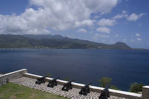
At its height, Fort Shirley spanned over 200 acres
within the Cabrits peninsula, comprising more than 50 stone
buildings—including barracks, officers’ quarters, powder magazines,
and seven gun batteries mounting 35 cannons. The fort’s design
leveraged the twin volcanic hills, with batteries positioned to
command the bay and inland approaches. Enslaved Africans and local
laborers built the fort under harsh conditions, their work evident
in the sturdy limestone and volcanic rock walls that endure today.
By 1802, over 600 troops were stationed there, making it one of
Britain’s largest Caribbean garrisons, alongside smaller outposts
like the Douglas Bay Battery.
The fort saw action during the
Napoleonic Wars, notably repelling a French attack in 1805, but its
military role waned after the 1815 Treaty of Paris stabilized
British dominance. As steamships replaced sail and sugar declined,
Fort Shirley was abandoned in 1854, its cannons silenced and
buildings left to the encroaching jungle. The British withdrawal
marked the end of its active military history, though its ruins
remained a silent witness to Dominica’s colonial past.
For over a century after its abandonment, Fort Shirley and the
Cabrits peninsula fell into obscurity, overtaken by rainforest
vegetation. The site’s isolation—accessible only by boat or rough
trails—preserved its structures from looting or development, though
hurricanes and tropical decay took a toll. Local communities in
Portsmouth used the surrounding waters for fishing and the land for
small-scale farming, but the fort itself was largely forgotten, its
cannons rusting amid creeping vines.
In the 20th century,
Dominica’s push toward independence—achieved on November 3,
1978—sparked renewed interest in its heritage. Historian Lennox
Honychurch, a Dominican scholar, began advocating for the Cabrits’
preservation in the 1970s, recognizing Fort Shirley’s historical
value. His efforts, coupled with growing eco-tourism interest in
Dominica’s pristine landscapes, led to the area’s designation as a
national park in 1986 under the National Parks and Protected Areas
Act. The park’s creation aimed to protect both its natural and
cultural assets, encompassing the peninsula, adjacent wetlands, and
a marine reserve in Prince Rupert Bay.
Restoration of Fort Shirley began in the 1990s, spearheaded by
Honychurch and funded by the Dominican government, UNESCO, and
private donors like the Cabrits Trust Fund. Initial efforts cleared
overgrown vegetation, revealing the fort’s layout—officers’ quarters
with panoramic views, a restored powder magazine, and several
cannons repositioned on their mounts. By 2004, seven buildings were
fully restored, including the Officers’ Quarters, now a visitor
center with exhibits on the fort’s history and Kalinago artifacts.
The project employed local masons, blending traditional techniques
with modern conservation, earning praise as a model of heritage
restoration.
The park’s broader ecosystem also gained
attention. The Cabrits Swamp, a brackish wetland at the peninsula’s
base, supports mangroves and migratory birds, while the marine
reserve—home to coral reefs and sea turtles—extends its ecological
reach. In 2006, the Waitukubuli National Trail’s Segment 14 was
routed through the park, ending at Fort Shirley, cementing its
status as a hiking destination. Cruise ship tourism boosted
visitation, with 10,000–15,000 annual visitors by the 2010s, drawn
by boat trips from Portsmouth and guided tours.
Hurricane
Maria in September 2017, a Category 5 storm, severely damaged the
park, toppling trees, flooding the swamp, and scattering debris
across Fort Shirley. Restoration efforts resumed swiftly, with
voluntourism and government funding repairing trails and structures
by 2020. As of 2025, the park thrives, hosting events like the
annual Cabrits Jazz Festival (launched post-Maria) and offering
trails to West and East Cabrit peaks, where hikers enjoy 360-degree
views of Dominica’s north coast and Guadeloupe on clear days.
Cabrits National Park is situated at approximately 15.58°N latitude
and 61.47°W longitude, on Dominica’s northwestern tip, about 25 miles
(40 kilometers) north of the capital, Roseau. The park lies on a
peninsula known as the Cabrits, which juts into Prince Rupert Bay, one
of the Caribbean’s finest natural harbors. This bay, sheltered by the
peninsula and the mainland, stretches 2 miles (3.2 kilometers) wide and
serves as a vital anchorage for ships, historically and today. The
park’s northern boundary aligns with the island’s coastline, facing the
Dominica Channel, with views of Guadeloupe, 25 miles (40 kilometers)
away on clear days. To the south and east, it borders Portsmouth,
Dominica’s second-largest town, while the west opens to the Caribbean
Sea.
The park’s position near the northern terminus of the
Waitukubuli National Trail (Segment 14) ties it into Dominica’s broader
network of natural attractions, connecting it to inland rainforests and
volcanic peaks like Morne Diablotins, 10 miles (16 kilometers)
southeast. Its coastal setting contrasts with the island’s mountainous
interior, making it a unique ecological and scenic outlier.
The Cabrits peninsula is dominated by two volcanic domes, remnants of
Dominica’s geologically active past:
West Cabrit: Rising to 560 feet
(171 meters) above sea level, this is the taller and more prominent
peak, offering panoramic views of Prince Rupert Bay and the Caribbean
Sea.
East Cabrit: Slightly lower at 460 feet (140 meters), it
complements its twin, creating a distinctive double-humped silhouette
visible from Portsmouth.
These hills, formed by volcanic
eruptions millions of years ago during the Miocene epoch, are part of a
larger volcanic complex that shapes Dominica’s rugged landscape. The
peninsula extends roughly 1 mile (1.6 kilometers) north-south and 0.5
miles (0.8 kilometers) east-west, connected to the mainland by a narrow
isthmus that widens into a low-lying swamp. The terrain slopes steeply
from the peaks to the coast, with rocky cliffs dropping into the sea on
the northern and western edges, while gentler inclines lead to the swamp
and bay on the south and east.
Fort Shirley, the park’s historic
centerpiece, occupies a saddle between the two hills at about 150–200
feet (45–60 meters) elevation, its stone structures blending into the
volcanic rock. Trails wind up both peaks, with the West Cabrit trail
offering a strenuous 45-minute climb to a lookout tower, while East
Cabrit’s path is shorter but equally rewarding, both revealing the
park’s dramatic topography.
The park’s coastline is a mix of rugged cliffs and sheltered bays:
Northern and Western Shores: Steep, rocky cliffs plunge into the
Caribbean Sea, fringed by narrow black sand beaches formed from volcanic
ash and basalt. These shores are exposed to ocean swells, limiting
swimming but offering dramatic vistas.
Eastern Shore: Facing Prince
Rupert Bay, the coastline softens into a gentle curve, with calmer
waters ideal for kayaking and snorkeling near the marine reserve.
The Cabrits Marine Reserve, encompassing 1,053 acres (426 hectares)
of the park’s total area, extends offshore from the peninsula’s western
and northern edges. This underwater zone features vibrant coral
reefs—branching and brain corals—teeming with tropical fish (parrotfish,
sergeant majors), sea turtles, and occasional dolphins. The bay’s depth
reaches 60–100 feet (18–30 meters), dropping off sharply beyond the
reefs, while shallow areas near the shore host seagrass beds and marine
nurseries. The reserve’s boundary aligns with Douglas Bay to the north,
enhancing its ecological connectivity.
The Cabrits Swamp, a brackish wetland at the peninsula’s base, spans the isthmus linking it to the mainland. Covering about 20–30 acres (8–12 hectares), this low-lying area—barely above sea level—floods seasonally, blending freshwater runoff from the hills with tidal saltwater from the bay. Mangroves (Rhizophora mangle and Avicennia germinans) dominate, their tangled roots stabilizing the swamp and supporting a rich ecosystem of crabs, fish, and wading birds like herons and egrets. The swamp’s muddy expanse contrasts with the park’s uplands, acting as a natural buffer and biodiversity hotspot.
Cabrits National Park showcases Dominica’s ecological diversity
across its varied zones:
Dry Scrub Forest: The hillsides, exposed to
coastal winds and less rainfall, feature drought-resistant
vegetation—cacti, acacias, logwood, and sea grape trees. This contrasts
with the island’s wetter interior rainforests.
Rainforest Pockets:
Shaded ravines and northern slopes host wetter microclimates, with
mahogany, gommier, and giant ferns, draped in vines and epiphytes like
bromeliads.
Wetlands: Mangroves and swamp grasses thrive in the
brackish isthmus, interspersed with wildflowers and sedges.
Coastal
Vegetation: Coconut palms and sea almonds line the bay’s edge, adding a
tropical flair.
The park’s biodiversity includes over 50 bird
species—Sisserou parrots, hummingbirds, frigatebirds—alongside iguanas,
anole lizards, and land crabs. The marine reserve adds sea turtles,
rays, and reef fish, making Cabrits a compact yet rich ecological
tapestry.
Cabrits National Park experiences a tropical rainforest climate
(Köppen Af), moderated by its coastal location:
Temperature: Averages
75–85°F (24–29°C) year-round, with cooler nights on the hills (70–75°F
or 21–24°C).
Rainfall: Annual precipitation ranges from 60–80 inches
(1,500–2,000 mm), lower than Dominica’s interior (up to 300 inches), due
to a partial rain shadow from Morne Diablotins. The wet season
(June–November) brings heavy showers, while the dry season
(December–May) offers clearer skies.
Winds: Trade winds from the
northeast buffet the cliffs, tempering humidity and shaping the scrub
forest.
Hurricanes, like Maria in 2017, occasionally reshape the
landscape, felling trees and flooding the swamp, though recovery is
swift in this resilient ecosystem.
The park’s layout integrates natural and historical features:
Fort
Shirley: Nestled between the hills, the restored 18th-century British
fort includes stone buildings, cannons, and trails, covering 200 acres
of the terrestrial zone.
Trails: The Waitukubuli National Trail
(Segment 14) ends here, with paths to West and East Cabrit peaks (1–2
hours round-trip) offering rugged hikes and scenic overlooks.
Access:
Entry is via Portsmouth, with a short boat ride from Indian River or a
15-minute walk from town to the park’s southern gate near the swamp. A
visitor center at Fort Shirley provides maps and exhibits.
The
park’s isolation—no roads penetrate the peninsula—preserves its
wildness, though a jetty at the bay facilitates cruise ship access.
The national park has a network of walking trails and the final stage of the Waitukubuli Trail (segment 14) runs from Capuchin to Cabrits.[2] There are also guided tours for tourists. There is a jetty and a diving school on the southern coast.