The Waitukubuli National Trail (WNT) in Dominica is an extraordinary long-distance hiking trail, renowned as the Caribbean’s first and longest of its kind, stretching approximately 115 miles (185 kilometers) from the southern tip of the island at Scott’s Head to the northern end at Cabrits National Park. Named after the indigenous Kalinago (Carib) word for Dominica, meaning “tall is her body,” the trail embodies the island’s rugged, mountainous terrain and rich cultural heritage. Spanning 14 distinct segments, it traverses a diverse landscape of lush rainforests, volcanic peaks, cascading waterfalls, coastal cliffs, and historic sites, offering hikers an unparalleled journey through Dominica’s natural and human history. As of April 10, 2025, the WNT remains a crown jewel of eco-tourism, managed by the Forestry, Wildlife and Parks Division, drawing adventurers from around the world to explore the “Nature Island” in its rawest form.
The WNT is a meticulously designed trail that snakes
across Dominica’s 290-square-mile expanse, weaving through its varied
topography from sea level to elevations exceeding 4,700 feet (1,447
meters) at Morne Diablotins, the island’s highest peak. Divided into 14
segments, each averaging 6–10 miles (10–17 kilometers), the trail can
take 10–14 days to complete end-to-end, depending on pace and rest days.
Each segment offers a unique experience, rated from easy to very
difficult, catering to hikers of all abilities while showcasing the
island’s ecological diversity and cultural landmarks.
Segment 1:
Scott’s Head to Soufriere Estate (7 km, Challenging)
Starting at the
southern coastal village of Scott’s Head, this segment climbs through
volcanic landscapes, passing sulphur springs and the historic Soufriere
Estate, with views of the Caribbean Sea.
Segment 2: Soufriere Estate
to Bellevue Chopin (12 km, Intermediate)
A mix of coastal paths and
inland hills, this section features farmland and glimpses of the old
French Quarter.
Segment 3: Bellevue Chopin to Wotten Waven (13 km,
Intermediate)
Hikers ascend into rainforest terrain, encountering hot
springs and the village of Wotten Waven, known for its geothermal
activity.
Segment 4: Wotten Waven to Pont Cassé (13 km,
Intermediate-Challenging)
This segment crosses dense forest and
rivers, ending at Pont Cassé, a central hub near the trail’s
headquarters.
Segment 5: Pont Cassé to Castle Bruce (17 km,
Intermediate-Challenging)
A descent through rainforest to the east
coast, passing the Emerald Pool and ending in Castle Bruce.
Segment
6: Castle Bruce to Hatten Garden (14 km, Intermediate)
Traversing the
Kalinago Territory, this coastal stretch offers cultural immersion and
scenic beaches.
Segment 7: Hatten Garden to First Camp (9 km,
Intermediate)
A shorter climb into the interior, featuring woodland
hills and rural vistas.
Segment 8: First Camp to Petite Macoucherie
(14 km, Challenging)
One of the toughest segments, it crosses primary
forest and Morne Arney, ending on the west coast.
Segment 9: Petite
Macoucherie to Colihaut Heights (13 km, Challenging)
Another
demanding leg through steep rainforest, connecting to Colihaut Heights.
Segment 10: Colihaut Heights to Syndicate (7 km, Easy)
An easier
coastal walk past farmland and parrot habitats, ending at the Syndicate
Nature Reserve.
Segment 11: Syndicate to Bourne (13 km, Challenging)
Climbing into the volcanic Morne Diablotins foothills, this segment is
remote and rugged.
Segment 12: Bourne to Penville (13 km,
Intermediate)
A mix of forest and farmland, descending toward the
northern coast.
Segment 13: Penville to Capuchin (7 km, Intermediate)
Coastal cliffs and fishing villages mark this northern stretch.
Segment 14: Capuchin to Cabrits National Park (10 km, Intermediate)
Ending at the historic Cabrits National Park, this segment features
black sand beaches and Fort Shirley.
The trail’s surface is
mostly soil, with some rocky sections, marked by yellow and blue blazes,
directional signposts, and occasional map boards. Its sinuous route—far
exceeding Dominica’s 28-mile length—reflects its traversal of ridges,
valleys, and spurs, maximizing exposure to the island’s wonders.
The WNT’s origins trace to the 1990s, when Dominican
lawyer Bernard Wiltshire, inspired by the UK’s Offa’s Dyke Path,
envisioned a trail to connect Dominica’s pre-existing paths—Kalinago
trails, Maroon escape routes, and colonial tracks—into a unified route.
The Waitukubuli Ecological Foundation, founded by Wiltshire, championed
the idea, securing funding from the European Union, the Regional Council
of Martinique, the Dominican government, and local stakeholders.
Construction began in 2007, led by pioneers like Michael Eugene, who
spent 18 months mapping and describing the segments. Partially opened in
2011, the trail was fully inaugurated on May 10, 2013, at the Pond Cassé
Reception Center, designated an eco-tourist site under the Forestry
Division.
The trail’s name honors the Kalinago people, who
inhabited Dominica before European contact in 1493, reflecting its
passage through their ancestral lands and villages. It also traverses
sites tied to 18th-century French settlements, British forts like Fort
Shirley, and Maroon hideaways, weaving a historical narrative into the
physical journey. Hurricane Maria, a Category 5 storm in September 2017,
devastated the trail, felling trees and triggering landslides, but
voluntourism and local efforts restored most segments by the early
2020s, reinforcing its resilience.
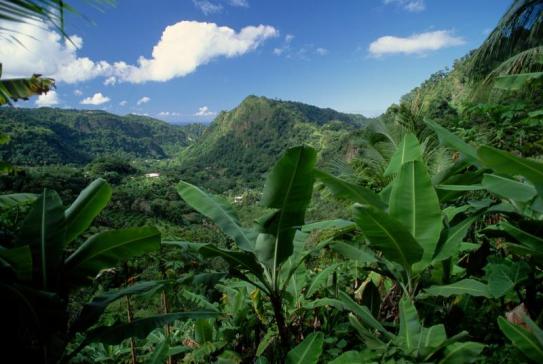
Dominica’s nickname, “Nature Island,” comes alive on the WNT. The
trail spans multiple ecosystems:
Rainforests: Dense, humid
forests dominate, with mahogany, gommier, and giant ferns, home to
parrots, hummingbirds, and the rare Sisserou parrot (Dominica’s
national bird).
Volcanic Terrain: Segments near Morne Diablotins
and the Boiling Lake (accessible via spurs) reveal steaming sulphur
springs, hot pools, and volcanic rock.
Waterfalls and Rivers:
Highlights include Middleham Falls, Trafalgar Falls, and countless
river crossings, with clear pools for dipping.
Coastal Cliffs:
Northern and southern ends feature dramatic ocean views, black sand
beaches, and marine reserves.
Elfin Woodland: High elevations
host stunted, moss-draped trees, a stark contrast to lowland
jungles.
The absence of venomous snakes or dangerous
wildlife—only harmless boas, lizards, and iguanas—makes the trail
uniquely safe, though mosquitoes and humidity pose challenges. The
trail’s biodiversity earned it accolades, including National
Geographic’s “Top 10 North American Hikes of a Lifetime” in 2020 and
Lonely Planet’s “Top 5 Caribbean Hikes” in 2023.
Hiking the WNT requires preparation and a trail pass: $12 USD for a
day pass, $40 USD for a 15-day pass, available at Forestry Division
offices or online (waitukubulitrail.dm). Registration is mandatory for
safety, given the trail’s remoteness—some segments lack phone
service—and guides are recommended for challenging sections like 8 and
9. The dry season (December–May) is ideal, with temperatures of 75–85°F
(24–29°C) and clearer paths, though the rainy season (June–November)
offers lush scenery despite mud and potential closures.
The full
trail is a thru-hiker’s dream, taking 12–14 days with a pack (30–40 lbs
recommended), though day hikes of single segments are popular. Camping
is prohibited in national parks to protect ecosystems, but eco-lodges,
guesthouses (e.g., Hibiscus Valley Inn), and homestays in villages like
Pont Cassé and Kalinago Territory provide lodging. Hikers pack sturdy
boots, water shoes, insect repellent, and waterproof gear, with 2–3
liters of water per day essential due to sparse sources. Highlights
include swimming in river pools, tasting wild fruits like mangoes, and
meeting locals who share stories and fresh coconut water.
The WNT is a cultural corridor, linking 32 communities and historic sites. Passing through Kalinago Territory (Segment 6), hikers engage with the indigenous people’s crafts and traditions, while Fort Shirley (Segment 14) recalls British colonial defenses. Maroon trails evoke the resistance of enslaved Africans, and old plantations hint at the island’s agricultural past. This blend of nature and heritage makes the WNT a journey through Dominica’s soul, celebrating its resilience and diversity.