Tel. 876-920-8278
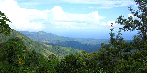
The Blue Mountains of Jamaica are a majestic and expansive mountain range that dominate the eastern third of the island, forming a rugged backbone of breathtaking landscapes, rich biodiversity, and cultural significance. Stretching across four parishes—St. Andrew, St. Thomas, Portland, and St. Mary—they encompass some of Jamaica’s most iconic natural features, including the nation’s highest peak, Blue Mountain Peak, which rises to 7,402 feet (2,256 meters) above sea level. Renowned for their misty, blue-hazed vistas, lush rainforests, and world-famous coffee, the Blue Mountains are a UNESCO World Heritage Site (since 2015, as part of the Blue and John Crow Mountains National Park) and a cherished jewel of the Caribbean. As of April 10, 2025, they remain a haven for hikers, nature lovers, and those seeking to explore Jamaica’s ecological and historical depths.
The Blue Mountains span approximately 45 miles (72
kilometers) in length and vary in width from 12 to 20 miles (19 to 32
kilometers), covering an area of roughly 300 square miles (777 square
kilometers). They rise sharply from the coastal plains of eastern
Jamaica, transitioning from sea level to their towering heights within a
short distance, creating a dramatic escarpment that defines the region’s
geography. The range’s highest point, Blue Mountain Peak, sits in the
central spine, offering panoramic views stretching to the Caribbean Sea
on clear days—and, legend claims, as far as Cuba, 90 miles north, under
perfect conditions.
The terrain is rugged and varied,
characterized by steep slopes, deep valleys, and knife-edge ridges
formed by millions of years of tectonic uplift and erosion. The
mountains are part of the Caribbean Plate, uplifted during the Miocene
epoch (23–5 million years ago) when the North American Plate collided
with it, folding and faulting the limestone and shale bedrock.
Subsequent weathering sculpted the peaks and gorges, with rivers like
the Rio Grande, Yallahs, and Buff Bay carving steep-sided valleys that
plunge toward the coast. The western slopes, facing Kingston, are
gentler, while the eastern and northern faces drop precipitously into
rain-soaked forests and coastal plains, contributing to the range’s
mystique.
The “blue” in their name comes from the ethereal haze
that cloaks the peaks, a result of volatile organic compounds released
by the dense vegetation, refracting sunlight to create a bluish tint.
This phenomenon is most striking at dawn or dusk, when the interplay of
mist and light transforms the landscape into a dreamlike vista.
The Blue Mountains’ elevation creates a distinct
microclimate, cooler and wetter than Jamaica’s coastal lowlands.
Temperatures at higher altitudes average 55°F to 65°F (13°C to 18°C)
year-round, dropping as low as 40°F (4°C) at night on the peak—a stark
contrast to the 80°F to 90°F (27°C to 32°C) heat of Kingston, just 20
miles southwest. Rainfall is abundant, with annual totals exceeding 200
inches (5,000 mm) on the northern slopes, fed by the northeast trade
winds that dump moisture as they rise over the range. The southern
slopes, in the rain shadow, receive less—around 80 inches (2,000 mm)—but
still support lush growth.
The wet season peaks from May to
November, often aligning with hurricane season (June–November), bringing
heavy downpours and occasional landslides. The dry season, December to
April, offers clearer skies and milder conditions, ideal for hiking and
coffee harvesting. Fog and mist are near-constant companions above 3,000
feet, shrouding the peaks in an otherworldly ambiance that enhances
their allure but can challenge visibility for trekkers.
The Blue Mountains are a biodiversity hotspot, hosting
one of the richest ecosystems in the Caribbean. Their forests range from
lowland tropical rainforest below 3,000 feet to montane cloud forest
above, with elfin woodland—stunted, moss-draped trees—crowning the
highest ridges. Over 800 plant species thrive here, nearly half of
Jamaica’s native flora, including 270 endemic flowering plants. Notable
among them are towering mahogany and blue mahoe trees (the latter
Jamaica’s national tree), giant tree ferns, wild orchids, and bromeliads
that cling to branches. The upper slopes feature unique species like the
Chusquea abietifolia, a bamboo-like grass, and the Pittosporum
undulatum, an invasive yet striking shrub.
Wildlife is equally
diverse, with over 200 bird species, including 30 endemics. The Jamaican
tody, a tiny, jewel-like bird with a red throat and green back, flits
through the canopy, while the rare Jamaican blackbird and the vibrant
red-billed streamertail (the “doctor bird,” Jamaica’s national bird) add
splashes of color. The mountains are also home to the world’s
second-largest butterfly, the giant swallowtail (Papilio homerus), with
a wingspan up to 6 inches, found only in these forests and Cockpit
Country. Mammals are scarcer, but the Jamaican coney (a rodent-like
hutia) and introduced mongooses roam the undergrowth, alongside frogs
like the melodious Jamaican snoring frog.
The Blue Mountains’ limestone and shale foundation
supports a network of rivers and waterfalls that drain into both the
northern and southern coasts. The Rio Grande, one of Jamaica’s longest
rivers, originates here, winding 21 miles through Portland parish to the
sea, once used to raft coffee barrels downstream. Smaller streams feed
spectacular falls like Reach Falls and Somerset Falls on the northern
slopes, their clear pools inviting swimmers amid lush settings. Springs
bubble up from the karst landscape, their mineral-rich waters sustaining
the coffee plantations that dot the lower elevations.
The range’s
geology also influences its coffee production. Volcanic ash and loamy
soils, enriched by millennia of decomposition, create ideal conditions
for Coffea arabica, yielding the globally prized Blue Mountain Coffee.
Grown between 2,000 and 5,000 feet, this coffee benefits from the cool,
misty climate and well-drained slopes, a synergy of nature and
agriculture unique to the region.
The Blue Mountains have long been a cultural and
historical touchstone. Before European contact, the indigenous Taíno
(Arawak) revered the peaks as sacred, calling the island “Xaymaca” (land
of wood and water) for its abundant resources. After Spanish
colonization in 1494 and British takeover in 1655, the mountains became
a refuge for enslaved Africans who escaped plantations. These Maroons
established autonomous communities in the rugged interior, notably in
the Blue and John Crow Mountains, where leaders like Nanny of the
Maroons waged guerrilla warfare against the British. The 1739 peace
treaty with the Maroons granted them autonomy, and their descendants
still inhabit villages like Moore Town, preserving traditions like
drumming and herbal medicine.
In the 19th century, British
planters exploited the lower slopes for coffee, importing labor to clear
forests and build estates like Craighton and Clifton Mount—some still
operational today. The mountains’ inaccessibility preserved their
wildness, a quality that earned them UNESCO status in 2015 for both
natural and cultural heritage, recognizing the Maroon legacy alongside
ecological value.
Visiting the Blue Mountains offers a mix of adventure
and tranquility. The most popular activity is hiking to Blue Mountain
Peak, a 6-mile (10-km) round-trip trail from Abbey Green or Penlyne
Castle, typically starting at midnight to catch sunrise at 5:30–6 a.m.
The 7-hour trek ascends 3,000 feet through misty forests, with guides
from local communities like Mavis Bank providing expertise for $20–$40.
The summit rewards with 360-degree views—Kingston’s lights to the south,
the north coast’s beaches, and endless peaks—though fog often shrouds
the scene, adding mystique.
Other sights include Holywell
Recreation Area, a park at 4,000 feet with trails, picnic spots, and
cabins offering vistas of Kingston and rare bird sightings. Cinchona
Botanical Gardens, a historic site at 5,500 feet, features exotic plants
like azaleas and camellias, planted by British colonials in the 1860s,
though its buildings are weathered. Coffee plantation tours at estates
like Old Tavern or Mavis Bank Coffee Factory reveal the bean-to-cup
process, often with tastings of the smooth, low-acidity brew.
Access is via winding roads from Kingston (1–2 hours to trailheads) or
Papine, with 4WD recommended for steep, potholed routes like the B1.
Public minibuses from Kingston reach Mavis Bank, but private tours
($100–$150) offer convenience.