Location: Map
Area: 40 acres
Lucayan National Park, located on Grand Bahama Island in The Bahamas, is a 40-acre (16-hectare) ecological and historical gem that encapsulates the natural beauty and cultural heritage of the region. Established in 1982 and managed by the Bahamas National Trust, the park is celebrated for its diverse ecosystems, one of the world’s longest charted underwater cave systems, and its pristine Gold Rock Beach. Situated approximately 25 miles (40 kilometers) east of Freeport along the Grand Bahama Highway, it is a standout among the island’s three national parks, offering visitors a unique blend of adventure, tranquility, and education.
Lucayan National Park’s 40 acres are a microcosm of The Bahamas’ ecological diversity, encompassing all six of the country’s vegetative zones: pine forest, hardwood coppice, mangrove swamp, whiteland, blackland, and coastal scrub. This compact yet varied terrain is bisected by Gold Rock Creek, a tidal mangrove creek that connects inland freshwater systems to the ocean about 2 miles (3.2 kilometers) east. The park’s layout is divided into two main sections by the highway, each offering distinct experiences.
The northern side, accessible from the main parking
area, features the park’s most famous attractions: Ben’s Cave and Burial
Mound Cave. These limestone caverns are part of a sprawling underwater
cave system with over 6.4 miles (10.3 kilometers) of charted tunnels—one
of the longest in the world. Formed by the erosion of Grand Bahama’s
porous limestone bedrock, the caves contain pools of fresh water atop
denser saltwater layers, creating a stratified aquatic environment.
Wooden boardwalks and spiral staircases lead visitors down to viewing
platforms above the caves, where the still, clear waters reflect the
rocky ceilings adorned with stalactites.
Ben’s Cave is a
sanctuary for tiny buffy flower bats, their faint chirps echoing in the
dim light, while Burial Mound Cave holds archaeological significance as
the site where skeletal remains of six Lucayan Indians were discovered
in 1986, alongside artifacts like pottery. Swimming is prohibited to
protect these fragile ecosystems, and diving requires a special permit
from the Bahamas National Trust, reserved for scientific exploration due
to the caves’ delicate conditions and submerged tunnels.
Nature
trails wind through this section, a short 15–20-minute loop through pine
forests and coppice, lined with interpretive signs detailing the
flora—palms, wild orchids, and ferns—and fauna, including birds like the
Bahama swallow and olive-capped warbler. The trails are flat and
well-maintained, offering a shady respite beneath towering Caribbean
pines and glimpses of raccoons or butterflies flitting among the
undergrowth.
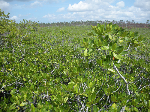
Across the highway, a boardwalk extends south through
a mangrove swamp, where tangled roots of red and black mangroves rise
from the brackish waters of Gold Rock Creek. This 10–15-minute walk,
shaded by the canopy, reveals a thriving ecosystem—crabs scuttle along
the mud, and wading birds like snowy egrets forage in the shallows. The
boardwalk ends at Gold Rock Beach, a pristine stretch of white sand and
turquoise water often hailed as Grand Bahama’s most beautiful shore.
At low tide, Gold Rock Beach widens dramatically, exposing tidal
pools and a rippled “Welcome Mat” of sand, a natural feature that
inspired its use in Pirates of the Caribbean: Dead Man’s Chest and The
Curse of the Black Pearl. The beach’s seclusion—far from Freeport’s
crowds—and shallow, calm waters make it ideal for wading or picnicking
at tables near the shore, though raccoons may pilfer unattended snacks.
The coastal scrub and dunes behind the beach add a wild, untouched
charm, with sea grapes and low shrubs framing the scene.
Lucayan National Park’s name honors the Lucayan
Indians, The Bahamas’ indigenous Arawak people who inhabited the islands
from around 600 AD until Spanish contact in 1492 decimated their
population through disease and enslavement. The caves served as
freshwater sources and ceremonial burial sites, with the low-oxygen
environment preserving their remains and artifacts remarkably well. The
1986 discovery in Burial Mound Cave, carbon-dated by the Smithsonian
Institute, confirmed their presence on Grand Bahama, linking the park to
pre-Columbian history.
The park’s modern history began in the
late 1970s when biologist Jim Popenoe discovered a new class of
crustacean, Remipedia (Speleonectes lucayensis), in Ben’s Cave—a blind,
centipede-like creature adapted to the dark, submerged caverns. This
find spurred conservation efforts, leading to the Bahamas National
Trust’s 99-year lease of the land from the Grand Bahama Development
Company in 1982. Initially closed to recover from human impact, the park
reopened in 1985 with boardwalks and trails built by Operation Raleigh,
a youth initiative under Prince Charles’ patronage. Expanded in 2015, it
now ranks as The Bahamas’ second-most visited national park, supporting
local livelihoods through tourism.
Lucayan National Park is open daily from 9 a.m. to 5
p.m., with an admission fee of $12 USD for adults, $6 USD for children
under 13, and $9 USD for seniors (60+), payable at the entrance or Rand
Nature Center in Freeport. Located 18 miles (29 kilometers) northeast of
Freeport’s cruise port, it’s a 30–40-minute drive via taxi ($40–$60 USD
round-trip) or rental car, with parking at the northern entrance. Guided
tours, like those from Bahamas EcoVentures, enhance the experience
($30–$50 USD), though self-guided visits are common.
The northern
loop takes 20–30 minutes, offering a quick but fascinating look at the
caves and forest, while the southern boardwalk to Gold Rock Beach adds
another 20–30 minutes round-trip. Total visit time ranges from 1–3
hours, or longer with a beach picnic—bring swimsuits, sunscreen, and
water, as facilities are limited to rustic restrooms near the entrance
and no concessions. The dry season (November–April) is ideal, with
temperatures of 75–85°F (24–29°C) and less rain, though the wet season
(May–October) showcases lusher greenery despite occasional showers.
Ecologically, the park is a biodiversity haven,
protecting all Bahamian vegetative zones and rare species like the
Remipedia and buffy flower bats. Its mangroves filter water and nurture
marine life, while the pine forests and beach dunes stabilize the
landscape. As an Important Bird Area, it hosts migratory and endemic
birds—thick-billed vireos, Cuban emeralds—drawing birdwatchers,
especially in winter (October–May).
Culturally, it preserves
Lucayan heritage, offering a tangible link to The Bahamas’ first
inhabitants. Its caves and beach also tie into modern lore, from
scientific discovery to Hollywood fame, enhancing its allure. The park’s
conservation efforts, balancing tourism with ecological protection, make
it a model of sustainable stewardship.