Location: Map
Area: 13,838 acres
Parque Nacional Volcán Poás is one of Costa Rica’s most iconic and accessible national parks, centered around the active Poás Volcano, a stratovolcano rising to 2,697–2,708 meters (8,848–8,885 feet) in the Central Volcanic Range of Alajuela Province. Established on January 25, 1971, the park spans 6,500 hectares (16,000 acres) and is renowned for its massive crater, vibrant crater lakes, and surrounding cloud forests. Located just 37 km north of Alajuela and 50–68 km from San José, its proximity to the capital makes it a popular day trip, drawing thousands for its geothermal wonders and biodiversity.
Parque Nacional Volcán Poás lies within the Central Conservation Area
(ACCVC), part of the Cordillera Volcánica Central, near Costa Rica’s
Pacific coast. The park’s centerpiece, Poás Volcano, is one of the
country’s five active volcanoes, located at coordinates approximately
10°12′N, 84°14′W. Its accessibility—via paved roads from Alajuela or
Heredia—contrasts with its high-altitude, often cloud-shrouded
environment, where temperatures can drop below freezing.
Geographical Features
Main Crater (Laguna Caliente): The active
crater, one of the world’s largest, measures 1.5 km (0.9 miles) wide and
300 meters (984 feet) deep. It contains a turquoise, acidic lake (pH
near zero) fed by rainwater, heated geothermally, and surrounded by
fumaroles emitting sulfur dioxide, sulfuric acid, hydrochloric acid, and
carbon dioxide. Geysers can erupt up to 250 meters (820 feet) when steam
pressure builds.
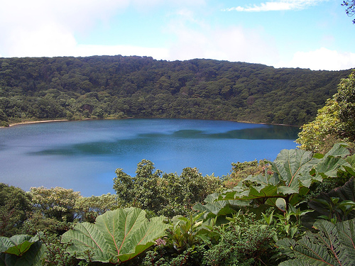
Botos Lagoon: An inactive crater lake, 370 meters
(1,200 feet) in diameter, filled with cold, green rainwater. Last active
7,500 years ago, it drains into the Caribbean via the Río Ángel, a
tributary of the Sarapiquí River.
Von Frantzius Crater: An extinct
crater, less visited, adding to the park’s volcanic diversity.
Surrounding Volcanoes: Nearby inactive volcanoes include Chompipe (2,259
m), Turu (2,139 m), Cerro Cacho Negro (2,250 m), and Barva’s Tres Marías
(1,725 m).
Geological Activity
Poás is a stratovolcano formed
by subduction in the Central American Volcanic Arc, with eruptions
recorded 40 times since 1828. Notable events include:
1910: A
massive eruption ejected nearly 1 million tons of ash, with a column of
smoke and steam.
1952–1954: The last period of violent eruptive
activity.
2009: Minor phreatic eruptions and landslides followed a
6.1-magnitude earthquake near Cinchona, killing 40.
2014: A webcam
captured a 1,000-foot ash cloud on February 25.
2017: A strong
eruption on April 12–16 spewed gas, ash, and rocks, damaging
infrastructure and closing the park for 17 months. A 4-km ash column on
April 21 was the tallest since 2017.
2019: Eruptions on February 11
(200-m ash column) and September 30 (2-km column) prompted temporary
closures.
2022–2023: Increased activity, including phreatic eruptions
(e.g., March 30, 2023, 150-m ejection), led to intermittent closures,
with a 200-m ash column reported on March 28, 2023.
The Deep Earth
Carbon Degassing Project and OVSICORI-UNA monitor Poás, reporting 844
tons/day of sulfur dioxide in 2023, with extreme levels affecting
visitors and nearby communities. The park’s Alert Level 3 (second
highest) and Aviation Color Code Orange reflect ongoing risks, including
potential lahars in drainages like Río Poasito. The International Union
of Geological Sciences (IUGS) designated Poás an IUGS Geological
Heritage Site in October 2022 for its exemplary arc shield-like
stratovolcano and active crater lake complex.
Environmental
Impact
The volcano’s emissions cause acid rain, stunting vegetation
around the caldera and downwind, creating a barren, brown-black
landscape. This contrasts with the lush cloud forests at lower
elevations, highlighting the volcano’s extreme ecological influence.
The park’s diverse habitats—cloud forests, montane rainforests, and
barren volcanic zones—support a unique ecosystem with high endemism,
though biodiversity is lower than in lowland parks. Its role in
protecting watersheds, including the Río Sarapiquí (Caribbean) and Río
Grande de Tárcoles (Pacific), is critical for regional water supply.
Flora
Vegetation varies by altitude:
2,400–2,500 m: 79
species, dominated by oaks (Quercus costaricensis, Q. seemannii),
cypresses (Podocarpus oleifolius), magnolias (Magnolia poasana), Ocotea,
and Weinmannia pinnata. Trees have narrow crowns and straight trunks.
Endemic Species: Gunnera insignis (“poor man’s umbrella” with large,
perforated leaves), Archibaccharis jacksonii, Hydrocotyle torresiana,
Oreopanax nubigenus, Miconia biperulifera, Cestrum poasanum, Solanum
longiconicum, and Mahonia paniculata.
Threatened Species: Orchids
(Acineta chrysantha, Epidendrum polyclamys, Masdevallia chontalensis)
and ferns (Blechnum sessilifolium).
Cloud Forests: Near Botos Lagoon,
bromeliads, orchids, and mosses thrive in humid conditions, though
deforestation has reduced forest extent due to agriculture and
settlements.
Fauna
The park hosts 40 mammal species, numerous
birds, and reptiles, with notable endemism:
Mammals: Poás squirrel
(endemic), marmots, rabbits, coyotes, red brocket deer, and small bats.
Large predators like jaguars are rare.
Birds: Over 100 species,
including resplendent quetzal, black guan, clay-colored robin (Costa
Rica’s national bird), hummingbirds (e.g., Lesser Violetear, Brown
Violetear), tanagers, flycatchers, toucans (Northern Emerald-Toucanet),
Prong-billed Barbet, Bare-shanked Screech-Owl, and Band-tailed Pigeon.
The park is part of the Costa Rica-Panama Highlands Endemic Bird Area.
Reptiles: Helmeted Iguana, Black Spiny-tailed Iguana, Emerald Swift,
Central American Eyelash-Viper, and other snakes.
Amphibians: Limited
data, but likely includes small frogs.
Microorganisms: The acidic
Laguna Caliente supports Acidiphilium, a sulfur-oxidizing bacterium of
interest for Mars research due to its extremophile nature.
Conservation Challenges
Acid Rain: Volcanic emissions damage flora,
reducing forest cover near the crater.
Deforestation: Historical
conversion to pastures and crops outside the park threatens buffer
zones.
Tourism Impact: High visitor numbers (up to 1,000 daily)
strain infrastructure, though strict regulations (e.g., 20-minute crater
visits) mitigate damage.
Conservation Efforts: SINAC enforces online
reservations to limit crowds, and OVSICORI monitors gas levels.
Reforestation and watershed protection ensure ecological stability.
The Poás region is steeped in cultural and historical importance,
reflecting indigenous heritage and Costa Rica’s geological identity.
Indigenous Roots
Pre-Columbian Name: Known as Chibuzú in the
Cabécar language, meaning “mountain of Sibú,” a deity of pre-Columbian
tribes.
Huetar Origin: The name Poás derives from poasi or puasi
(Huetar language), of uncertain meaning, possibly linked to the river or
terrain. Variants include Púas and Puás.
Historical Records: In 1663,
the name Poás referred to lands west of the Río Poás. By 1782, Grecia
and San Pedro de Poás were known as Poás or Púas.
Colonial and
Modern History
Agricultural Hub: The fertile Poás region supports
coffee, strawberry, and flower farms, visible along access roads.
Road Development: Maintenance began in 1914, with the first car ascent
in 1930 (15 days from San Pedro de Poás). A paved road from Heredia to
Puente Grande was built by 1944, and by 1968, the crater was accessible
year-round.
National Park Status: Declared a national park in 1955 by
the Instituto Costarricense de Turismo, formalized in 1971 to protect
the volcano and its ecosystems.
Cultural Symbol
Poás is a
“powerful symbol of the geothermal forces that formed Costa Rica,” as
noted by costa-rica-guide.com. Its accessibility and dramatic crater
make it a cultural touchstone, featured in tourism campaigns and
scientific studies, including NASA’s interest in its acidic lake as a
Mars analog.
Parque Nacional Volcán Poás is one of Costa Rica’s most visited
national parks, attracting adventurers, families, and scientists for its
accessibility and geothermal spectacle. Strict regulations since the
2017 eruption ensure safety but require planning.
Access and
Transportation
Location: 37 km north of Alajuela, 50–68 km from San
José, 72 miles from Ciudad Quesada, and 116 km from La Fortuna.
By
Car:
Route 1: San José to Alajuela, then Route 712 via Itiquís,
Fraijanes, and Poasito (50 km, 1.5 hours). Winding, narrow roads require
caution; no 4x4 needed.
Route 2: San José to Heredia, then Barva,
Varablanca, Poasito (55 km, 1.5–2 hours).
Route 3: San José to
Alajuela, then San Juan, Sabana Redonda, Fraijanes, Poasito.
Scenic
drives pass coffee farms, strawberry stands, and valley views.
Restaurants like Típico de Fraijanes offer local cuisine.
By Public
Transport: Buses from San José to Alajuela (~$1 USD, 30 minutes), then
to Poasito (~$2 USD, 1 hour). From Poasito, taxis (~$10–20 USD) or
hitchhiking to the park entrance. Limited schedules make tours more
reliable.
By Tour: Day trips from San José (~$60–140 USD) include
transport, tickets, and extras like coffee tours or La Paz Waterfall
Gardens. Operators like EcoCircuitos (+506 2482-2165) are recommended.
Best Time: Dry season (December–April), mornings (7–9 AM) for clear
crater views, as clouds often obscure the crater by noon. Wet season
(May–November) risks fog, especially when rainwater reacts with the
acidic lake.
Entrance and Facilities
Cost: $15 USD (adults,
non-residents), $5 USD (children 2–12), ¢1,000 (national adults), ¢500
(national children). Parking: ¢2,000 (cars, ~$3.50), ¢4,000
(minivans/buses), ¢1,000 (motorcycles). Cash only for parking.
Hours:
Open daily 7:00 AM–2:00 PM (last entry 1:20 PM). Visits last 45 minutes,
including a 10-minute paved walk to the crater, 20 minutes at the
overlook, and 10 minutes back.
Reservations: Mandatory via SINAC
website (sinac.go.cr, English option). Create an account with passport
numbers, select “Parque Nacional Volcán Poás,” and choose a 20-minute
timeslot (18 daily, 50 people each). Tickets are non-refundable,
non-changeable, and no-shows forfeit entry. Save confirmation on your
phone due to poor cell service.
Facilities:
Visitor Center:
Wheelchair-accessible, with a museum on volcanic history, café,
restrooms, and gift shop. No potable water; bring your own.
Observation Deck: Paved, accessible platform with crater views, equipped
with gas monitors and concrete bunkers for safety.
Trails: Botos
Lagoon Trail (0.9 miles, 1.4 km, reopened August 2022), a gentle climb
through cloud forest. Escalonia Trail (0.6 miles, 1 km, currently
closed) for birdwatching. Trails are well-marked but weather-dependent.
Safety Measures: Visitors sign a liability waiver acknowledging risks
from toxic gases. Hard hats and guided tours were required until 2022
but are now optional.
Rules:
Arrive 15 minutes early for
check-in.
No refunds for cloud cover or closures due to eruptions.
No touching flora or straying from paths.
Wear layers (temperatures
0–15°C), sunscreen (high UV at altitude), and rain gear.
Activities
Crater Viewing: The main attraction, a 20-minute stop at
the observation deck offers views of Laguna Caliente’s turquoise,
steaming lake and fumaroles. Clear days reveal the crater’s 1.5-km
expanse, though clouds obscure it 70% of the time.
Hiking:
Botos Lagoon Trail: Easy, 0.9-mile loop through cloud forest to the
green, inactive lake. Ideal for birdwatching (hummingbirds, quetzals)
and photography.
Escalonia Trail: Closed but historically popular for
spotting Poás squirrels and escalonia trees with pagoda-like shapes.
Poás Volcano Trail: A 1.1-mile, easy paved route to the crater
viewpoint, rated 4.0 stars on AllTrails (73 reviews).
Birdwatching:
Spot endemic species like the Poás magnolia or black guan. Bring
binoculars for optimal viewing.
Photography: The crater and Botos
Lagoon are Instagram-worthy, though fog can limit shots. Early visits
maximize clarity.
Educational Tours: The visitor center’s museum and
video presentations detail volcanic processes and biodiversity.
Highlights: The “awe-inspiring” crater, as described by
TripSavvy, is a geological marvel, with its sulfurous smell and
steaming lake creating a surreal atmosphere. The accessible paths
and cloud forest trails appeal to all ages, making it ideal for
families and non-hikers.
Challenges: Cloud cover obscures the
crater frequently, frustrating visitors (no refunds). The 20-minute
crater limit feels rushed, and the $15 USD entry fee plus parking
may seem steep if views are blocked. Recent reviews note
disappointment when activity is low compared to pre-2017 eruptions.
Tips: Check cloud cover forecasts (e.g., Walk My World’s method
using fog/low/middle cloud percentages) and OVSICORI webcams for
real-time crater visibility. Pair with nearby attractions like
Hacienda Alsacia Starbucks Coffee Farm (30 minutes away) or La Paz
Waterfall Gardens.
Accommodations
Park: No lodging; day
visits only.
Nearby:
Poasito/Fraijanes: Small lodges (~$30–80
USD/night, e.g., Poás Volcano Lodge).
Alajuela: Budget hotels
(~$20–50 USD) or mid-range (~$80–150 USD, e.g., Hotel La Rosa de
América).
San José: Wide range (~$10–200 USD), 1.5 hours away.
La Paz Waterfall Gardens/Peace Lodge: Luxury resort with wildlife
refuge (~$200–400 USD), 45 minutes away.
Dining
Park: Café
at the visitor center offers snacks and coffee (~$3–10 USD).
Poasito/Fraijanes: Restaurants like Típico de Fraijanes or Fresas
del Volcán serve gallo pinto, casado, and strawberry desserts
(~$5–15 USD).
San José: Diverse options, from street food (~$3
USD) to upscale (~$20–50 USD).
Weather: Clouds obscure the crater 70% of the time, especially after
9 AM. Wet-season fog and rain reduce visibility, and rainwater reacting
with the acidic lake creates dense mist.
Volcanic Activity: Eruptions
(e.g., 2017, 2019, 2023) cause closures, sometimes lasting months. Check
SINAC or OVSICORI for updates. Toxic gases pose health risks (headaches,
respiratory issues), requiring waivers.
Reservations: The SINAC
booking system is complex, prone to crashes, and requires passport
details. Tickets sell out in peak season (December–April).
Accessibility: Paved paths and a wheelchair-accessible visitor center
make the park inclusive, but trails like Botos Lagoon involve gentle
climbs, challenging for some.
Crowds: Weekends and peak season are
busy, with up to 1,000 daily visitors. Early timeslots (7–8 AM) are
quieter.
Cost: The $15 USD entry, plus $3.50 parking, feels high if
clouds block views, prompting some to prioritize other parks like
Arenal.
Parque Nacional Volcán Poás is a geological and ecological gem,
offering a rare chance to peer into one of the world’s largest active
craters, with its turquoise, steaming Laguna Caliente and sulfurous
fumes. The park’s accessibility—1.5 hours from San José—makes it ideal
for day trips, while its cloud forests and Botos Lagoon provide serene
contrast to the crater’s raw power. As Lonely Planet notes, it’s a
chance to “get frighteningly close to this extremely active volcano,” a
sentiment echoed by visitors marveling at its “spectacular” scale.
The park’s biodiversity, with endemic species like the Poás squirrel
and resplendent quetzal, and its role in protecting Panama Canal
watersheds, underscore its ecological importance. Culturally, its
indigenous roots (Chibuzú) and agricultural backdrop enrich the
experience. Despite risks of cloud cover and closures, early visits and
careful planning reward with breathtaking views, as Tripadvisor reviews
highlight for clear-day “amazing experiences.” For first-time visitors
or geology enthusiasts, Poás is a must, blending adventure, science, and
Costa Rica’s volcanic soul.
Practical Tips:
Reservations: Book
tickets 1–2 weeks in advance on SINAC (sinac.go.cr), selecting 7–8 AM
slots for clear views. Save confirmation offline.
Weather: Check
OVSICORI webcams and cloud cover forecasts (low/middle clouds near 0%).
Gear: Wear layers (fleece, rain jacket), sturdy shoes, sunscreen, and
bring water (no potable water in park).
Transport: Rent a car
(~$30–50 USD/day) for flexibility, or book tours (~$60–140 USD) to avoid
public transport hassles.
Combine: Pair with La Paz Waterfall
Gardens, Hacienda Alsacia, or Doka Estate Coffee Tour for a full day.
Safety: Monitor SINAC for closure alerts. Sign waivers and follow
20-minute crater limits to avoid gas exposure.