Location: 16 km (10 mi) South- East of Antigua, Sololá Department Map
Surface area: 130.1 km2 (50.2 sq mi)
Depth: 340 m (1,120 ft)
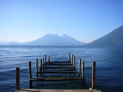
Lake Atitlán (Lago de Atitlán), located in the highlands of Guatemala, is one of Central America’s most breathtaking natural wonders, often described as one of the world’s most beautiful lakes. Nestled in a volcanic caldera at an elevation of 1,563 meters (5,125 feet), it is surrounded by three towering volcanoes—San Pedro, Tolimán, and Atitlán—and dotted with vibrant indigenous villages. The lake is a cornerstone of Guatemala’s cultural, ecological, and tourism landscape, revered by the Maya people and celebrated by travelers for its stunning scenery and rich cultural tapestry.
Lake Atitlán is located in the Sololá Department,
approximately 145 kilometers (90 miles) west of Guatemala City and 50
kilometers (31 miles) from Antigua. The lake sits within a massive
caldera formed by a supervolcanic eruption approximately 84,000 years
ago, which left a basin that filled with water over millennia. The lake
measures about 18 kilometers (11 miles) long and 8 kilometers (5 miles)
wide at its widest point, covering an area of roughly 130 square
kilometers (50 square miles). Its maximum depth is estimated at 340
meters (1,115 feet), making it one of the deepest lakes in Central
America.
The lake is framed by three prominent volcanoes:
Volcán San Pedro (3,020 meters/9,908 feet): A popular hiking destination
on the western shore, known for its challenging trails and panoramic
views.
Volcán Tolimán (3,158 meters/10,361 feet): A twin-peaked
volcano on the southern shore, less frequently climbed but visually
striking.
Volcán Atitlán (3,537 meters/11,604 feet): The highest of
the trio, also on the southern shore, with a rugged, forested profile.
The surrounding landscape includes steep, forested hills, terraced
agricultural fields, and coffee plantations, creating a dramatic
backdrop. The lake’s water is famously clear, with hues ranging from
deep blue to turquoise, depending on sunlight and weather. However,
water quality has been a concern in recent decades due to pollution and
algae blooms, though conservation efforts are ongoing.
The
region’s climate is temperate, with average temperatures of 20–25°C
(68–77°F) year-round. The dry season (November–April) offers clear skies
and ideal conditions for outdoor activities, while the rainy season
(May–October) brings lush greenery but occasional heavy showers,
particularly in the afternoons.
Lake Atitlán has been a sacred site for the Maya for
centuries, particularly for the Kaqchikel, Tz’utujil, and K’iche’
peoples, who make up the majority of the region’s population. In Maya
cosmology, the lake is considered a spiritual center, associated with
creation myths and revered as a source of life. The volcanoes are
believed to be guardians or deities, and the lake’s waters are used in
rituals and ceremonies.
The area has been inhabited since
pre-Columbian times, with archaeological evidence suggesting Maya
settlements dating back to at least 300 BCE. The lake’s villages were
established as permanent communities during the Postclassic period
(900–1500 CE), and many retain their indigenous names and traditions.
During the Spanish conquest in the 16th century, the region resisted
colonization longer than other parts of Guatemala, but the Spanish
eventually established missions, leaving a legacy of Catholic churches
alongside Maya spirituality.
In the 20th century, Lake Atitlán
gained international attention through the writings of Aldous Huxley,
who in his 1934 book Beyond the Mexique Bay described it as “too much of
a good thing,” comparing its beauty to Lake Como with the added drama of
volcanoes. The lake became a magnet for hippies and travelers in the
1960s and 1970s, particularly in Panajachel, and has since grown into a
major tourism destination while retaining its indigenous character.
Culturally, the lake is a vibrant mosaic of Maya traditions, with
each village known for distinct customs, dialects, and crafts. The
region faced challenges during Guatemala’s civil war (1960–1996), with
some villages experiencing violence, but today, it is a peaceful area
focused on tourism, agriculture, and cultural preservation.
Environmental issues, such as pollution from sewage and agricultural
runoff, have prompted local and international efforts to protect the
lake, including clean-up initiatives and sustainable tourism practices.
Lake Atitlán’s natural beauty is defined by its
dramatic setting and ecological diversity, making it a haven for nature
lovers and photographers.
The Lake
The lake’s crystal-clear
waters are its centerpiece, reflecting the volcanoes and sky in a
kaleidoscope of blues and greens. The water’s clarity is due to its
volcanic origin and minimal industrial pollution, though cyanobacteria
blooms (caused by nutrient runoff) have occasionally clouded the surface
in recent years. The lake supports a variety of fish, including
introduced species like bass, as well as crabs and aquatic plants. Its
depth creates a serene, almost mystical quality, with calm mornings
offering mirror-like reflections of the surrounding landscape.
Volcanoes and Mountains
The three volcanoes dominate the skyline,
their conical shapes creating a postcard-perfect backdrop. The
surrounding hills are covered in subtropical forests, with patches of
pine, oak, and coffee plantations. The steep terrain limits development,
preserving the area’s natural beauty but making access to some villages
challenging.
Biodiversity
The Lake Atitlán region is a
biodiversity hotspot, with ecosystems ranging from aquatic to montane.
Wildlife includes:
Birds: Over 300 species, such as herons,
kingfishers, and the endemic Atitlán grebe (now extinct due to
introduced fish). Birdwatching is popular, especially in nature reserves
like San Buenaventura.
Mammals: Small mammals like opossums, coatis,
and bats are common, with occasional sightings of monkeys in higher
forests.
Flora: Orchids, bromeliads, and ferns thrive in the humid
climate, alongside coffee, avocado, and corn fields cultivated by local
farmers.
The lake’s microclimates, influenced by altitude and
volcanic soil, support diverse agriculture, with coffee being a major
export. However, deforestation and erosion are ongoing challenges,
addressed through reforestation and sustainable farming initiatives.
Sunrises and Sunsets
The lake is renowned for its spectacular
sunrises and sunsets, when the sky ignites with pinks, oranges, and
purples, casting reflections on the water. Viewing spots like the
Mirador de San Jorge or boat tours at dawn are popular for capturing
these moments.
The lake is encircled by 12 main villages, each with
its own character, traditions, and attractions. Most are predominantly
Maya, with residents speaking Kaqchikel or Tz’utujil alongside Spanish.
Below are the key villages, accessible by boat (lancha) or road:
Panajachel (“Pana”):
Description: The largest and most developed
village, serving as the gateway to the lake. It has a vibrant tourist
scene with hotels, restaurants, and markets.
Highlights: Calle
Santander (a bustling street with shops and cafés), the public market
for textiles and crafts, and boat docks for lake tours.
Vibe:
Cosmopolitan, with a mix of backpackers, expats, and locals.
San
Pedro La Laguna:
Description: A bohemian hub popular with younger
travelers, known for affordable hostels, yoga retreats, and nightlife.
Highlights: Hiking Volcán San Pedro, Spanish schools, and the San Pedro
Church. The village is famous for its coffee and street art.
Vibe:
Laid-back, with a hippie and adventure-seeking atmosphere.
San
Juan La Laguna:
Description: A quieter, culturally rich village
focused on sustainable tourism and artisanal crafts.
Highlights:
Women’s weaving cooperatives (e.g., Asociación de Mujeres Tejedoras),
natural dye workshops, and murals depicting Tz’utujil culture. The
Mirador de San Juan offers stunning lake views.
Vibe: Artistic and
community-driven, ideal for cultural immersion.
Santa Cruz La
Laguna:
Description: A serene village built into steep hills,
accessible mainly by boat, with a focus on eco-tourism.
Highlights:
The Calle de la Playa for swimming, kayaking, and diving (the lake’s
only dive school is here). The Cerro de la Cruz trail offers panoramic
views.
Vibe: Tranquil and nature-focused, perfect for relaxation.
Jaibalito:
Description: A small, secluded village with limited
infrastructure, known for its peaceful setting.
Highlights:
Eco-lodges like Posada Jaibalito, hiking trails, and a community-driven
atmosphere.
Vibe: Remote and rustic, ideal for off-the-grid escapes.
Tzununá:
Description: Another quiet village with boutique hotels
and yoga retreats, less visited by tourists.
Highlights: Scenic
walks, coffee farm tours, and the Lush Atitlán eco-resort.
Vibe:
Intimate and serene, with a focus on wellness.
San Marcos La
Laguna:
Description: The “spiritual” village, famous for yoga,
meditation, and holistic centers.
Highlights: The Cerro Tzankujil
nature reserve with a cliff-jumping platform, yoga schools like Eagle’s
Nest, and vegetarian cafés.
Vibe: New Age and introspective,
attracting wellness seekers.
Santiago Atitlán:
Description:
The largest Tz’utujil village, known for its vibrant market and cultural
heritage.
Highlights: The Church of Santiago Apóstol, home to Maximon
(a syncretic Maya-Catholic deity), the Parque de la Paz (a memorial to
civil war victims), and textile markets.
Vibe: Traditional and
bustling, with deep cultural roots.
Other villages, such as San
Antonio Palopó, San Lucas Tolimán, Santa Catarina Palopó, and San Andrés
Semetabaj, are smaller but offer unique experiences, such as pottery in
San Antonio or colorful murals in Santa Catarina.
Lake Atitlán offers a wide range of activities,
blending adventure, culture, and relaxation. Most visitors spend 3–7
days exploring multiple villages, using Panajachel or San Pedro as a
base. Key activities include:
Boating and Kayaking: Public boats
(lanchas) connect villages for 10–25 GTQ ($1.30–$3.25 USD) per trip,
offering scenic rides across the lake. Private boat tours at sunrise or
sunset provide photography opportunities. Kayaking and paddleboarding
are popular in Santa Cruz and San Pedro, with rentals at $5–$10
USD/hour.
Hiking: Trails range from easy walks to challenging
ascents:
Volcán San Pedro: A 4–6-hour round-trip hike with 360-degree
views (guided tours ~$20 USD).
Indian Nose (Rostro Maya): A 2–3-hour
sunrise hike from San Juan or Santa Clara, offering stunning lake vistas
(~$15 USD with guide).
Cerro Tzankujil: A short hike in San Marcos
with a cliff-jumping platform.
Cultural Tours: Visit weaving
cooperatives, coffee farms, or Maximon shrines in Santiago Atitlán.
Cooking classes and Maya spirituality workshops are available in San
Juan and San Marcos.
Yoga and Wellness: San Marcos and Tzununá offer
daily yoga classes, meditation retreats, and massage therapies, often in
open-air studios with lake views ($5–$15 USD/class).
Shopping:
Markets in Panajachel, Santiago, and San Juan sell handwoven textiles,
beaded jewelry, and wooden crafts. Bargaining is common, but respect
fair prices to support artisans.
Swimming and Diving: The lake’s
calmer bays, like those in Santa Cruz or San Pedro, are ideal for
swimming. Scuba diving in Santa Cruz explores underwater volcanic
formations and sunken structures (~$50 USD/dive).
Nightlife and
Dining: San Pedro has lively bars with live music, while Panajachel
offers restaurants serving Guatemalan (e.g., pepián) and international
cuisine. San Marcos specializes in vegetarian and vegan options.
The
visitor experience varies by village, from the bustling energy of
Panajachel to the spiritual calm of San Marcos. The lake’s beauty is
ever-present, but visitors should be prepared for basic infrastructure
in smaller villages, occasional power outages, and variable weather.
Lake Atitlán is a culturally sensitive and
ecologically fragile area. Visitors are encouraged to:
Respect
Maya Traditions: Ask permission before photographing people or
ceremonies, especially in Santiago Atitlán. Dress modestly when visiting
churches or shrines.
Support Local Economies: Buy crafts from
cooperatives, eat at family-run comedores, and hire local guides.
Minimize Environmental Impact: Avoid using sunscreen or soaps when
swimming, use reusable water bottles, and support eco-friendly
businesses. The lake’s pollution issues require collective
responsibility.
Learn Basic Phrases: Knowing a few words in Spanish
or Kaqchikel/Tz’utujil (e.g., “b’antiox” for thank you) fosters
goodwill.
Location: Sololá Department, Guatemala, 145 km west of
Guatemala City.
Getting There:
From Guatemala City: 3–4-hour
shuttle or bus to Panajachel ($10–$20 USD). Chicken buses are cheaper
(~$5 USD) but less comfortable.
From Antigua: 2–3-hour shuttle
($10–$15 USD) or public bus via Chimaltenango.
From Quetzaltenango
(Xela): 2.5–3-hour shuttle ($15–$20 USD).
Boats connect villages from
Panajachel or San Pedro (10–25 GTQ/trip).
Accommodation:
Panajachel: Hotels like Posada Don Rodrigo ($50–$100 USD) or hostels
($10–$20 USD).
San Pedro: Budget options like Hostel Fe ($5–$15 USD)
or mid-range hotels ($30–$60 USD).
San Marcos: Eco-lodges like
Circles Hostel ($15–$40 USD).
Santiago: Basic guesthouses ($20–$50
USD).
Entrance: No fee to access the lake, but some activities (e.g.,
nature reserves, hikes) have small fees (10–50 GTQ).
Hours: Villages
are open 24/7, but markets and attractions typically operate 8:00
AM–6:00 PM.
Best Time to Visit:
Dry Season (November–April):
Clear skies, ideal for hiking and boating.
Rainy Season
(May–October): Greener scenery, fewer crowds, but muddy trails and
afternoon showers.
What to Bring:
Lightweight clothing, a rain
jacket (rainy season), and sturdy shoes for hiking.
Sunscreen, insect
repellent, and a reusable water bottle.
Cash (GTQ) for boats,
markets, and small vendors, as ATMs are limited outside Panajachel.
Tips:
Book shuttles and tours in advance during peak season.
Use reputable boat operators and confirm prices before boarding.
Be
prepared for steep paths and limited Wi-Fi in smaller villages.
Check
lake conditions, as strong winds (locally called xocomil) can disrupt
boat travel in the afternoons.
Huxley’s Praise: Aldous Huxley’s glowing description
in 1934 helped put Lake Atitlán on the global map, cementing its
reputation as a must-see destination.
Xocomil Winds: The lake’s
afternoon winds, caused by temperature differences between the lake and
highlands, are named xocomil (meaning “to pick up sin” in Kaqchikel),
linked to a legend about cleansing wrongdoings.
Maximon Worship:
Santiago Atitlán’s veneration of Maximon, a syncretic deity blending
Maya and Catholic elements, is a unique cultural practice, with rituals
involving offerings of alcohol and cigars.
Volcanic Origins: The
lake’s caldera was formed by a massive eruption, and ongoing tectonic
activity makes the region seismically active, though major quakes are
rare.
Textile Art: The lake’s villages are renowned for handwoven
textiles, with each community using distinct patterns and colors (e.g.,
blue for Santa Catarina, red for Santiago).