Location: Chiriquí Province Map
Elevation: 3,474 metres (11,398 ft)
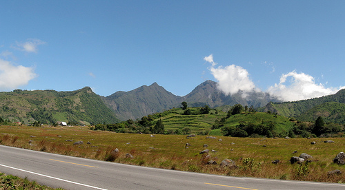
Volcán Barú, also known as Volcán de Chiriquí, is an active stratovolcano and the highest peak in Panama, standing at 3,475 meters (11,401 feet) above sea level. Located in the Chiriquí Province near the border with Costa Rica, approximately 35 km east of the Talamanca Range, it is a geological and ecological marvel within the Volcán Barú National Park, a protected area spanning 14,325 hectares (35,400 acres). Renowned for its unique position allowing rare views of both the Pacific Ocean and Caribbean Sea from its summit on clear days, Volcán Barú is a magnet for hikers, birdwatchers, and nature enthusiasts. Its rich biodiversity, volcanic history, and cultural significance make it a cornerstone of Panama’s natural heritage.
Volcán Barú is situated in the Cordillera de Talamanca, south of
Panama’s continental divide, approximately 50 km from the
Pacific Ocean and 40 km from the Atlantic (Caribbean Sea). Its
strategic location in the narrow isthmus of Panama, combined
with its height, makes it one of the few places in the world
where both oceans can be seen simultaneously on a clear day, a
phenomenon best observed early in the morning during the dry
season (December–April). The volcano is shared by three
districts—Boquerón, Boquete, and Tierras Altas—with the towns of
Boquete (eastern flank), Volcán, and Cerro Punta (western side)
serving as primary access points. The city of David, 40 km from
Boquete, is the nearest major urban center, accessible by a
6-hour drive or 1-hour flight from Panama City.
Geologically, Volcán Barú is a complex, predominantly andesitic
stratovolcano with a 6-km-wide summit caldera breached to the
west due to a massive landslide approximately 9,000 years ago.
This landslide created a debris-avalanche deposit that extended
to the Pacific coastal plain, covering 20–30 km³, the largest
documented in Central America and nearly ten times the volume of
the 1980 Mount St. Helens avalanche. Post-collapse eruptions
have formed lava domes within the caldera, some exceeding the
caldera rim’s height, with the youngest dome complex visible
today. The volcano features seven craters, adding to its rugged
topography of lava formations, tuffs, and volcanic cliffs.
Volcán Barú’s activity is driven by subduction along the
Central American Volcanic Arc, with lavas derived from
calc-alkaline processes and younger adakites (partial melts from
the subducted slab). Radiometric dating indicates volcanism from
20 million years ago to recent times, with significant eruptions
at 9280 BC, 7420 BC, 1270 BC, 260 AD, 710 AD, 1130 AD, 1340 AD,
and a documented explosive eruption around 1550 AD. The most
notable prehistoric eruption around 700 AD destroyed settlements
near Cerro Punta, while the 16th-century eruption spread tephra
and pyroclastic flows. Seismic swarms in 1930, 1965, 1985, and
2006 suggest ongoing tectonic activity, with researchers like
Arkin Tapias noting “small, imperceptible earthquakes”
indicating the volcano is “snoring” but not imminently
dangerous.
The volcano’s slopes support fertile highlands
drained by the Chiriquí Viejo, Caldera, Piedra, and Macho de
Monte Rivers. The town of Volcán sits on a lahar deposit from a
caldera breach, where a river has exposed an ancient forest
dated to 1000 years ago. The volcano’s past height is estimated
at over 4,600 meters, with perpetual snow on its summit, but a
lateral eruption reduced it to its current elevation, leaving a
horseshoe-shaped summit.
Volcán Barú National Park, established in 1976, is part of the
Mesoamerican Biological Corridor, protecting a mosaic of
ecosystems ranging from 1,400 to 3,475 meters in elevation. The
park’s diverse climates and altitudes foster six distinct forest
types: Very Humid Montane Forests, Low Humid Montane Forests,
Low Montane Rainforests, Montane Rainforests, Very Humid Low
Montane Forests, and Premontane Rainforests. These habitats
support a rich biodiversity, including endemic plants, vibrant
wildflowers, and areas of lava flow with sparse vegetation,
creating unique ecological niches.
Flora
The park’s
lower slopes are dominated by large trees, transitioning to
smaller plants, shrubs, scrub, and alpine wildflowers at higher
elevations. Notable flora includes orchids, ferns, mosses, and
giant tree species in the humid tropical forests. Cloud-shrouded
forests, such as the Lower Montane Evergreen Broadleaf Forest,
host epiphytes and bromeliads, while areas like El Paso del
Respingo are known for their lush vegetation, ideal for
photography.
Fauna
The park is a biodiversity hotspot,
home to:
Birds: Over 250 species, including the Resplendent
Quetzal (most visible February–May), Black Guan, Black-and-White
Hawk-Eagle, Volcano Junco, Wrenthrush, Yellow-Thighed
Brushfinch, Timberline Wren, Sooty Thrush, and the rare
Unspotted Saw-Whet Owl (recorded at 2,280 m). The park hosts 48
of 54 species of the Costa Rica-Panama Highlands Endemic Bird
Area (EBA) and is the only known Panama site for Timberline
Wren, Sooty Thrush, and Volcano Junco. Birdwatching spots like
Los Quetzales Trail and El Paso del Respingo are renowned for
spotting quetzals and toucans.
Mammals: All five of Panama’s
big cats (puma, jaguar, ocelot, margay, jaguarundi) inhabit the
park, with the puma (Puma concolor) being the most abundant.
Other mammals include Underwood’s water mouse, tlacuaches
(opossums), armadillos, gray foxes, weasels, skunks, badgers,
squirrels, rabbits, and hares. Historical records note black
bears and peccaries, though their populations have declined.
Reptiles and Amphibians: Various snakes, lizards, and frogs
thrive in the humid forests, though less documented.
The
park’s biodiversity supports ecotourism and scientific research,
but its ecosystems are vulnerable to agricultural encroachment
and climate change. Conservation efforts focus on maintaining
trails like Los Quetzales and protecting habitats for species
like the quetzal.
Volcán Barú holds cultural significance for the Ngöbe indigenous
people and Latino communities living in the park’s vicinity. The
fertile highlands, with temperatures as low as 14°C, support
Panama’s most productive agriculture, particularly around
Boquete and Cerro Punta, often called Panama’s “vegetable
garden”. Coffee plantations, strawberry fields, and vegetable
farms thrive, with Boquete renowned for its aromatic coffee,
featured in local tours.
The volcano’s geological history
ties to the formation of the Isthmus of Panama 500,000 years ago
through effusive volcanic activity. Its eruptions have shaped
local history, notably the 700 AD eruption that ended occupation
at the Cerro Punta archaeological site, and the 1550 AD
eruption, documented by Spanish navigators. The Smithsonian
Tropical Research Institute traces activity back to 9280 BC,
with five eruptions in the last 1,800 years, occurring roughly
every 400–500 years.
Culturally, Volcán Barú is a symbol
of Panama’s natural heritage, often called the “roof of Panama”.
Its summit, adorned with a cross and communication towers, is a
point of pride, as reflected in social media posts celebrating
its status as the nation’s highest peak. The volcano’s potential
activity, described as “snoring” by researchers, adds a layer of
mystique, with locals and scientists monitoring its seismic
“snores” for signs of awakening.
Volcán Barú is a premier destination for adventure and
eco-tourism, offering challenging hikes, birdwatching, and
breathtaking views. The Volcán Barú National Park is open from
8:00 AM to 6:00 PM, though night hikes for sunrise are popular
despite occasional trail closures (e.g., pre-5 AM restrictions
noted in 2022).
Access and Transportation
Location:
Chiriquí Province, near Boquete (eastern access), Volcán, and
Cerro Punta (western access). From Panama City, reach David via
a 1-hour flight (~$100 USD) or 6-hour bus (~$15 USD) from
Albrook Station, then a 25-minute bus/taxi to Boquete (~$2–10
USD).
By Car: Renting a car (~$30–50 USD/day) offers
flexibility. From David, drive 40 km to Boquete. Rural roads are
rough, with potholes and gravel, requiring caution.
By
Shuttle: Hello Travel Panama shuttles from destinations like
Santa Catalina or Costa Rica cost ~$50 USD.
Trail Access:
Two main routes:
Boquete Route: A 13.5-km (8.5-mile) trail, a
steep, rocky fire road to the summit, accessed via a gravel road
to communication towers. Often used for night hikes or 4x4
tours.
Volcán Route (Paso Ancho): A more scenic, challenging
trail through diverse flora and fauna, leading to the crater for
camping. Preferred for its panoramic views.
Entrance and
Facilities
Cost: Officially free, as the park is not actively
maintained, though a $5 USD sign may be posted at the Boquete
entrance. Night hikers often bypass this, as no guards are
present. Guided tours (~$50–100 USD) or 4x4 trips (~$150–200
USD) cover costs.
Facilities:
Boquete: Basic tourist
information center, no formal park amenities. Hotels provide
trail directions.
Summit: Communication towers, a cross, and
minimal shelter. No restrooms or water sources.
Trails:
Poorly maintained, rocky, and rutted, with no amenities. Bring
all supplies.
Rules:
No littering to protect
ecosystems.
Avoid disturbing wildlife, especially birds.
Night hikers need headlamps and permits if enforced.
Hiking to the Summit:
Boquete Trail: A grueling 13.5-km
one-way hike (27 km round-trip), taking 4–6 hours up and 3–4
hours down. The trail is a steep, rocky fire road, described as
an “ankle buster”. Night hikes (starting 1–2 AM) aim for sunrise
views but face near-freezing temperatures (-2°C to 3°C) and
brutal winds. Layers, sturdy boots, and 2.5 liters of water per
person are essential. Views of both oceans are rare, obscured by
clouds after 10 AM.
Volcán Route (Paso Ancho): An 8-hour
round-trip trail, more scenic with forest and crater views.
Camping at the crater is recommended for its unique ecosystem.
Guides (+507 66767314) enhance safety and navigation.
Difficulty: Strenuous, requiring physical and mental
preparation. The incline, rocky terrain, and altitude challenge
even fit hikers. Knee issues or poor fitness may hinder
completion.
Guides: Highly recommended (~$20–50 USD),
especially for night hikes or the Volcán route, to navigate and
avoid risks like getting lost or hypothermia.
4x4 Tours: A
1.5-hour rugged ride to the summit (~$150–200 USD) via Volcano
Baru 4x4 company is ideal for non-hikers. Roads are treacherous,
with boulders and washouts, but offer sunrise views without the
trek.
Camping: Permitted near the summit or crater (Volcán
route), requiring tents, sleeping bags, and cold-weather gear.
The crater offers a more sheltered, scenic campsite.
Birdwatching: Los Quetzales Trail (Cerro Punta to Boquete) and
El Paso del Respingo are prime spots for quetzals, toucans, and
endemic species. Guided tours (~$30–50 USD) maximize sightings.
Other Activities: Rafting or canoeing on the Chiriquí Viejo
River, rock climbing, mountain biking, and coffee tours in
Boquete complement the volcanic experience.
Visitor
Experience
Summit Views: On clear days, the summit offers
panoramic vistas of both oceans, the Cordillera Central, and
cities like David. A cross and antenna array mark the peak, with
clouds often rolling in by midday. Sunrise hikes are popular,
with “killer views” described as a “top life experience”.
Challenges: The trail’s relentless incline, cold summit
temperatures, and lack of amenities demand preparation. Night
hikes in darkness require headlamps and mental fortitude. Clouds
often obscure ocean views, disappointing some hikers.
Cultural Immersion: Boquete’s coffee culture and Ngöbe
interactions enrich visits. Stops at places like Finca El Oasis
for breakfast post-hike add local flavor.
Accommodations
Boquete: Budget hostels (~$10–20 USD/night, e.g., Hostel
Mamallena), mid-range hotels (~$50–100 USD, e.g., Hotel Isla
Verde), or luxury lodges (~$150–300 USD, e.g., Boquete Tree
Trek).
Volcán: Smaller guesthouses (~$30–70 USD, e.g., Gamma
Monterrey Rincón de Santiago).
Cerro Punta: Basic lodges
(~$20–50 USD).
Dining
Boquete: Cafés like Café Ruiz
serve local coffee and Panamanian dishes (e.g., sancocho, ~$5–15
USD). Finca El Oasis offers post-hike meals.
Volcán: Simple
eateries with regional fare (e.g., tamales, ~$3–10 USD).
Park: No food vendors; bring snacks and meals.
Weather: The dry season (December–April) is best for clear
summit views, though mornings are critical to beat clouds. The
wet season (May–November) brings rain, mud, and mist,
complicating hikes. Summit temperatures drop to -2°C in
December–March, with occasional granular snow or frost.
Trail
Conditions: The Boquete trail is a rocky, unmaintained fire
road, risky for ankles and knees. The Volcán route is scenic but
challenging, requiring guides for safety.
Physical Demands:
The hike’s 2,000–2,400-meter elevation gain and 27-km round-trip
distance are grueling. Posts on X emphasize training (e.g.,
walking 10 km on flat terrain before attempting). Not suitable
for those with knee issues or poor fitness.
Safety: No guards
or amenities increase risks. Night hikes face cold, wind, and
potential disorientation. Guides mitigate these, and 4x4 tours
are safer for non-hikers.
Volcanic Hazards: Though dormant,
the volcano’s history of pyroclastic flows, lahars, and tephra
fallout poses risks. A 2007 USGS study warns that future
eruptions could disrupt Boquete, Volcán, and Bambito, with
lahars reaching the Pan-American Highway. Over 10,000 people
live in high-risk zones.
Park Maintenance: The park’s lack of
an “operational” managing entity results in poor trail upkeep
and unclear entrance fees, as noted by hikers.
Volcán Barú is Panama’s crown jewel, offering a challenging yet
rewarding adventure. The chance to stand at the nation’s highest
point, potentially seeing both the Pacific and Caribbean, is a
rare draw, described as “truly breathtaking” by visitors. Its
lush cloud forests, home to quetzals and big cats, captivate
birdwatchers and wildlife enthusiasts, while the fertile
highlands showcase Panama’s agricultural heart. The volcano’s
active status, with a history of explosive eruptions, adds
intrigue, tempered by assurances of predictable seismic
warnings.
For hikers, the summit trek is a test of
endurance, with “killer views” and a sense of accomplishment.
For non-hikers, 4x4 tours or gentler trails like Bajo Mono Loop
provide access to the park’s beauty. Boquete’s coffee culture
and Ngöbe heritage enrich the experience, making Volcán Barú a
holistic destination. As posts on X highlight, it’s a source of
national pride, urging protection of its unique ecosystems.
Whether for adventure, ecology, or culture, Volcán Barú is, as
one official called it, “one of the wonders of Panama”.
Practical Tips:
Timing: Start night hikes at 1–2 AM for
sunrise (5:30–6 AM). Day hikes begin at 5 AM to beat clouds.
Gear: Pack 2.5 liters of water, snacks, headlamp, layers
(fleece, windbreaker), sturdy boots, and a poncho for rain. Swim
shoes are unnecessary, unlike cenote visits.
Guides: Book via
Boquete hotels or contacts like +507 66767314 for the Volcán
route.
Transport: Arrange return taxis (~$5 USD/person) from
Boquete, as parking is limited.
Conservation: Avoid
disturbing wildlife or formations; support local guides to fund
preservation.
Combine: Pair with Boquete coffee tours, Los
Quetzales Trail, or Presa de la Boca for a multi-day itinerary.
Kris Kremers and Lisanne Froon were close friends and roommates
who had saved for six months to fund a six-week trip to Panama,
combining adventure, cultural immersion, and volunteer work.
Kris, described as open, creative, and responsible, had
completed a degree in cultural social education with a focus on
art at the University of Utrecht. Lisanne, characterized as
optimistic, intelligent, and a passionate volleyball player, had
graduated with a degree in applied psychology from Deventer. The
trip was a graduation present for Lisanne and an opportunity to
learn Spanish and volunteer with children.
The women
arrived in Panama on March 15, 2014, spending two weeks
exploring tourist spots before moving to Boquete on March 29 to
live with a host family and volunteer at a local school.
However, they were disappointed to learn there was no place for
them at the school, prompting them to fill their time with other
activities, including hiking.
On April 1, 2014, around 11:00 AM, Kris and Lisanne set out to
hike the El Pianista Trail, a 4–6 km (2.5–3.7 miles) path near
Volcán Barú, known for its scenic views of the Continental
Divide. The trail, rated moderate, typically takes 4–5 hours
round-trip and winds through cloud forests and rugged terrain.
They were accompanied by Azul, the host family’s dog, according
to some sources, and posted on Facebook about their plan to
explore Boquete. They were reportedly seen having brunch with
two Dutch men before starting the hike.
The women carried
minimal supplies, including Lisanne’s Canon PowerShot SX270 HS
camera, their phones (Kris’s iPhone 4 and Lisanne’s Samsung
Galaxy S III), and a small amount of cash. They wore light
clothing (t-shirts, shorts) unsuitable for the jungle’s
unpredictable weather, which can shift from hot (20–30°C) to
cold and rainy, especially at higher elevations.
That
evening, Azul returned to the host family’s home without Kris
and Lisanne, raising initial concern. The women missed a
scheduled tour with a local guide on April 2, prompting the host
family to alert authorities. Lisanne’s parents, who had been
receiving daily texts, grew worried when communication ceased,
an unusual break from their routine.
On April 3, locals organized aerial and ground searches along
the El Pianista Trail, but no trace of the women was found. By
April 6, their parents arrived in Panama with Dutch police,
detectives, and tracker dogs trained to detect scents up to nine
days old. Despite a 10-day intensive search involving
helicopters, dog units, and volunteers, no leads emerged. A
$30,000 reward was offered for information, to no avail.
The National System of Civil Protection (NSCP) faced criticism
for initially dismissing the report, delaying serious action for
four days. A Dutch investigator publicly stated that the women
“could not have simply disappeared from the trail,” introducing
the possibility of foul play.
On June 14, 2014, ten weeks after the disappearance, a Ngäbe
woman from Alto Romero, a village in Bocas del Toro Province,
found Lisanne’s blue backpack near a riverbank along the Culebra
River, 15 km from the El Pianista Trail. She claimed the
backpack was not there the previous day, raising suspicions. The
backpack, retrieved by helicopter, was in good condition despite
weeks in a rainy jungle, containing:
$83 USD in cash
Two pairs of sunglasses
Lisanne’s insurance card
A water
bottle
Two bras
Lisanne’s camera
Both women’s phones
34 fingerprints (13 on the bag) and unidentified DNA, none
leading to suspects
Notably, Lisanne’s asthma inhaler was
missing, and the contents were dry, unusual given the heavy
rainfall in the area.
Phone Logs
The phones provided
critical but puzzling data:
April 1, 4:39 PM: Kris’s iPhone
attempted to call 112 (international emergency number used in
Panama).
April 1, 4:51 PM: Lisanne’s Samsung Galaxy S III
attempted 112. Neither call connected due to no signal.
April
2–3: Multiple unsuccessful attempts to call 112 and 911 from
both phones at various times (e.g., 6:14 AM, 6:58 AM, 10:53 AM,
9:33 AM, 1:50 PM).
April 4, 5:56 AM: Lisanne’s phone battery
died after being turned on to check for a signal.
April 5–11:
Kris’s iPhone was turned on intermittently (e.g., 9:33 AM, 4:42
PM) to search for reception, but the correct PIN was never
entered, suggesting either no PIN attempts or incorrect entries.
The final activation was on April 11 at 10:51 AM, turned off at
11:56 AM.
The phones showed 77 attempted emergency calls over
several days, none connecting due to the remote location’s lack
of cell service.
Camera Evidence
Lisanne’s camera
contained 100 photos, offering cryptic clues:
April 1,
Daytime: Ten photos showed the women on the El Pianista Trail,
reaching the Mirador (summit) around 1:00 PM, then continuing
north past the Continental Divide onto an unofficial trail.
Photos depicted Kris crossing a stream and both women in
seemingly good spirits, with no signs of distress. The last
daytime photo, Image 508, showed Kris near a stream, hours
before the first emergency call.
April 8, 1:00–4:00 AM:
Ninety flash photos were taken in near-complete darkness, likely
in a jungle or ravine. Most were blurry, showing:
A twig with
plastic bags on a rock
A backpack strap and mirror on another
rock
Toilet paper and trash
The back of Kris’s head,
possibly lying face-down, with some speculating a pool of blood
(visible on bedrock)
Lisanne’s cheek and hand reflecting the
flash
Skyward shots with water droplets, possibly from rain
or a waterfall
Missing Photo: Image 509 was deleted and
unrecoverable, taken between the last daytime photo (April 1)
and the first nighttime photo (April 8). Its deletion is a point
of contention.
The nighttime photos suggest panic, possibly
an attempt to signal for help using the flash or document their
surroundings. The absence of clear landmarks complicates
interpretation.
In June–August 2014, searches along the Culebra River, prompted
by the backpack’s discovery, yielded:
Kris’s denim
shorts, found atop a rock on the opposite bank, a few kilometers
from the backpack.
A pelvic bone and a boot with a foot
inside, later identified as Lisanne’s via DNA.
33 bone
fragments scattered along the riverbank, confirmed as belonging
to both women.
Lisanne’s remains: A femur and tibia with
intact bone marrow, dry and undecomposed, and a piece of skin
with maggots, indicating early decomposition. No marks or
scratches were found.
Kris’s remains: A pelvis (broken,
unclear if pre- or post-mortem) and other bones, stark white and
appearing “bleached” with high phosphorus levels not matching
local soil. No cuts or animal predation marks were noted.
A
Panamanian forensic anthropologist reported no discernible marks
under magnification, ruling out natural or cultural damage. The
contrasting conditions—Lisanne’s remains with flesh versus
Kris’s bleached bones—raised questions about environmental
factors or manipulation.
The Panamanian investigation, initially classified as a homicide
then abduction, concluded in March 2015 that the deaths were a
hiking accident. Dutch forensic teams largely agreed, citing the
rugged terrain, 30–40-meter cliffs, and swift river currents as
likely causes. The official theory posits:
The women
ventured beyond the Mirador onto an unofficial trail, becoming
lost.
They attempted to follow a river, a common survival
tactic, but this led them deeper into the wilderness north of
the divide, away from Boquete’s developed south.
Heavy rain,
common in April (the start of the wet season), caused flash
floods or slips, possibly leading to a fall from a monkey bridge
(a precarious cable crossing) or cliff.
Their remains were
washed downstream, explaining their scattered distribution.
Dutch private investigators, hired by the families, and SOME
Panamanian police suspected foul play, citing:
The
backpack’s pristine condition and the woman’s claim it appeared
suddenly.
The bleached state of Kris’s bones and high
phosphorus levels, suggesting possible chemical manipulation.
The deleted photo (Image 509) and fingerprints/DNA on the
backpack.
The nighttime photos, interpreted by some as
evidence of distress or third-party involvement.
The families
accepted the accident theory, finding closure in a natural death
scenario. A memorial was erected at the Mirador, warning hikers
not to proceed further.
The case’s ambiguities have fueled numerous theories, debated by
investigators, journalists, and online communities:
Accidental Death:
The women got lost, fell into a ravine or
river, or were caught in a flash flood. The nighttime photos may
reflect Lisanne’s attempt to signal or document Kris’s
injury/death.
Supporting evidence: Phone logs show prolonged
survival attempts, rugged terrain, and no marks on bones
suggesting violence. Dutch authors Marja West and Jürgen Snoeren
(in Lost in the Jungle) argue Kris died from a fall, and Lisanne
perished later while seeking help.
Weaknesses: The backpack’s
condition, Kris’s bleached bones, and the sudden appearance of
evidence challenge this narrative.
Foul Play:
Theories
range from kidnapping by locals, murder by a tour guide, gang
involvement, or capture by cannibals. Some speculate Kris was
trafficked, though no evidence supports this.
Supporting
evidence: The deleted photo, fingerprints, and bleached bones
suggest tampering. A 2017 investigation linked the case to local
murders, and the deaths of key witnesses raised suspicions.
Posts on X and Reddit note the backpack’s placement as potential
planting.
Weaknesses: No concrete evidence of violence or
suspects. The backpack’s location in a raging river makes
planting risky, as Jürgen Snoeren argued.
Environmental
Factors:
Starvation, hypothermia, or animal encounters (e.g.,
snakes, jaguars) could have contributed. Lisanne’s possible leg
inflammation (noted in autopsy) may have hindered mobility.
Supporting evidence: The jungle’s treacherous terrain, with
cliffs, rivers, and dense vegetation, is deadly for unprepared
hikers. Reddit users with jungle experience describe the
disorienting darkness and sounds.
Weaknesses: The timeline
(surviving until at least April 8) suggests they found water,
and no animal marks were found on bones.
Mixed Scenario:
Some propose an accident followed by third-party interference,
such as locals finding and moving the backpack or remains. The
high phosphorus levels in Kris’s bones might result from
environmental factors or chemical exposure, though tests were
inconclusive.
The Lost in Panama podcast (2022) by Mariana
Atencio and Jeremy Kryt reinvestigated the case, questioning the
accident theory and highlighting investigative flaws, such as
delayed police action and untested DNA/fingerprints. Online
communities, including Reddit’s r/UnsolvedMysteries, debate the
eerie nighttime photos, with some interpreting them as Lisanne’s
desperate attempt to check on Kris or mark their location.
Challenges and Controversies
Investigation Criticism:
Panamanian authorities were criticized for a slow response,
mishandling evidence, and not releasing full autopsies. The
NSCP’s four-day delay and failure to test all fingerprints/DNA
frustrated Dutch investigators.
Evidence Ambiguities: The
backpack’s condition, deleted photo, and bleached bones remain
unexplained. The absence of Lisanne’s inhaler and the phones’
prolonged use without PIN entry puzzle experts.
Cultural
Impact: The case has inspired podcasts, books, and
documentaries, with public fascination driven by the haunting
photos and unresolved questions. The families’ acceptance of the
accident theory contrasts with ongoing speculation.
Environmental Context: The El Pianista Trail’s northern side is
remote, with sparse villages and cattle pastures. Heavy rain and
flash floods in April 2014 could have washed away evidence,
complicating searches.