Location: Healy, Alaska
Area: 6,075,107 acres (24,585 km2)
Denali National Park and Reserve is located in inland Alaska and covers an area around Mount Denali (McKinley until 2015), the highest mountain in North America. The park covers an area of 24,585 km². Christopher McCandless is famous for having lived in it for 4 months, surviving completely alone, before dying. The Alaska mountain range runs through the park and comprises several of Denali's ecosystems. It lodges the Denali mount, the highest of the United States with 6194 meters above sea level, and is therefore one of the Seven Summits. Due to its proximity to the Arctic Circle, its ascent poses extreme difficulties for climbers, despite not being one of the 100 highest peaks in the world. Due to its different altitudes, the park presents several plant zones. Forested areas are rare, with the exception of some southern flat areas near Wonder Lake. In fact, most of the park is composed of tundra. The most frequent trees are spruces and willows, which due to the mineral conditions of the place do not usually develop fully. Cranberries and bison cherries are not rare, and are the basis of the diet of the park's bears. There are also 450 species of flowers, which can be seen mainly in summer, such as the goldenrod, the epilobium, lupine, scilla or gentian.
Individuals entering the
Denali National Park must pay a $10 fee, good for seven days. A
vehicle entrance fee is $20, also good for seven days.
There
are several passes for groups traveling together in a private
vehicle or individuals on foot or on bike. These passes provide free
entry at national parks and national wildlife refuges, and also
cover standard amenity fees at national forests and grasslands, and
at lands managed by the Bureau of Land Management and Bureau of
Reclamation. These passes are valid at all national parks including
Denali National Park:
The $80 Annual Pass (valid for twelve
months from date of issue) can be purchased by anyone. Military
personnel can obtain a free annual pass in person at a federal
recreation site by showing a Common Access Card (CAC) or Military
ID.
U.S. citizens or permanent residents age 62 or over can
obtain a Senior Pass (valid for the life of the holder) in person at
a federal recreation site for $80, or through the mail for $90;
applicants must provide documentation of citizenship and age. This
pass also provides a fifty percent discount on some park amenities.
Seniors can also obtain a $20 annual pass.
U.S. citizens or
permanent residents with permanent disabilities can obtain an Access
Pass (valid for the life of the holder) in person at a federal
recreation site at no charge, or through the mail for $10;
applicants must provide documentation of citizenship and permanent
disability. This pass also provides a fifty percent discount on some
park amenities.
Individuals who have volunteered 250 or more
hours with federal agencies that participate in the Interagency Pass
Program can receive a free Volunteer Pass.
4th graders can
receive an Annual 4th Grade Pass that allows free entry for the
duration of the 4th grade school year (September-August) to the
bearer and any accompanying passengers in a private non-commercial
vehicle. Registration at the Every Kid in a Park website is
required.
In 2018 the National Park Service will offer four days
on which entry is free for all national parks: January 15 (Martin
Luther King Jr. Day), April 21 (1st Day of NPS Week), September 22
(National Public Lands Day), and November 11 (Veterans Day weekend).
Fees can be confusing for Denali National Park. First of all,
there is no park entrance station. As you begin to drive the Park
Road, you are greeted by a gigantic sign that says "Denali National
Park," but you will not be stopped until the staffed gate at mile 15
which is the limit people can drive with their private vehicle. If
you drive up to that gate, you will simply be asked to turn around.
Fees within the first 15 miles of the park, while required, are
done pretty much on the honor system. If you stop in the visitor
center and ask, "Do I need to pay an entrance fee?" The answer is,
"Yes." However, if you had kept driving, nobody will check to see if
you've paid.
"How then," you may ask, "does the park collect
its entrance fees?" Well, if you buy a bus ticket (the only way to
get on the park road past mile 15), or if you stay in a campground,
you will automatically be charged an entrance fee. More than 90% of
the visitors who enter Denali take a bus at one point or another.
The region now known as Denali National Park has been inhabited by Alaska Native peoples for at least 11,000 years, as evidenced by archaeological sites like the Teklanika River digs, which uncovered tools and hearths dating to the end of the last Ice Age. Five distinct Athabaskan language groups—the Ahtna, Dena’ina, Koyukon, Tanana, and Upper Kuskokwim—lived in and around the area, each with deep cultural ties to the land and its towering peak. They called the mountain variations of “the High One” or “the Great One”—Denali in Koyukon, Dinale in Ahtna—reflecting its spiritual significance as a landmark and provider. These nomadic peoples hunted caribou, moose, and Dall sheep, fished rivers like the Nenana, and gathered berries, adapting to the subarctic climate with seasonal camps and sophisticated survival strategies. Their oral traditions, including stories of the mountain’s power, endure today, preserved by descendants and park interpretive programs.
European and American exploration of the Denali region began in the
late 18th century, with Russian traders and trappers venturing inland
from coastal Alaska, though they left little record of the interior. The
first documented sighting of the mountain by a Westerner came in 1794,
when British explorer George Vancouver noted a “stupendous snow
mountain” from Cook Inlet, 150 miles (241 kilometers) away. It wasn’t
until the late 19th century that closer exploration occurred, spurred by
the U.S. purchase of Alaska in 1867 and subsequent gold rushes.
In 1896, prospector William A. Dickey named the peak “Mount McKinley”
after then-presidential candidate William McKinley, a champion of the
gold standard, following a two-month expedition in the area. Dickey’s
account, published in the New York Sun in 1897, cemented the name in
American consciousness, despite local Native names predating it by
millennia. Early climbers and surveyors followed, including Alfred
Brooks of the U.S. Geological Survey, who mapped the region in
1902–1903, and Dr. Frederick Cook, whose fraudulent 1906 summit claim
stirred controversy until Hudson Stuck’s verified ascent in 1913
confirmed the mountain’s true height.
The push to protect the Denali region emerged in the early 20th
century, driven by concerns over wildlife depletion from market hunting
during Alaska’s gold rush era (1896–1910). Charles Sheldon, a wealthy
hunter-conservationist from Vermont, played a pivotal role. Visiting the
area in 1906 and 1907–1908, Sheldon was awestruck by its scenery and
alarmed by the slaughter of Dall sheep and other game to feed miners. He
envisioned a national park to safeguard the ecosystem, lobbying Congress
with support from the Boone and Crockett Club, a conservation group he
co-founded.
Sheldon’s efforts gained traction amid the
Progressive Era’s conservation wave, bolstered by President Theodore
Roosevelt’s legacy of park creation. In 1916, the National Park Service
(NPS) was established, providing a framework for new parks. On February
26, 1917, President Woodrow Wilson signed legislation creating Mount
McKinley National Park, initially spanning 2.2 million acres (890,000
hectares). It was the first Alaskan national park, aimed at protecting
“the splendid herds of caribou, the Dall sheep, and the splendid moose
and grizzly bears,” as Sheldon wrote, though its boundaries excluded
much of the lowland wildlife habitat he sought to include.
The park’s early decades were marked by limited access and slow
development. Managed by the NPS under Superintendent Harry Karstens—a
veteran of the 1913 Denali climb—the park saw its first road
construction in 1923, a 91-mile gravel route from the Alaska Railroad at
McKinley Park Station (now Denali Park) to Kantishna, completed in 1938.
This road, still the park’s only thoroughfare, facilitated ranger
patrols and early tourism, though visitors numbered just a few hundred
annually due to Alaska’s remoteness. The Civilian Conservation Corps
(CCC) built trails and cabins in the 1930s, while World War II briefly
militarized the area with an Army camp near the entrance.
Conservationists, including Sheldon (who died in 1921) and later Adolph
Murie, pushed for expansion to protect broader wildlife ranges. Murie’s
1939–1941 wolf studies in the park, published as The Wolves of Mount
McKinley, highlighted ecological interconnections, influencing park
policy against predator control. By the 1950s, tourism grew with
improved rail and air access, yet the park’s 2 million acres remained a
fraction of the proposed vision. The 1971 Alaska Native Claims
Settlement Act (ANCSA) spurred further action, as Native land selections
threatened adjacent wilderness.
The park’s modern era began with the Alaska National Interest Lands
Conservation Act (ANILCA), signed by President Jimmy Carter on December
2, 1980. This landmark legislation expanded Mount McKinley National Park
to 6 million acres, renaming it Denali National Park and Preserve to
honor Native nomenclature—a move debated since 1975 when Alaska’s
legislature petitioned for the change, resisted by Ohioans defending
McKinley’s legacy until a 2015 federal ruling finalized “Denali.” The
act designated 4 million acres as parkland (strictly protected) and 2
million as preserve (allowing subsistence hunting and trapping),
encompassing the entire Denali massif, lowland taiga, and tundra
ecosystems.
ANILCA tripled the park’s size, protecting caribou
migration routes, grizzly habitats, and the Kantishna goldfields, where
small-scale mining persists under grandfathered claims. It also
established wilderness status for 2 million acres, limiting development
to preserve the park’s pristine character, a decision shaped by
environmentalists like Olaus Murie and Mardy Murie, who saw Alaska as
America’s last frontier.
Since 1980, Denali has evolved into a global destination, hosting
400,000–600,000 visitors annually by the 2010s, drawn by its
wildlife—grizzlies, wolves, moose—and the chance to glimpse Denali’s
peak, visible only 30% of the time due to weather. The park’s shuttle
bus system, introduced in 1972 and expanded post-ANILCA, restricts
private vehicles beyond Mile 15, minimizing impact on the single road’s
92 miles. Facilities remain sparse—Eielson Visitor Center at Mile 66,
campgrounds like Wonder Lake, and the Murie Science and Learning
Center—preserving the wilderness ethos.
Climate change has
emerged as a pressing challenge, with permafrost thawing, glaciers like
the Kahiltna retreating (down 1,200 feet since 1950), and wildlife
patterns shifting—caribou calving earlier, grizzly hibernation
shortening. The 2021 Pretty Rocks landslide at Mile 45, exacerbated by
warming, closed half the road, prompting a $200 million bridge project
expected to finish by 2026. Hurricanes, rare in Alaska, and
wildfires—like the 2019 McKinley Fire—add pressure, though the park’s
vastness buffers some impacts.
Cultural reconciliation has also
progressed, with NPS partnerships amplifying Athabaskan voices through
exhibits and ranger programs. The Denali name restoration in 2015, after
decades of advocacy, symbolized this shift, aligning with Alaska Native
heritage over colonial imposition.
Today, the park is visited by over 400,000 people annually and is known for wildlife viewing, mountaineering and hiking. The Parkstraße (and thus the public service in the park) is open from mid-May to mid-September.
Access to the park entrance is via the Alaska Railroad, plane, or the
George Parks Highway, which runs between Anchorage and Fairbanks. A
92-mile road to Kantishna, which branches off the George Parks Highway
and runs east-west along the Alaska Range, leads into the interior of
the park. Only the first 15 miles of the road are paved and allowed for
private vehicles. Visitors can get inside the park by one of the many
shuttle buses that regularly travel the park road from May to September,
on foot, by bicycle or as part of a guided bus tour. You can also drive
a mobile home up to certain campsites.
There are only paved paths
at the entrance to the park and at the visitor center named after Carl
Ben Eielson. With the exception of a few permanent or temporary
restricted areas, the park is freely accessible. Camping in the
wilderness outside of the few designated campgrounds along the park road
requires a permit (free) and a briefing from the park rangers, including
proper bear behavior. At the end of the park road is Wonder Lake, which
offers good views of Mount Denali on a clear day.
Denali National Park lies between 62.5°N and 64°N latitude and 149°W
to 153°W longitude, centered in Alaska’s Interior region. It straddles
the boundary between the Alaska Range to the south and the Interior
lowlands to the north, with the park’s eastern edge abutting the Alaska
Railroad and George Parks Highway (AK-3). Key boundaries include:
North: The Tanana River basin and Nenana Hills, transitioning to rolling
taiga and muskeg.
East: The Nenana River and communities like Healy
and Cantwell, near the park entrance at Mile 237 of the Parks Highway.
South: The Kuskokwim River watershed and the outer Alaska Range.
West: The Kantishna Hills and remote mining districts, fading into the
Alaska wilderness.
The park’s vastness—larger than
Massachusetts—positions it as a buffer between human settlement and
untouched wilds, with Denali Borough (population ~1,800) providing a
sparse human fringe. Its central feature, Denali, dominates the Alaska
Range, a 600-mile (965-kilometer) arc formed by the collision of the
Pacific and North American tectonic plates.
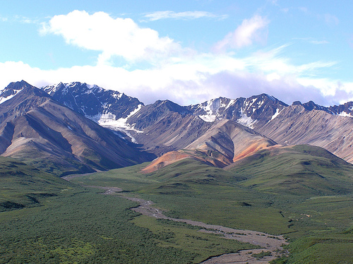
Denali’s topography is defined by extreme elevation contrasts,
ranging from 1,200 feet (366 meters) in the lowlands near the park
entrance to Denali’s 20,310-foot summit. The Alaska Range bisects the
park, creating a rugged spine of peaks, ridges, and valleys:
Denali:
The centerpiece, a granite pluton uplifted over 60 million years, towers
18,000 feet (5,486 meters) above its base—greater relief than Mount
Everest’s—flanked by the Ruth, Kahiltna, and Muldrow Glaciers.
Other
Peaks: Mount Foraker (17,400 feet/5,304 meters), Mount Hunter (14,573
feet/4,442 meters), and Mount Crosson (12,352 feet/3,765 meters) form a
high-altitude cluster, part of the Denali Massif.
Lowlands: North of
the range, rolling hills and flat tundra drop to 1,500–2,500 feet
(457–762 meters), dotted with kettle lakes and braided rivers.
The park’s terrain is split into two zones by ANILCA (1980): 4 million
acres of strictly protected parkland and 2 million acres of preserve,
allowing subsistence activities. The Alaska Range acts as a climatic and
ecological divide, with steep southern slopes facing the Gulf of Alaska
and gentler northern plains opening to the Interior.
Glaciers sculpt Denali’s geography, covering about 16% of the park (1 million acres). The Kahiltna Glacier, at 44 miles (71 kilometers) long, is the longest in the Alaska Range, flowing southwest from Denali’s base. The Ruth Glacier, with its 4,000-foot (1,219-meter) deep Great Gorge, carves a stunning valley, while the Muldrow Glacier, 34 miles (55 kilometers) long, stretches north, its retreat exposing moraines and kettle ponds. These glaciers, fed by heavy snowfall (up to 600 inches/15 meters annually on Denali), shape the park’s rugged peaks and valleys, though warming has shrunk them—Kahiltna lost 1,200 feet (366 meters) since 1950.
Denali’s rivers, born from glacial melt and rainfall, drain into
three major watersheds:
Tanana River System: Northern rivers like the
Kantishna, Toklat, and Teklanika flow into the Yukon River basin,
braiding across tundra with gravel bars and oxbows.
Susitna River
System: Southern streams, including the Chulitna, feed into Cook Inlet,
cutting steep canyons through the range.
Kuskokwim River System:
Western drainages like the McKinley River flow southwest, supporting
wetlands and lakes.
Wonder Lake, at Mile 85 of the park road, is
a glacial jewel reflecting Denali on clear days, while smaller kettle
lakes—formed by melting ice blocks—dot the lowlands, hosting waterfowl
and moose.
Denali’s elevation and climate foster distinct ecological zones:
Taiga Forest: Below 2,500 feet (762 meters), spruce (white and black),
birch, and aspen dominate, with a mossy understory and willow thickets
along rivers, covering the northern lowlands and park entrance.
Tundra: Above 2,500 feet, treeless expanses of dwarf birch, blueberry
shrubs, and lichens stretch across rolling hills and plateaus, vibrant
with wildflowers (fireweed, lupine) in summer.
Alpine Zone: Above
7,000 feet (2,134 meters), barren rock and sparse vegetation—mosses,
grasses—yield to ice and snow on peaks, supporting only hardy lichens.
Permafrost underlies much of the tundra, thawing in summer to form
bogs and muskeg, while glacial silt colors rivers a milky grey.
Denali’s subarctic climate (Köppen Dfc) features extreme seasonal
shifts:
Summer (June–August): Temperatures average 50–65°F (10–18°C)
in lowlands, with 18–20 hours of daylight. Rainfall is 15–20 inches
(380–510 mm), peaking in July.
Winter (November–March): Lows plummet
to -40°F (-40°C), with highs of 0–20°F (-18 to -7°C). Snowfall averages
70–100 inches (1.8–2.5 meters) in lowlands, far more on peaks, under 4–6
hours of light.
Shoulder Seasons: Spring (April–May) and fall
(September–October) are transitional, with rapid weather shifts—sun one
moment, blizzards the next.
The Alaska Range blocks moist Pacific
air, creating a drier Interior (15–20 inches annual precipitation)
versus wetter southern slopes (up to 80 inches). Denali’s height
generates its own weather, shrouding the peak in clouds 70% of the time.
Denali’s geography supports a rich subarctic fauna, famously dubbed
the “Denali Big Five”: grizzly bears, moose, caribou, Dall sheep, and
wolves. Grizzlies roam tundra and forests, numbering 300–350, while
2,000 moose browse willow thickets. Caribou herds (2,500–3,000) migrate
across the park, and 2,000 Dall sheep graze alpine slopes. Wolves
(70–100 in packs) hunt these prey, their howls a park signature. Smaller
mammals—foxes, lynx, marmots—and 160+ bird species (golden eagles,
ptarmigan) thrive, with Wonder Lake a migratory stop.
The park’s
intact ecosystem, free of major human alteration, is a global rarity,
preserved by its remoteness and strict protections, earning UNESCO
Biosphere Reserve status in 1976.
The Denali Park Road, a 92-mile (148-kilometer) gravel lifeline, is
the park’s sole artery, running from the entrance (Mile 1) to Kantishna
(Mile 92). Restricted to shuttle buses beyond Mile 15 since 1972, it
winds through taiga, crosses the Savage and Toklat Rivers, and skirts
the Polychrome Overlook’s colorful volcanic cliffs. Key stops include:
Eielson Visitor Center (Mile 66): At 3,733 feet (1,138 meters), it
offers Denali views on clear days.
Wonder Lake (Mile 85): A glacial
basin with campsites.
Kantishna: A historic gold-mining enclave with
private lodges.
The entrance at Mile 1 hosts the main visitor center,
Murie Science and Learning Center, and Riley Creek Campground, the only
year-round facility. The park’s vastness—94% wilderness—limits
infrastructure, preserving its wild character.
A US Army helicopter flew the Magic Bus out of the national park in June 2020. The bus was used in the film Into the Wild and became famous for that. The young dropout Christopher McCandless lived alone in the abandoned bus in 1992. The onset of snowmelt cut off his return journey across the Teklanika River and he died. After the film was released in 2007, the bus became a place of pilgrimage for outdoor enthusiasts and adventure seekers. A dozen people had to be rescued on the way to the "Magic Bus" each season. Crossing the mountain river in particular is dangerous. In 2010 a Swiss woman died and in 2019 a Belarusian.[