Location: Minnesota Map
Area: 1,090,000 acres (4,410 km²)
Info: (800) 777 7281
(218) 626 4300
The Boundary Waters Canoe Area Wilderness (BWCAW), located in northeastern Minnesota within the Superior National Forest, is a 1.1-million-acre wilderness area renowned for its pristine lakes, dense forests, and unparalleled opportunities for canoeing, camping, and solitude. Established as a protected wilderness in 1964 under the Wilderness Act, with further protections in 1978, the BWCAW is one of the most visited wilderness areas in the United States, offering a rare blend of natural beauty, ecological significance, and cultural history. Stretching along the U.S.-Canada border adjacent to Ontario’s Quetico Provincial Park, it forms part of a vast international wilderness complex.
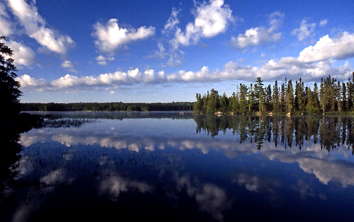
The BWCAW is a mosaic of over 1,100 glacially carved lakes,
interconnected by rivers, streams, and portages, set within a rugged
landscape of boreal forest and exposed bedrock. Its geography is shaped
by ancient geological processes, including glacial activity from the
last Ice Age, which scoured the region’s granite and left behind a
network of waterways. Key features include:
Lakes and Waterways:
The BWCAW contains approximately 1,175 lakes, ranging from small ponds
to large bodies like Lac La Croix, Saganaga, and Basswood Lake. These
lakes are linked by rivers, streams, and over 1,500 miles of canoe
routes, with portages (land trails) allowing travel between water
bodies. About 20% of the area is water, making it a paddler’s paradise.
Terrain: The landscape is characterized by rolling hills, granite
outcrops, and low ridges, with elevations ranging from 1,000 to 2,200
feet. Exposed bedrock, often part of the Canadian Shield, is visible on
lake shores and cliffs.
Wetlands and Bogs: Marshes, bogs, and fens
dot the region, supporting unique plant communities and serving as
critical habitats for wildlife.
Border Region: The BWCAW shares a
150-mile boundary with Canada, with lakes like Knife Lake and Basswood
Lake straddling the border. The area is contiguous with Quetico
Provincial Park, creating a transboundary wilderness of over 2 million
acres.
The region’s waterways flow north into Hudson Bay or south
into Lake Superior, reflecting its position on a continental divide. Its
isolation—no roads penetrate most of the interior—preserves its wild
character.
The BWCAW lies within the transition zone between boreal and
temperate forests, supporting a rich diversity of flora and fauna
adapted to its harsh climate and short growing season. Key ecological
features include:
Flora: The forest is dominated by conifers like
red pine, white pine, jack pine, spruce, and balsam fir, mixed with
hardwoods such as birch, aspen, and maple. Wetlands host sphagnum moss,
wild rice, and carnivorous plants like pitcher plants. The region’s
iconic red pine stands are remnants of old-growth forests, though
logging and fire have altered much of the landscape.
Mammals: The
BWCAW is home to moose, black bears, gray wolves, lynx, beavers, otters,
and red foxes. Smaller mammals like pine martens, fishers, and snowshoe
hares are also common. Moose populations have declined due to climate
change and parasites, while wolves remain a symbol of the area’s
wildness.
Birds: Over 200 bird species inhabit the region, including
common loons (Minnesota’s state bird), bald eagles, ospreys, great gray
owls, and migratory warblers. Wetlands attract waterfowl like mergansers
and wood ducks.
Fish: Lakes teem with walleye, northern pike,
smallmouth bass, lake trout, and panfish, making the BWCAW a premier
fishing destination. Native species face competition from introduced
fish in some lakes.
Ecosystem Dynamics: Fire is a natural force, with
historic wildfires shaping the forest mosaic. Climate change is
lengthening fire seasons and altering lake ice cycles, impacting aquatic
ecosystems.
The BWCAW’s intact ecosystems are a stronghold for
species facing habitat loss elsewhere, but invasive species (e.g., spiny
water flea) and warming temperatures threaten biodiversity.
The BWCAW has a deep human history, from Indigenous peoples to
European explorers and modern conservationists. Key cultural aspects
include:
Indigenous Heritage: The region is the ancestral
homeland of the Ojibwe (Anishinaabe), who have lived here for centuries,
fishing, hunting, and harvesting wild rice. Lakes and portages bear
Ojibwe names, like Saganaga (“long lake”) and Kekekabic (“hawk’s nest”).
Sacred sites, including pictographs (rock paintings) on cliffs at Hegman
Lake, reflect their enduring presence. The Ojibwe continue to exercise
treaty rights for fishing and gathering.
Voyageur Era: In the
17th–19th centuries, French-Canadian voyageurs used the BWCAW’s
waterways as a fur trade route, paddling birchbark canoes along the
“Voyageurs Highway” to link the Great Lakes with Canada’s interior.
Portages like the Grand Portage (outside the BWCAW) were critical to
this network.
Logging and Mining: From the late 19th to early 20th
centuries, logging decimated old-growth pines, and mining explored the
region’s iron and copper deposits. These activities left scars but also
spurred conservation efforts.
Conservation History: The BWCAW’s
protection was a hard-fought victory, driven by figures like Sigurd
Olson, a writer and advocate who championed its wilderness status. The
1978 BWCAW Act banned motorized vehicles in most areas, preserving its
primitive character, though debates over motorboat use persist.
The
area remains a living cultural landscape, with Ojibwe communities
advocating for co-management and protection of treaty rights.
The BWCAW is a world-class destination for canoeing, camping,
fishing, and wilderness exploration, attracting about 250,000 visitors
annually. Its vast network of waterways and campsites offers endless
routes, from short day trips to multi-week expeditions. Key activities
include:
Canoeing and Kayaking: The BWCAW’s interconnected lakes
and rivers support over 1,500 miles of canoe routes, with portages
(ranging from a few yards to over a mile) linking water bodies. Popular
entry points include Ely, Gunflint Trail, and Sawbill Lake. Routes range
from beginner-friendly loops (e.g., Poplar Lake) to challenging border
routes (e.g., Lac La Croix to Crane Lake). Canoes are preferred over
kayaks for carrying gear across portages.
Camping: The BWCAW has over
2,000 designated campsites, each with a fire grate and latrine, spread
across lakeshores. Sites are first-come, first-served, requiring
flexibility. Backcountry camping follows Leave No Trace principles, with
strict rules on waste and fire management.
Fishing: Anglers target
walleye, pike, bass, and trout, with lakes like Basswood and Saganaga
known for trophy fish. A Minnesota fishing license is required, and
catch-and-release is encouraged for sensitive species like lake trout.
Hiking: While canoeing dominates, hiking trails like the Kekekabic Trail
(41 miles), Border Route Trail (65 miles), and Powwow Trail offer rugged
backcountry treks through forests and overlooks. Trails are less
maintained than canoe routes and require navigation skills.
Wildlife
Viewing: Moose, loons, and eagles are commonly spotted, especially at
dawn or dusk. Wolf howls are a thrilling nighttime experience.
Binoculars and patience enhance sightings.
Winter Activities: From
December to March, the BWCAW transforms into a winter wonderland for
cross-country skiing, snowshoeing, and ice fishing. Frozen lakes allow
travel by ski or dog sled, though extreme cold (down to -30°F) demands
expertise.
Access requires permits (available online via
recreation.gov), with quotas limiting daily entries to manage
overcrowding. Summer (June–August) is peak season, with warm weather
(60–80°F) and long days, while fall (September–October) offers vibrant
foliage and fewer bugs. Outfitters in Ely, Grand Marais, and Tofte
provide rentals, guides, and shuttles.
The BWCAW’s pristine state faces ongoing threats, requiring vigilant
management by the U.S. Forest Service and advocacy groups. Key
challenges include:
Climate Change: Warming temperatures are
reducing lake ice duration, disrupting fish spawning and winter
recreation. Increased wildfire risk, as seen in the 2011 Pagami Creek
Fire (93,000 acres burned), threatens forests and campsites.
Invasive
Species: Aquatic invasives like spiny water flea and zebra mussels,
introduced via boats, harm native fish and plankton. Visitors must clean
gear to prevent spread.
Mining Proposals: Copper-nickel mining near
the BWCAW’s southern boundary, particularly the Twin Metals project,
risks polluting waterways with sulfuric acid runoff. Legal battles and
public opposition continue to block these plans.
Overuse: High
visitation strains campsites, portages, and water quality. Litter,
improper waste disposal, and campfire scars are persistent issues,
prompting stricter regulations.
Motorized Use: Limited motorboat use
is allowed on certain lakes (e.g., Saganaga, Basswood), but debates over
expanding motorized access threaten the area’s wilderness character.
Conservation efforts focus on trail maintenance, invasive species
control, and fire management. Advocacy groups like Friends of the
Boundary Waters and Save the Boundary Waters work to protect the area
from mining and overuse, while engaging Ojibwe communities in
co-stewardship.
Access: Entry points are reached via roads from Ely, Grand Marais, or
Tofte. Common entry points include Moose Lake, Sawbill Lake, and
Gunflint Lake. Air travel to Duluth (120 miles away) is the nearest
major hub.
Permits: Required for overnight trips (May 1–September
30), costing $16 per adult plus a $6 reservation fee (2025 rates).
Day-use permits are free but recommended. Quotas limit entries at each
point.
Facilities: No developed facilities exist beyond entry-point
parking and basic latrines at campsites. Visitors must be
self-sufficient, with water filters and bear-proof food storage (e.g.,
Ursack or hanging bags).
Weather: Summer brings warm days (60–80°F)
and cool nights, with frequent rain and mosquitoes. Fall is crisp
(40–60°F) with stunning colors. Winter is harsh, with heavy snow and
subzero temperatures.
Safety: Hazards include rough portages,
cold-water immersion, and bear encounters. Carry maps, compasses, or
GPS, as cell service is unreliable. Lightning and wildfires are summer
risks.