Location: North Wisconsin Map
Kayaking, rafting location: Langlade
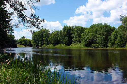
The Wolf River is a prominent waterway in northeastern Wisconsin, renowned for its pristine natural beauty, ecological significance, and recreational opportunities. Stretching 225 miles (362 km) from its headwaters in central Forest County to its confluence with the Fox River near Winneconne in Winnebago County, it is one of the state's most iconic rivers. Known in the Menominee language as Mahwāēw-Sēpēw (meaning "wolf river"), it drains a vast basin of approximately 3,690 square miles, encompassing parts of 11 counties: Forest, Langlade, Marathon, Menominee, Oneida, Outagamie, Portage, Shawano, Waupaca, Waushara, and Winnebago. The river is celebrated as one of only two National Scenic Rivers in Wisconsin (the other being the St. Croix River), designated under the Wild and Scenic Rivers Act of 1968 to preserve its free-flowing character and outstanding natural, cultural, and recreational values. It flows through diverse landscapes, from rugged northern forests to fertile agricultural lowlands, and plays a vital role in the region's economy, ecology, and cultural heritage.
The Wolf River originates in a series of springs, spring seeps, and
exposed aquifers in the glacial sands and gravels of central Forest
County, near the town of Crandon. It generally flows southward, carving
a meandering path through a variety of terrains before joining the Fox
River at Lake Butte des Morts, an impoundment near Winneconne, at an
elevation of about 748 feet (228 m). The river's basin is part of the
larger Fox-Wolf watershed, which ultimately connects to Lake Michigan
via the Fox River and Green Bay, and further to the Atlantic Ocean
through the Great Lakes system and the St. Lawrence River.
The basin
spans the Northern Lakes and Forests and North Central Hardwood Forests
ecoregions, featuring a mix of coniferous and deciduous forests,
extensive wetlands, marshes, and open farmlands. In the north, it
traverses the nearly 233,000-acre Menominee Indian Reservation (almost
entirely within the basin) and portions of the 655,000-acre
Chequamegon-Nicolet National Forest (formerly Nicolet). The river's
gradient is relatively high in its upper reaches, creating rapids and
falls, while it becomes slower and wider in the south, forming part of
the Winnebago Pool—a chain of lakes including Poygan, Winneconne, and
Butte des Morts.
Major tributaries include the Waupaca River, Little
Wolf River, Embarrass River, Shioc River, Red River, Evergreen River,
Lily River, Hunting River, Pine River, Rat River, Wildcat Creek, and
Pine Creek, among others, with sub-basins ranging from 71 to 313 square
miles in size. Human modifications include several dams, such as the
Shawano Dam (built in the late 1800s) and Balsam Row Dam, which create
reservoirs like Shawano Lake but have historically impeded fish
migration. The river's flow is influenced by seasonal variations, with
spring thaws boosting water levels for recreation and fall low flows
exposing rocky beds.
Notable geological features include its passage
over the Precambrian Canadian Shield in the upper sections, where
granite, gneiss, gabbro, and metamorphosed sedimentary rocks (including
the Wolf River Batholith, a type of pink "Wolf River granite") form
dramatic rapids, waterfalls, and gorges. Keshena Falls, located within
the Menominee Reservation, is a key landmark where the river drops over
rocky outcrops.
The Wolf River's history is intertwined with indigenous peoples,
European settlement, industrialization, and modern conservation. The
Menominee Tribe has inhabited the area for millennia, viewing the river
as a sacred resource for sustenance and ceremony—sturgeon captured at
Keshena Falls, for instance, are used in traditional meals. European
exploration and logging boomed in the 19th century; during the Civil War
era (1863), Congress funded a military trail along the river to
transport Union troops from Michigan's Upper Peninsula to Green Bay,
though it was later used primarily by loggers and completed in the
1870s.
The late 1800s saw extensive logging drives, with dams built
to float massive timber volumes—estimated at half a billion board feet
in 1873—to mills in Oshkosh. This era degraded water quality and
habitats, but by the early 20th century, restoration began with the
removal of logging dams (the last in 1926). The 1930s drought led to
water diversions for agriculture, and post-WWII pesticide use further
threatened the ecosystem.
Conservation gained momentum in the 1960s,
with U.S. Secretary of the Interior Stewart Udall and Senator Gaylord
Nelson advocating for protection. In 1967, $500,000 was allocated to
preserve nearly 90 miles of the river and its tributaries in Langlade
and Menominee Counties. The 1968 National Scenic River designation
followed. A major modern battle was against the proposed Crandon mine
near the headwaters in the 1990s–2000s, which threatened water quality
with acid mine drainage. A coalition of tribes (including the Menominee
and Sokaogon Mole Lake Chippewa), environmentalists, and locals halted
it; in 2003, the Sokaogon purchased the site to prevent development, a
story chronicled in To Slay a Giant by John J. Mutter, Jr.
Two towns
bear the river's name: Wolf River in Langlade County (population ~731 as
of 2010) and another in Winnebago County, reflecting its cultural
footprint.
The Wolf River supports a rich, biodiverse ecosystem, though it faces
ongoing challenges. It is a critical spawning ground for the world's
largest population of lake sturgeon, which migrate upstream from Lake
Winnebago each spring (April 15–May 5) to sites like Keshena Falls.
Restoration efforts since 2012, led by the Wisconsin DNR and Menominee
Tribe, involve capturing and relocating sturgeon above dams like Shawano
and Balsam Row, with successful spawning documented at Keshena. Other
key species include walleye (spring spawning runs), white bass, brown
trout, rainbow trout, brook trout, and a state-record quillback caught
in 2016 (25 inches, 9 lbs 15.8 oz).
The basin's wetlands, floodplain
forests, and hardwood stands host diverse vegetation, from open marshes
and grassy lowlands to dense thickets and coniferous forests. Birding is
exceptional, with opportunities to spot migratory species. Invasive
zebra mussels, first detected in the Winnebago Pool (including the Wolf)
in 1999, clog intakes and disrupt food webs. Land use—primarily forestry
and agriculture (dairy and cash crops)—impacts water quality, but the
basin's 50,000+ acres of public conservation lands, managed by the DNR,
include wildlife areas, state parks, and fisheries access sites. The
Wolf River Wildlife Area offers habitats for birds, fish, and mammals,
emphasizing preservation.
The Wolf River is a premier outdoor destination, generating over $399
million in tourism income and 10,500 jobs in the basin as of 1993
estimates, with growth since. Its 40 miles of whitewater rapids (Class
I–IV) in Langlade and Menominee Counties attract paddlers worldwide,
divided into four sections:
Section 1 (Upper Wolf, 10 miles): Class
I–II rapids through pine plantations and hardwood forests;
beginner-friendly.
Section 2 (8 miles): Similar easy rapids; ideal
for tubing.
Section 3 (10 miles): Class II+ to III; more challenging
with boulder gardens.
Section 4 (12 miles, Menominee Reservation):
Class III–IV; requires a tribal permit and fee, featuring the infamous
"Big Smokey" rapid.
Outfitters offer rafting, kayaking, canoeing,
and tubing trips. Fishing is world-class, especially sturgeon spearing
on Lake Winnebago (tied to river runs), walleye, and trout in upper
reaches. Other activities include hiking, birding, hunting,
cross-country skiing, camping, swimming, and nature study in areas like
the Wolf River State Trail and Wildlife Area. The Sturgeon For Tomorrow
program protects spawning sites annually. Scenic drives along rural
roads reveal changing seasons, family farms, and sunrises over wide-open
spaces.
As a National Scenic River, the 24-mile segment from the
Langlade-Menominee County line to Keshena Falls is managed to remain
undeveloped, emphasizing its rugged beauty, cultural sites (including
protected archaeological resources on the Menominee Reservation), fish
habitats, and geology. The designation prohibits dams or diversions that
impair its values. Broader efforts include DNR-managed lands, tribal
stewardship, and anti-mining campaigns. Water quality monitoring
addresses agricultural runoff and invasives, ensuring the river's role
as a "great outdoor recreation area" endures.
In summary, the Wolf
River embodies Wisconsin's wild heart—a free-flowing artery sustaining
life, history, and adventure while facing the pressures of development.
Its preservation reflects a commitment to balancing human enjoyment with
ecological integrity.