Location: Upper Peninsula Map
Porcupine Mountains Wilderness State Park, affectionately known as "the Porkies," is Michigan's largest state park and one of the most pristine wilderness areas in the Midwest. Spanning approximately 60,000 acres (about 24,000 hectares) across Ontonagon and Gogebic counties in the western Upper Peninsula, it borders Lake Superior for nearly 20 miles along its southern edge. Established in 1945 and redesignated as a wilderness area in 1972 under Michigan's Wilderness and Natural Areas Act, the park protects one of the last extensive stands of old-growth northern hardwood forest in North America west of the Adirondack Mountains—covering at least 35,000 acres of uncut timber. Designated a National Natural Landmark in 1984, it serves as a cooperating unit of the Keweenaw National Historical Park due to its ties to regional copper mining history. The park attracts over 400,000 visitors annually, drawn to its dramatic landscapes, diverse ecosystems, and year-round recreational opportunities, while emphasizing low-impact wilderness preservation.
The Porcupine Mountains rise abruptly from the surrounding lowlands,
forming a rugged escarpment that parallels the Lake Superior shoreline,
with peaks reaching up to 1,958 feet (597 meters) at Summit Peak—the
highest point in the park and the second-highest in Michigan's Upper
Peninsula. The range's name derives from the Ojibwa (Chippewa) people,
who likened the silhouette of its jagged ridges to a crouching
porcupine. Geologically, the mountains are remnants of an ancient
stratovolcano from the Midcontinent Rift, about 1.1 billion years old,
featuring basalt, conglomerate, and copper-bearing bedrock similar to
that on the nearby Keweenaw Peninsula. This creates a dramatic
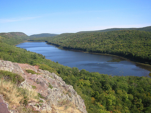
topography of steep ridges, deep gorges, glacial valleys, and over 25
inland lakes, including the iconic Lake of the Clouds—a shallow,
bog-fringed body of water nestled in a hanging valley at 1,600 feet
elevation, offering panoramic vistas of the surrounding wilderness.
The park's hydrology is equally impressive, with several wild rivers
tumbling over waterfalls and cascades before emptying into Lake
Superior. The Presque Isle River, originating in the Ottawa National
Forest to the west, flows eastward through the park's northern section,
carving a scenic gorge with five major waterfalls (including the 50-foot
Manabezho Falls) over its 15-mile course within park boundaries. Other
notable waterways include the Black River (with its own series of
waterfalls like the 30-foot Potawatomi Falls) and the Big Carp River,
which bisects the park and feeds into Lake Superior. The landscape
transitions from the high, forested ridges in the interior to sandy
beaches, rocky cliffs, and wetlands along the lakefront. The park
receives heavy lake-effect precipitation from Lake Superior, resulting
in annual snowfall exceeding 200 inches (510 cm) at lower elevations and
up to 250 inches (640 cm) or more in the highlands, though official
records are not kept due to the remote terrain. Summers are mild, with
average highs around 75°F (24°C), while winters can plunge below 0°F
(-18°C), fostering a subarctic-like environment in spots.
Human presence in the Porcupine Mountains dates back thousands of
years, with archaeological evidence of Native American habitation by the
Ojibwa and earlier Woodland cultures who used the area for hunting,
fishing, and seasonal camps. European exploration began in the 17th
century with French fur traders and Jesuit missionaries, but significant
settlement occurred in the 19th century amid the Copper Rush. The
Nonesuch Mine, one of the region's few successful copper operations,
extracted ore sporadically from 1867 to 1912, leaving behind remnants
like mine shafts and tailings that are now historical sites. Logging
interests eyed the vast old-growth forests in the late 1800s, but the
remote location and rugged terrain spared much of it from widespread
clear-cutting that devastated other parts of Michigan.
Conservation
efforts ramped up in the early 20th century. In 1927, the state acquired
initial lands for a forest preserve, but it was the 1945 legislative act
that formalized the park's creation, dedicating 46,000 acres to
safeguard the "biggest and best remaining old-growth hardwood-hemlock
forest in the Midwest." Expansion brought it to its current size by the
1970s. The wilderness designation in 1972 prohibited further
road-building or commercial logging in core areas, preserving its wild
character. In the 1980s, the park gained National Natural Landmark
status for its ecological and geological significance. Modern history
includes the development of the Porcupine Mountains Ski Area in 1982,
managed by Gogebic Community College's program, which provides
educational opportunities while maintaining environmental standards. No
major controversies are noted in recent records, though ongoing
management balances tourism with habitat protection, including wolf
reintroduction monitoring since the 1990s.
The Porcupine Mountains boast one of the most biodiverse ecosystems
in the Great Lakes region, serving as a critical corridor for wildlife
migration between Lake Superior and inland forests. Its old-growth
forest—dominated by towering eastern hemlocks (up to 400 years old and
150 feet tall), sugar maples, yellow birches, American basswoods, and
white pines—forms a multi-layered canopy that supports rare understory
plants like the endangered ram's head lady's slipper orchid, Hooker's
fairy-bells, and slender cliff brake fern. Wetlands and bogs harbor
carnivorous plants such as pitcher plants, while the lakes and rivers
teem with brook trout, walleye, and northern pike.
Fauna is equally
remarkable, with the park acting as a stronghold for apex predators and
keystone species. Gray wolves, reintroduced regionally in the 1990s,
maintain a stable pack presence, often heard howling at night. Moose,
black bears, white-tailed deer, and bobcats roam the uplands, while
river otters, beavers, and fishers thrive along waterways. Smaller
mammals include porcupines (fitting the park's name), red and gray
foxes, martens, minks, lynx, and coyotes; cougar sightings are rare but
increasing. Birdlife is prolific, with over 150 species recorded,
including bald eagles, peregrine falcons (a recovering threatened
species), merlins, and migratory warblers. Reptiles and amphibians, such
as the special-concern wood turtle, inhabit the moist lowlands. The
park's isolation and minimal development help mitigate threats like
climate change and invasive species (e.g., emerald ash borer), though
monitoring programs track impacts from heavy snowfall and warming
temperatures on forest composition.
Recreation is the park's hallmark, with activities tailored to all
seasons and skill levels, generating significant economic benefits for
the local Ontonagon County economy through tourism. The park features
over 90 miles of maintained trails, including a 17-mile segment of the
4,800-mile North Country National Scenic Trail, ideal for day hikes or
multi-day backpacking. Signature routes include the 4.2-mile Lake of the
Clouds Overlook Trail (an accessible boardwalk to stunning vistas) and
the challenging 9-mile Escarpment Trail, which traverses the ridge tops
with views of Lake Superior and ancient forests. Waterfall chasers can
follow the 2.5-mile Black River National Forest Scenic Byway to access
cascades like Gorge Falls and the rare Superior Jumping-off Rocks, where
daredevils once plunged into the river (now prohibited).
Summer
pursuits include swimming and boating on Lake Superior's beaches at
Union Bay or East River, fishing in the rivers and lakes (with trout and
salmon runs), and paddling the Presque Isle or Carp Rivers. Mountain
biking is permitted on designated trails, and rock climbing
opportunities exist on the cliffs. Winter transforms the park into a
snowshoeing and cross-country skiing paradise, with 42 km of groomed ski
trails and 26 km of snowshoe routes; the ski area offers 11 downhill
runs and a terrain park for all abilities. Backcountry camping is
popular, with 83 rustic sites, 18 yurts, and five wilderness cabins
available by reservation—requiring backpacking access to promote
solitude. The Porcupine Mountain Music Festival, held annually in
summer, adds a cultural twist with folk and roots music performances.
Facilities include the modern Porcupine Mountains Visitor Center (with
exhibits on natural and cultural history), a park store, and Union Bay
Campground (with 200+ sites, showers, and RV hookups). Day-use areas
feature picnic shelters and interpretive programs led by rangers, such
as guided hikes and wildlife talks. Entrance fees apply (about $17/day
for non-residents as of 2025), and backcountry permits are required.
Accessibility options include boardwalks and an observation deck at
Summit Peak, equipped with a 360-degree tower for views up to 50 miles
on clear days.
As a designated wilderness area, the Porcupine Mountains are managed by the Michigan Department of Natural Resources (DNR) to maintain its "primitive, undeveloped" character, prohibiting motorized vehicles, new roads, or resource extraction in sensitive zones. The park's 35,000-acre old-growth core is a testament to successful conservation, with ongoing efforts like prescribed burns to mimic natural disturbances and invasive species control. It collaborates with the U.S. Forest Service on adjacent Ottawa National Forest lands and supports research on wolf ecology and climate resilience. Visitor guidelines emphasize Leave No Trace principles to preserve the solitude—defined as encountering fewer than six other parties per day in backcountry areas. Future challenges include adapting to climate-driven changes, such as shorter winters affecting the ski economy, but the park's robust protection ensures it remains a vital refuge for biodiversity and a gateway to Michigan's wild heritage.