Location: Newton, Searcy, Marion, and Baxter Counties Map
Length: 150 miles (240 km)
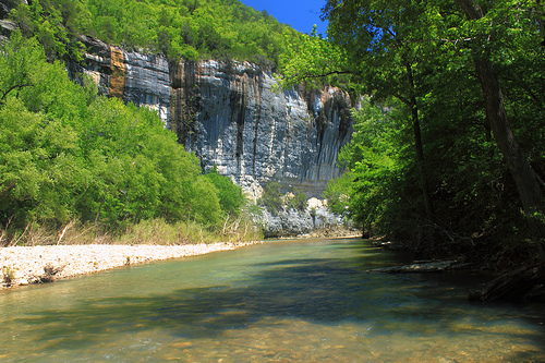
Buffalo National River, located in northern Arkansas, is a 135-mile (217 km) stretch of pristine, free-flowing waterway that winds through the Ozark Mountains, celebrated as America's first national river. Established by Congress on March 1, 1972, under Public Law 92-237, it was designated to protect one of the few remaining undammed rivers in the lower 48 states, preserving its natural, scenic, and recreational values from proposed dam construction that threatened its wild character. The river originates in the Boston Mountains of Newton County and flows eastward through rugged terrain in Newton, Searcy, Marion, and Baxter counties before joining the White River near Buffalo City, covering a total watershed of about 1,500 square miles (3,885 km²). Managed by the National Park Service (NPS) as a unit of the national park system, the 95,586-acre (38,698 ha) park encompasses diverse landscapes of towering limestone bluffs, deep valleys, waterfalls, caves, and old-growth forests, offering solitude and adventure. It attracts over 1.5 million visitors annually, generating significant economic benefits for rural communities while embodying the Ozarks' timeless beauty—often called the "gem of the Ozarks."
The Buffalo National River traces a meandering 135-mile path through
the heart of the Ozark Plateau, a dissected upland region of karst
topography formed by the dissolution of soluble limestone over millions
of years. Originating at the confluence of Richland Creek and Calf Creek
in the Boston Mountains (part of the larger Ozark ecoregion), the river
flows generally northeastward, dropping about 1,200 feet (366 m) in
elevation from its source at around 2,000 feet (610 m) to its mouth at
500 feet (152 m). The protected segment begins near the western boundary
in Newton County and ends at White River Lake, excluding the lower 18
miles due to private land and impoundments. Along its course, the river
carves dramatic canyons up to 500 feet (152 m) deep, flanked by sheer
bluffs of Pennsylvanian-age limestone and sandstone, riddled with over
300 caves, arches, and springs—features like the 60-foot (18 m)
Hemmed-in-Hollow Falls (the tallest waterfall between the Appalachians
and Rockies) and the multi-tiered Roaring River Falls exemplify its
scenic splendor.
The river's hydrology is influenced by its karst
geology, with groundwater from aquifers feeding numerous springs that
maintain base flows even in dry periods, though flash floods from Ozark
thunderstorms can swell it dramatically (up to 30 feet/9 m in hours).
Tributaries like the Mulberry, Crooked Creek, and Little Buffalo add
volume, creating diverse reaches: the upper sections near Ponca feature
Class II–III rapids and boulder gardens ideal for whitewater; the middle
stretches around Steel Creek offer calmer pools for swimming; and the
lower portions near Buffalo City widen into gravel bars and sandbanks
suitable for families. The watershed's thin soils and steep slopes (up
to 60% grade) contribute to erosion risks, but the park's 36,000 acres
of designated wilderness (including Buffalo Point and Upper Buffalo
units) preserve its rugged, unglaciated landscape. Climate is humid
subtropical, with mild winters (average lows 25°F/-4°C) and hot summers
(highs 90°F/32°C), annual rainfall of 45–50 inches (114–127 cm), and
vibrant fall foliage in October.
The Buffalo River's human history spans millennia, beginning with
Paleo-Indian hunters around 10,000 years ago who followed megafauna like
mastodons into the Ozarks, leaving behind Clovis points and atlatl
weights in caves and overhangs. Woodland and Mississippian cultures
(A.D. 500–1500) established villages along the river, evidenced by
pottery, arrowheads, and burial mounds, with the Osage and Quapaw tribes
using it for hunting and trade by the 1700s. French explorers like Henri
de Tonti mapped the area in 1686, naming it "Riviere des Bergs" (River
of the Mountains), but European settlement was sparse until the early
1800s, when pioneers cleared land for farms and mills, exploiting the
river for hydropower—sites like the Boxley Grist Mill (1873) and Murray
Mill (1900s) reflect this era of homesteading and moonshining during
Prohibition.
The 20th century brought threats: In the 1930s, the
Civilian Conservation Corps (CCC) built trails and structures at Buffalo
Point, aiding Depression-era infrastructure, but post-WWII Army Corps of
Engineers plans for three dams (to generate power and control floods)
imperiled the river's wildness. Conservationists, led by the Ozark
Society (founded 1962 by Neil Compton) and figures like Jimmy Carter
(who floated the river as president), mobilized against it, culminating
in the 1972 designation after a decade-long fight that involved land
acquisitions from over 800 landowners. This "people's victory" preserved
95,000+ acres, though challenges persist, such as the 2010s hog farm
pollution controversy near Mount Judea, resolved by 2019 closure. In
2025, the park honors its 53rd anniversary with ongoing oral history
projects and CCC commemorations.
Buffalo National River's ecology is a biodiversity hotspot in the
Ozark-Ouachita Highlands ecoregion, featuring mixed hardwood forests
of oak-hickory (covering 80% of the park), shortleaf pine stands,
and riparian zones with sycamore, river birch, and canebrakes—home
to over 800 plant species, including rare endemics like the Arkansas
trillium and sensitive fern in bluff shelters. The karst landscape
harbors over 300 caves (e.g., Fitton Cave with its blind fish and
eyeless shrimp) and 58 springs, supporting unique aquatic habitats
with clear, oligotrophic waters (low nutrients, high oxygen) that
foster caddisflies, mayflies, and riffle beetles as indicators of
pristine conditions.
Wildlife thrives in this undeveloped
corridor: The river is a world-class fishery for smallmouth bass (up
to 20 inches/51 cm, with trophy sizes over 5 lbs/2.3 kg),
goggle-eye, walleye, and rainbow trout stocked in colder upper
reaches; herons, kingfishers, and bald eagles patrol the waters,
while otters, beavers, and mink play along banks. Terrestrial
species include white-tailed deer, black bears (reintroduced
regionally), bobcats, gray foxes, and over 200 bird species (e.g.,
cerulean warblers, pileated woodpeckers); the park's old-growth
hemlock groves shelter rare invertebrates like the Arkansas
fatmucket mussel. Threats include invasive species (e.g., feral
hogs, Asian carp), pollution from upstream agriculture (addressed
via watershed management plans), and climate-driven droughts
affecting flows, but monitoring by NPS and partners maintains its
"exceptional" water quality.
Buffalo National River is a paddler's paradise, with 135 miles
divided into six float sections (e.g., 19-mile Ponca to Steel Creek:
Class II rapids; 44-mile Harriet to St. Joe: scenic gravel bars), rated
from beginner-friendly to expert whitewater in spring (March–May, when
flows exceed 350 cfs/10 m³/s). Outfitters like Buffalo Outdoor Center in
Ponca provide canoes, kayaks, and shuttles ($50–$150/trip), while
fishing licenses (Arkansas or reciprocal states) are required for
angling—best in fall for smallmouth on jigs or crankbaits. Hiking spans
100+ miles of trails, from the 37-mile Buffalo River Trail (multi-use
for backpacking) to short loops like the 1.5-mile Hemmed-in-Hollow to
Centerpoint (steep, strenuous); rock climbing on 1,000+ routes at Indian
Creek and Steel Creek attracts climbers, with bouldering in the
wilderness.
Camping includes 13 NPS-developed sites (e.g., Steel
Creek: 36 sites with hookups, $14–$28/night; reservations March–November
via recreation.gov) and 200+ backcountry spots (free, first-come;
permits for groups >7), plus three group campgrounds for 25–100 people.
Visitor centers at Tyler Bend (Harrison headquarters), Buffalo Point,
and Pruitt offer exhibits, ranger programs, and river gauges; no
entrance fee, but shuttles and gear rentals boost local economies. Night
sky viewing is exceptional (Bortle Class 2 skies), with stargazing
events, and equestrian trails add variety. In 2025, tourism surges with
spring floats and fall colors, though flash flood risks prompt safety
alerts.
As a national river, Buffalo is administered by the NPS under the Wild and Scenic Rivers Act, with 36,000 acres of congressionally designated wilderness (1978 expansions) ensuring no further development—two units (Upper Buffalo: 10,000 acres; Buffalo Point: 4,000 acres) managed by the U.S. Forest Service emphasize primitive recreation. The 2018 Watershed-Based Management Plan addresses E. coli from livestock via incentives for best practices, while the NPS's 2025 foundation document prioritizes climate resilience, invasive control, and cultural resource protection (e.g., 19th-century homesteads). Collaborations with the Buffalo National River Foundation fund trail maintenance and education, countering overuse (1.5M visitors) with Leave No Trace campaigns. Recent wins include the 2025 reaffirmation of wilderness protections amid mining threats, safeguarding this "national treasure" for future generations.