Location: Inyo County, CA Map
Found: 1875
Darwin Ghost Town, perched in the stark high desert of Inyo County, southeastern California, is a semi-ghost town that embodies the rugged, ephemeral spirit of the American mining frontier while evolving into an offbeat artist enclave. Situated just 11 miles west of the Death Valley National Park boundary and 22 miles southeast of Lone Pine, this unincorporated community at an elevation of approximately 4,800 feet was once the bustling epicenter of the New Coso Mining District, boasting a peak population of around 3,500 in 1877 amid a silver and lead boom that produced an estimated $15–20 million in ore value over its lifetime. Founded in 1874 after rich silver strikes, Darwin rapidly sprouted saloons, mills, and frame houses, only to fade into obscurity by the mid-20th century as mines depleted and economic tides shifted. Today, with a scant population of 35–45 resilient souls—many artists, writers, and off-grid eccentrics living in colorful, improvised shacks amid the ruins—it clings to life as a quirky "living ghost town," blending decaying adobe and wooden relics with whimsical folk art installations crafted from desert detritus like rusted cars, animal bones, and scrap metal. No gas stations, stores, or modern amenities interrupt the isolation, fostering a profound sense of disconnection under vast, star-filled skies and Joshua tree-dotted horizons. As a Census-designated place with no formal government, Darwin attracts intrepid explorers, photographers, and those seeking an authentic, uncommercialized slice of Wild West history intertwined with contemporary bohemian creativity, all within the dramatic Basin and Range topography that borders the scorching expanses of Death Valley.
Darwin's saga unfolds like a classic Western tale of fortune, frenzy,
and forfeiture, rooted in the post-Civil War mineral rush that
transformed California's arid interiors. The area's story begins in
1859–1860, when Dr. E. Darwin French, a physician and explorer from Fort
Tejon, led a prospecting party from Visalia in search of the fabled
"Lost Gunsight Mine" (or "Silver Mountain"). Though they missed that
legendary vein, French's group uncovered promising silver outcrops in
the Coso Range, staking initial claims and naming the site after
him—Darwin Canyon, Falls, and Wash. By 1870, further discoveries of
gold, silver, and lead ignited the New Coso Mining District, but it was
the 1874 silver bonanza that birthed the town proper. Prospectors
swarmed from nearby Lone Pine and Keeler, erecting a tent city that
exploded into a full-fledged boomtown by late 1875: two smelters
processed ore nonstop, 20 mines operated (including the prolific Essex,
Defiance, and Blackhawk), a post office opened, and infrastructure
followed with graded streets, a drugstore, hotel, three restaurants,
multiple saloons, a newspaper (the Inyo Mountaineer), and over 200 frame
houses housing 700+ residents. The 1876 Centennial Celebration marked
its zenith, with the population surging to 3,500 by 1877, making Darwin
Inyo County's largest and most lawless settlement—gunfights over claims,
stagecoach robberies, and vigilante justice were rife, earning it a
reputation as a "rough and tumble" outpost.
Yet, prosperity proved
fleeting. A devastating smallpox epidemic in 1878 killed dozens and
spurred wage cuts at the mines, igniting labor unrest and violence that
shuttered the newspaper by September. Catastrophe struck on April 30,
1879, when a suspected arson fire razed 14 key buildings, including the
Darwin Hotel, stores, saloons, and post office, accelerating the exodus
to 200–300 residents by late 1878 and just 85 by 1880. The post office
closed in 1902 but reopened amid a copper revival in the early 1900s,
drawing investors like future Nevada Senator Tasker L. Oddie and banker
George Nixon, who poured capital into claims like the Lucky Jim Mine.
Fires in 1917 and 1918 destroyed more structures, but World War I demand
for lead-silver ore sustained operations at mines like the Christmas
Gift and Wagner. The 1926 Eichbaum Toll Road (now CA-190) briefly
boosted tourism with cabins and services, but the Great Depression and
WWII shifted priorities—mines closed temporarily, only to rebound in
1945 when Anaconda Copper Mining Company acquired the Wagner Mine on Mt.
Ophir, turning it into California's leading lead producer (yielding
two-thirds of the state's output until the 1970s). Total ore value from
1870–1945 reached $7 million, with overall estimates hitting $15–20
million by closure in the 1970s. Post-1970s, Darwin transitioned from
industrial relic to artist haven, with hippies and creatives squatting
in ruins during the 1970s counterculture wave, establishing an off-grid
community that persists today, documented in films like the 2011
"Darwin" and books such as Kathy Goss's semi-fictional "Darwoon Dyreez."
Nestled in a remote pocket of the Mojave Desert within the Basin and Range Province, Darwin occupies a rugged, high-desert basin at 36°15′40″N 117°35′30″W, flanked by the Inyo Mountains to the east (rising to 11,000+ feet) and the Coso Range to the west, with Owens Dry Lake's alkaline flats visible to the south. At 4,790 feet elevation, it experiences an extreme arid climate: scorching summers (100°F+ days), frigid winters (sub-freezing nights), scant rainfall (under 5 inches annually), and relentless winds that sculpt the landscape into eroded buttes, volcanic tuffs, and sagebrush plains dotted with Joshua trees and wild burros. The town's 1-square-mile footprint hugs Darwin Wash, a dry creek bed prone to flash floods, while nearby Mt. Ophir (7,329 feet) looms with terraced mine scars. Geologically, the silver-lead deposits formed from Miocene volcanic activity, intruded by quartz veins in Paleozoic limestones—exploited via shafts and adits that honeycomb the hills. This isolation, 200 miles northeast of Los Angeles and buffered by military-restricted China Lake Naval Air Weapons Station to the south, preserves Darwin's untouched aura, though it amplifies challenges like poor cell service and dust storms.
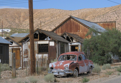
Darwin's haunting remnants evoke a time capsule of mining-era grit, interspersed with vibrant, improvisational art that defies its ghostly label. Downtown's main drag features sagging adobe and wooden facades from the 1870s–1880s, including the original post office (still operational, one of California's oldest), a red-white-and-blue painted "new" post office, and the Darwin Station—a repurposed building housing a tiny library, art studio, and occasional pop-up gallery. Scattered ruins include the shell of the old courthouse (now a residence), saloon foundations, a one-room schoolhouse (built 1912, used until 1930s), and the defunct Essex Hotel site. On Mt. Ophir's slopes, a half-mile northwest, lie the decaying Anaconda company camp: rows of weathered frame houses, Quonset huts, and mill buildings amid rusted machinery, tailings piles, and the skeletal Defiance Smelter (built 1875). The hillside cemetery, a short hike away, holds 100+ graves from the 1870s–1930s, marked by wooden headboards and iron fences, offering poignant vignettes of boomtown mortality. Modern twists shine in the artist colony: sculptor Jim Hunolt's marble, bronze, and granite abstractions grace a sculpture garden; writer Kathy Goss's bone-and-appliance assemblages dot yards; and ad-hoc murals and junk sculptures adorn shacks, turning decay into dialogue. Nearby, the 1877 Assayer's Office ruin and scattered mine portals (like the Blackhawk) invite cautious exploration, while rusting hulks of 1920s–1950s vehicles add photogenic patina.
Darwin rewards self-reliant adventurers with low-key, immersive pursuits that blend historical sleuthing and creative inspiration. The core activity is a 1–2 mile self-guided walking tour of downtown and the Mt. Ophir camp, tracing graded paths past ruins and art installations—allow 2–4 hours to photograph graffiti-scarred walls, peer into mine adits (stay out for safety), and chat with residents if they're welcoming (many are private but hospitable to respectful visitors). Hiking enthusiasts can tackle moderate trails to the cemetery or up Darwin Canyon (3–5 miles round-trip, 500 ft gain) for panoramic views of the Coso Range and wildflower blooms in spring (April–May). Off-roading on nearby BLM roads leads to dispersed mine sites or the volcanic Coso Hot Springs (private, access restricted). Birding spots ravens and hawks, while night skies (Bortle Class 2) make it prime for stargazing—primitive camping is free on surrounding public lands with fire permits. Artists and writers draw from the isolation for plein air sessions, and the annual (informal) Darwin Days festival in summer features live music and open studios. For a deeper dive, guided 4x4 tours from Lone Pine operators occasionally include Darwin, narrating its lore. The vibe is serene yet eerie—wind-whipped silence punctuated by creaking ruins—ideal for contemplation, though it's not family-oriented due to hazards like unstable structures and rattlesnakes.
Formal preservation in Darwin is minimal and grassroots-driven, reflecting its unincorporated, resident-led ethos rather than institutional oversight. The town lacks National Register status (unlike nearby Bodie), but key sites like the post office and schoolhouse are maintained by locals to prevent total collapse, with ad-hoc repairs using salvaged materials. The artist community plays a de facto role, integrating ruins into installations that highlight rather than erase history—e.g., Goss's works incorporate mining artifacts to educate passersby. Inyo County occasionally funds minor stabilizations, and documentaries like "Darwin" (2011) and books raise awareness, deterring vandalism. Challenges include erosion, flash floods, and military overflights from China Lake, but the remoteness acts as a natural safeguard. No major nonprofits are involved as of 2025, though advocates like the Eastern California Museum in Independence promote it via exhibits, emphasizing ethical "leave no trace" visits to sustain its fragile authenticity.
Access and How to Get There: Darwin is a 30–45 minute drive from Lone
Pine (nearest services). From US-395 in Lone Pine, head east on CA-136
for 15 miles to the signed Darwin Road turnoff (Mile 15), then north on
the 20-mile graded dirt/gravel track—high-clearance 2WD vehicles suffice
in dry conditions, but 4WD recommended after rain; washboard sections
and ruts demand slow speeds (10–20 mph). From Death Valley's Panamint
Springs, it's ~25 miles west via CA-190. No public transit; rent in Lone
Pine or Bishop (45 miles north). Coordinates: 36.2611°N 117.5917°W.
Fees and Hours: Free admission year-round, 24/7 access (dawn-to-dusk
advised). Post office: Mon–Fri 11 AM–1 PM (summer only). No guided tours
standard, but inquire locally for artist visits.
Current Conditions
(as of September 8, 2025): Darwin remains fully accessible with no
closures or incidents reported this year—mild fall weather prevails
(70–85°F days, 40–50°F nights, low humidity) under clear skies, ideal
for exploration as summer heat wanes and golden foliage hints at autumn.
The dirt road is dry and passable post-monsoon season, though dust is
high; recent visitor accounts note active artist studios and welcoming
vibes. No fires or floods this season, but Stage 1 fire restrictions
apply statewide—campfires prohibited outside developed sites. Wildlife
(coyotes, burros) is active; carry bear spray analogs for caution.
Nearest gas/emergency: Lone Pine (Inyo County Sheriff: 760-878-2401).
Pack ample water (1 gal/person/day), snacks, spare tire, and offline
maps—cell service nil. For updates, check Inyo County roads
(inyocounty.us) or Death Valley NPS alerts. Contact: No central line;
try post office at 760-764-2177 if needed.