Location: Morrow County, off Oregon Route 207, OR Map
Found: 1870s
Hardman, Oregon, is a semi-abandoned farming community in southern Morrow County, embodying the quiet fade of rural Eastern Oregon settlements that once anchored the region's agricultural heartland. Situated on Oregon Route 207 (OR-207), approximately 20 miles (32 km) southwest of Heppner—the county seat—and 32 miles (51 km) north of Spray, Hardman lies at an elevation of about 3,600 feet (1,100 meters) in the rolling grasslands of the Columbia Plateau, just west of the Blue Mountains. This unincorporated ghost town, with coordinates roughly 45°18′N 119°30′W, was a bustling trade hub in the late 19th and early 20th centuries, supporting wheat farms, cattle ranches, and stagecoach routes amid the vast, wind-swept prairies. Today, classified as a Class D semi-ghost town—meaning it retains a small resident population alongside numerous derelict structures—Hardman clings to life with around 35 full-time inhabitants and about 25 seasonal or out-of-state property owners, a far cry from its peak of several hundred. The site's dry continental climate has preserved its weathered clapboard buildings, creating a melancholic tableau of faded signs, rusted relics, and open skies that draws history buffs, photographers, and road trippers seeking an authentic slice of Oregon's pioneer past. Managed informally through the Hardman Historical Society and Association, with some state-funded renovations, Hardman remains privately owned, emphasizing respectful exploration over tourism commercialization.
Hardman's narrative unfolds against the backdrop of Eastern Oregon's
post-Civil War settlement boom, when homesteaders transformed the
Columbia Basin's arid grasslands into productive farmlands. The area's
story begins in the 1860s, when vast prairies—overlooked by gold rush
prospectors fixated on mountain streams—began attracting farmers drawn
to the fertile black soil ideal for wheat and stock raising. Early
informal settlements dotted the landscape: "Rawdog" (or "Yallerdog")
emerged as a freighting outpost in the 1870s, competing with nearby
"Dogtown" (possibly a playful or derogatory nod to the era's rough
characters or stray livestock—the exact etymology lost to time). In
1870, the site was briefly dubbed "Dairyville" after initial dairy
operations, but by 1872, pioneers like John F. Royse and his brother had
staked claims, establishing a rudimentary school in 1879 to educate the
growing families.
The pivotal figure was David N. Hardman, a civic
leader who arrived in 1878 and homesteaded the central site. In 1881, he
secured a post office named "Hardman" in his honor, which was relocated
to the Dairyville area in 1882 but kept the name—a decision that unified
the scattered hamlets into a cohesive community. This postal anchor
spurred growth: by the turn of the century, Hardman had blossomed into a
vibrant rural hub, serving as a stagecoach stop and commercial center
for surrounding farms. Prosperity peaked around 1902, with a population
estimated at 200-300, supporting an eclectic array of businesses: three
general stores stocked with dry goods and hardware; two hotels offering
rooms to travelers and freighters; two feed stables and blacksmith shops
for weary horses and wagons; a saloon for evening libations; a barber
shop; a church for Sunday services; two schools (one for younger
children, another for older); a newspaper (the Hardman Herald or similar
local rag disseminating news and ads); a telephone office connecting
isolated ranchers; two fraternal meeting halls (including the
Independent Order of Odd Fellows, or IOOF); a skating rink for social
gatherings; and even a racetrack for horse races that drew crowds from
miles around. Economic life revolved around dryland wheat farming,
cattle ranching, and wool production, with the town's location on
freight routes to the Columbia River facilitating grain shipments.
Unique vignettes include a 1962 cattle drive down Main Street—captured
in archival photos—symbolizing the lingering ranching traditions even as
modernity encroached. The community fostered a sense of
self-sufficiency, with residents like the Royses and Hardmans leading
civic efforts, including road improvements and irrigation ditches to
combat the region's scant rainfall.
Hardman's heyday was ephemeral, eroded by the twin forces of
technological shift and geographic misfortune. The anticipated arrival
of the railroad—rumored to terminus at Hardman—fueled early optimism,
but in the 1920s, the Oregon-Washington Railroad & Navigation Company
opted for Heppner instead, 20 miles northeast, siphoning freight,
passengers, and commerce away. This rerouting doomed the town: stores
shuttered as farmers trucked goods directly to Heppner, hotels emptied,
and the newspaper folded. The Great Depression exacerbated woes, with
dust bowls and falling wheat prices forcing consolidations into larger
towns. By the 1940s, the population had halved, and the post
office—Hardman's lifeline—closed intermittently before shutting
permanently in 1968, marking the end of the last business.
Post-World
War II mechanization further hollowed out rural life: tractors replaced
horse teams, reducing the need for local stables and blacksmiths, while
improved highways like OR-207 bypassed the town center. Families
migrated to urban centers for jobs, leaving behind a skeleton of
structures. By 1990, only 20 residents remained, though some sources peg
the current full-time count at 35, bolstered by retirees and weekenders
drawn to the affordable, scenic isolation. The transformation into a
ghost town was gradual rather than abrupt, preserving a mix of occupied
homes and ruins rather than total desolation.
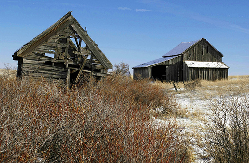
Preservation efforts in Hardman are grassroots and modest, led by the Hardman Historical Society and Association, which organizes monthly potluck dinners to foster community ties among the sparse residents. State support has funded renovations to the town hall (around $60,000 invested), now used for hunter's breakfasts during fall seasons, and the community center, which hosts occasional events. The standout landmark is the Hardman IOOF Lodge Hall, a two-story wooden edifice built in 1900 as a fraternal meeting space and store; added to the National Register of Historic Places in 2012, it stands as the last major commercial survivor, its facade a testament to the town's fraternal spirit. Other remnants include the old schoolhouse (recently reported destroyed by a controlled burn by the U.S. Forest Service in early 2025 to mitigate wildfire risks, sparking local nostalgia on social media), scattered clapboard homes (some restored, others sagging with age), a community hall, fallen barns, and rusted vehicles dotting the fields. The cemetery, with weathered headstones from pioneer families, adds a somber layer. As of September 2025, Hardman maintains a peaceful, eerie vibe—peaceful for its residents, eerie for visitors—with no formal museum but ample photo ops amid the golden grasslands. The dry climate has slowed decay, though wind and isolation pose ongoing threats.
Hardman occupies a verdant pocket of the Morrow County uplands, where
undulating wheat fields and bunchgrass prairies stretch toward the Blue
Mountains' eastern foothills, bisected by Rock Creek—a Columbia River
tributary that winds northwest through town, supporting riparian
cottonwoods and irrigation for remnant farms. The semi-arid continental
climate defines the area: hot, dry summers with highs of 85-95°F
(29-35°C) from June to August, punctuated by occasional thunderstorms;
crisp falls with harvest hues; and cold, snowy winters dipping to
15-30°F (-9 to -1°C) from December to February, with about 12-15 inches
(300-380 mm) of annual precipitation, mostly as winter rain or snow.
Windswept and remote, the landscape teems with wildlife like mule deer,
coyotes, and hawks, evoking the isolation that both sustained and doomed
the town.
Access is straightforward via paved OR-207 from Heppner (a
30-minute drive) or south from I-84, with gravel side roads leading into
the townsite—no high-clearance needed, but watch for potholes after
rain.
Hardman welcomes respectful day-trippers year-round, with no entrance
fees or hours—dawn to dusk is ideal for self-guided wanders along the
0.5-mile main drag, peering into the IOOF hall (exterior only), the
community hall, and overgrown lots where stores once stood. Start at the
town hall for a sense of lingering community, then stroll to the
cemetery for pioneer graves. Spring (April-May) brings wildflowers and
milder temps (50-70°F/10-21°C), while fall (September-October) offers
golden wheat vistas and fewer bugs. Summers can scorch, so visit early;
winters suit snowshoers but roads may ice over.
Pack essentials:
water, snacks, camera, and binoculars for birding—no services here, so
fuel up in Heppner (groceries, gas) or Spray (camping nearby at BLM
sites). Respect private property—much is owned by locals or absentees;
look but don't touch or enter buildings without permission, as artifacts
belong to residents. Cell service is spotty; download offline maps.
Combine with a road trip to nearby ghost towns like Lonerock (10 miles
south) or the John Day Fossil Beds (an hour west) for a full Eastern
Oregon adventure. For immersion, time your visit for hunting season
(October-November) to catch the town hall's breakfast buzz. Hardman
isn't a polished attraction but a living echo of frontier grit—approach
with curiosity, and let the whispering winds tell tales of dreams
deferred in the high desert.