Location: 2295 Purisima Road, Lompoc, Santa Barbara County, CA
Found: December 8, 1787
Official site
La Purísima Mission State Historic Park, located in the Santa Maria Valley of southern San Luis Obispo County, California, stands as one of the most complete and authentically reconstructed Spanish colonial missions in the state, offering a vivid portal to the early 19th-century Franciscan era of Alta California. Officially known as Mission La Purísima Concepción de Acuña (Mission of the Immaculate Conception), it was the eleventh of the 21 California missions founded by Franciscan friars under the direction of Father Fermín Lasuén. Situated approximately 20 miles northeast of Lompoc and 3 miles east of U.S. Route 101 (Exit 189), at coordinates 34°40′20″N 120°25′30″W and an elevation of about 300 feet (91 meters), the 2,230-acre park encompasses the original 1812 mission complex rebuilt after a devastating 1812 earthquake. Founded on December 8, 1787, the mission served as a hub for Chumash Neophyte labor, agriculture, and religious conversion until the Mexican secularization in the 1830s. Today, managed by California State Parks since its designation as a state historic park in 1934, La Purísima is a living museum with over 20 restored adobe and stone buildings, including living quarters, workshops, and a church, where costumed docents and living history programs immerse visitors in the daily life of missionaries and indigenous people.
La Purísima Mission's story is emblematic of the Spanish colonial
project in Alta California, blending religious zeal, forced labor, and
cultural upheaval during the mission period (1769-1836). The mission was
established on December 8, 1787—the Feast of the Immaculate
Conception—by Father Fermín de Lasuén, successor to Father Junípero
Serra, as part of Spain's effort to Christianize indigenous populations,
secure the frontier against Russian and British incursions, and develop
a self-sustaining economy. Initially sited at what is now Lompoc, the
mission was relocated 18 miles northeast in 1790 to fertile plains near
the Sisquoc River, better suited for agriculture and grazing, away from
the coastal fog and closer to reliable water sources. The new location,
on the traditional lands of the Qúupum (a Chumash subgroup), quickly
grew into a thriving outpost.
By the early 1800s, under the
leadership of Father Mariano Payers (1800-1824), La Purísima reached its
zenith, with a peak Neophyte population of around 1,000 Chumash converts
by 1804—drawn from local villages like those along the Santa Ynez River.
The mission's economy was robust: vast herds of cattle (over 10,000 by
1810), sheep, horses, and mules supported leather goods production (for
saddles and hides exported to Mexico); extensive vineyards and orchards
yielded wine, olives, and grains; and craft workshops produced textiles,
soap, and tools. The Chumash, relocated from their coastal villages,
provided the labor, often under coercive conditions that led to high
mortality from European diseases (smallpox, syphilis) and
overwork—estimates suggest a 90% population decline from 10,000 to 1,000
between 1770 and 1820. Religiously, the friars enforced baptism,
marriage, and communal living, suppressing Chumash traditions while
incorporating some elements, like using local materials in construction.
Tensions boiled over in the Chumash Revolt of 1824, a watershed event
sparked by a measles epidemic and harsh punishments. On December 16,
1824, Neophytes at La Purísima rose up, expelling the friars and
soldiers, killing 10, and holding the mission for four months—the
longest occupation of any California mission. The revolt spread to
nearby missions like Santa Inés and Santa Barbara, involving up to 5,000
Chumash. Mexican troops quelled it by June 1825, but the event
highlighted indigenous resistance and accelerated the missions' decline.
Secularization under Mexican rule in 1834 dissolved the missions,
redistributing lands to ranchos; La Purísima's 300,000 acres were
granted as the Nojoqui Rancho in 1835. By 1845, the site was in ruins,
used sporadically as a ranch headquarters.
The mission's revival
began in the early 20th century amid California's romanticized mission
revival architecture trend. In 1933, the Historical Landmark Advisory
Committee advocated for reconstruction, funded by the Civilian
Conservation Corps (CCC) and Works Progress Administration (WPA) during
the Great Depression. By 1938, the adobe complex was meticulously
rebuilt using original plans and archaeological evidence, becoming
California's first state historic park in 1934. During World War II, the
U.S. Army used it as a training base, but post-war, it focused on
preservation. In 1970, it was designated a National Historic Landmark,
underscoring its architectural and cultural value.
The mission's defining catastrophe was the massive La Purísima Earthquake of December 21, 1812—estimated at 7.1-7.5 magnitude on the Richter scale, with its epicenter near the mission. This event, part of the San Andreas Fault's activity, devastated the structures: the church collapsed, walls crumbled, and the quadrangle was severely damaged, forcing evacuation to a temporary site 5 miles south (now near present-day Mission La Purísima). Father Payers and the Neophytes rebuilt over the next decade, incorporating stone foundations and thicker adobe walls for seismic resilience, but the quake symbolized the fragility of the mission system. Modern reconstructions faithfully replicate this post-earthquake design, using traditional lime plaster and wooden vigas, making La Purísima a unique study in earthquake-resistant colonial architecture.
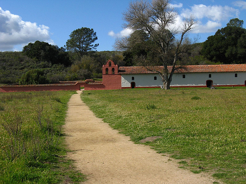
La Purísima's layout follows the classic California mission
quadrangle design: a central open courtyard (plaza) surrounded by
arcaded wings housing living and work spaces. The 2-acre core includes
22 buildings, rebuilt to 1818 specifications:
Church (Iglesia): A
long, narrow adobe structure with a wooden altar, confessional, and
baptismal font; its 30-foot bell tower houses three bells cast in
Mexico.
Monks' Quarters (Convento): A two-story dormitory with cells,
a library, and a sala for friars; now exhibits on mission life.
Neophyte Dormitories: Separate men's and women's barracks, reflecting
gender segregation; women's quarters include weaving rooms.
Workshops: Tannery, blacksmith forge, carpenter shop, and granary,
demonstrating self-sufficiency; the winery and distillery produced
sacramental wine.
Outbuildings: Soldier barracks, stables for 500
horses, and a cemetery with unmarked Chumash graves.
Irrigation
System: A 3-mile acequia (ditch) from the Sisquoc River, with aqueducts
and reservoirs, irrigated 6,000 acres—still visible today.
The
adobe bricks, made from local clay, and tile roofs exemplify
Spanish-Mexican vernacular style, adapted to the Chumash landscape with
native oaks and sycamores shading the grounds.
Post-secularization, the mission's lands were auctioned, and buildings fell into disrepair: roofs caved, walls eroded, and the site became a sheep ranch under owners like John Wick. By the 1880s, only ruins remained, scavenged for materials. The 1906 San Francisco earthquake indirectly aided preservation by heightening interest in seismic history, but it was the 1930s New Deal programs that saved it from oblivion.
Today, La Purísima is a premier living history site, with 80% of structures habitable and furnished with period artifacts: looms, plows, and religious icons. California State Parks maintains it through archaeological digs (e.g., 2023 Chumash artifact recovery) and Chumash consultations, emphasizing indigenous narratives. As of September 2025, the park is open and vibrant, with no major incidents; a summer 2025 wildland fire (contained 5 miles away) underscored drought risks, but irrigation upgrades protect the grounds. Living history weekends feature docents in period attire demonstrating crafts, and a new 2025 exhibit on the Chumash Revolt highlights resistance. The park hosts 100,000 visitors yearly, with revenue supporting restoration—recently, the tannery roof was replaced for $150,000.
Nestled in the Santa Maria Valley—a transitional zone between coastal fog and inland valleys—the park's 2,230 acres include grasslands, riparian woodlands along the Sisquoc River, and oak savannas supporting wildlife like red-tailed hawks, coyotes, and endangered steelhead trout. The Mediterranean climate features mild, wet winters (50-65°F/10-18°C, 15-20 inches rain) and warm, dry summers (70-85°F/21-29°C), ideal for the original agriculture but prone to wildfires and erosion. The valley's fertile alluvial soils, once mission fields, now border vineyards and farms.
Access via Highway 166 from U.S. 101 (30 minutes from Santa Maria; 1.5 hours from San Luis Obispo). Open daily 6 a.m.-6 p.m. (summer); 8 a.m.-5 p.m. (winter); closed Thanksgiving, Christmas. Entrance: $10/vehicle ($9 seniors); free for under 17. Self-guided tours via a 1.5-mile loop trail (1-2 hours) with audio wands ($5); guided tours ($7, weekends) and living history demos (free, seasonal). The visitor center offers exhibits, a film, and a gift shop with Chumash crafts. Picnicking in shaded groves; no camping on-site, but nearby Lopez Lake Recreation Area. Best in spring (April-May) for wildflowers or fall (September-October) for mild weather and grape harvest views. Pack water, sunscreen, and comfortable shoes—trails are flat but dusty. Accessibility includes wheelchair paths to key buildings. Respect cultural sensitivity: no touching artifacts, and learn about Chumash perspectives via the park's app. Combine with visits to nearby Nojoqui Falls or Solvang's Danish charm. As a 2025 visitor shared, it's a "peaceful dive into California's soul"—arrive early to wander the quiet quadrangle, where the mission's echoes of faith, labor, and rebellion linger in the valley breeze.