Location: Big Horn County, Montana Map
Area: 765 acres (3.0972 km2)
Commemorates: Little Bighorn Battlefield (June 25- 26 1876)
Tel. +1 406 638-2621. Spring: 8AM-6PM; Summer: 8AM-8PM; Fall: 8AM-6PM; Winter: 8AM-4:30PM. Private vehicle $20; Motorcycle $15; Walk/ bicycle $10/person.
Little Bighorn Battlefield National Monument, located in southeastern Montana near Crow Agency in Big Horn County, is a hallowed site preserving the memory of one of the most iconic and controversial clashes in American history: the Battle of the Little Bighorn, fought on June 25-26, 1876. Often called "Custer's Last Stand," the battle saw the combined forces of the Lakota, Northern Cheyenne, and Arapaho decisively defeat the 7th U.S. Cavalry Regiment under Lieutenant Colonel George Armstrong Custer, marking a pivotal moment in the Great Sioux War and the broader American Indian Wars. Situated along the Little Bighorn River at approximately 45°34′13″N 107°25′39″W and an elevation of 3,200 feet (975 meters), the 765-acre monument encompasses rolling grasslands, sagebrush hills, and the river’s cottonwood-lined banks, evoking the stark beauty of the Northern Plains. Managed by the National Park Service (NPS) since its designation as a national monument in 1946, the site honors all who fought and died—Native American warriors, U.S. soldiers, and civilians—through a balanced narrative that respects both perspectives.
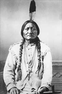
Sitting Bull (1831- 1890)
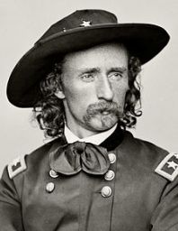
George Armstrong Custer (1839- 1876)
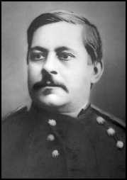
Marcus Reno (1834- 1889)
The Battle of the Little Bighorn was a flashpoint in the Great Sioux
War of 1876-1877, itself a chapter in the U.S. government’s campaign to
confine Plains tribes to reservations amid westward expansion. The
Lakota, Cheyenne, and Arapaho, led by figures like Sitting Bull
(Hunkpapa Lakota), Crazy Horse (Oglala Lakota), and Gall (Hunkpapa
Lakota), resisted relocation following the 1868 Treaty of Fort Laramie,
which guaranteed the Black Hills as part of the Great Sioux Reservation.
The discovery of gold in the Black Hills in 1874 sparked a rush of white
prospectors, violating the treaty and escalating tensions. By 1876, the
U.S. Army launched a campaign to force non-treaty bands onto
reservations, culminating in a three-pronged offensive targeting a
massive Native encampment along the Little Bighorn River.
On June 25,
1876, Custer’s 7th Cavalry—approximately 647 men, including 12
companies, scouts, and civilians—encountered an estimated 1,500-2,500
warriors from a village of 8,000-10,000 Lakota, Cheyenne, and Arapaho,
stretching 2 miles along the river. Underestimating the camp’s size and
cohesion, Custer divided his forces into three battalions, leading about
210 men himself to attack from the north. The battle unfolded in two
phases: Major Marcus Reno’s battalion faced fierce resistance in the
valley, retreating across the river with heavy losses, while Custer’s
detachment was overwhelmed on a ridge now called Last Stand Hill. Within
hours, Custer and his entire command were annihilated—268 soldiers and
civilians killed, including Custer, his brothers Tom and Boston, and
nephew Autie Reed. Native losses are estimated at 60-100 warriors,
though exact numbers remain uncertain due to oral traditions and
dispersed burials. The victory, while stunning, was pyrrhic: it
galvanized U.S. military retaliation, leading to the eventual surrender
of most bands by 1877 and Sitting Bull’s flight to Canada.
The
battle’s aftermath shaped national narratives. For whites, it was a
shocking defeat, mythologizing Custer as a tragic hero; for Native
Americans, it was a triumphant stand against encroachment, though
short-lived. The site, initially called Custer Battlefield National
Monument (designated in 1946), was renamed in 1991 to reflect a broader
perspective, acknowledging Native contributions and sacrifices.
The Battle of the Little Bighorn unfolded over two chaotic days, its
outcome shaped by terrain, tactics, and cultural resolve. On June 25,
Custer’s scouts, including Crow and Arikara allies, spotted the village
at dawn. Believing it smaller and fearing it would scatter, Custer
devised an aggressive plan: Reno would attack the southern end with
three companies (140 men), Captain Frederick Benteen would scout the
south with three (125 men), and Custer would strike from the north with
five (210 men), leaving one company to guard the pack train. The
village, however, was a coalition of seven bands—Hunkpapa, Oglala,
Miniconjou, Sans Arc, Blackfeet Lakota, Two Kettle, and Cheyenne—united
under Sitting Bull’s spiritual leadership, with warriors organized by
Crazy Horse and Gall.
Reno’s 11 a.m. charge into the valley met
overwhelming resistance from warriors under Gall, forcing a retreat to a
defensive bluff by 2 p.m., where survivors held out under siege.
Meanwhile, Custer’s battalion ascended Medicine Tail Coulee, likely
aiming to capture non-combatants to force surrender—a tactic used
previously. Instead, they encountered a massive counterattack led by
Crazy Horse, who outflanked Custer’s men, driving them to a series of
knolls culminating at Last Stand Hill. By 4:30 p.m., the warriors’
superior numbers, mobility (on horseback), and firepower (including
repeating rifles like Winchesters, alongside bows and lances)
overwhelmed Custer’s Springfield carbines, which jammed under rapid
fire. The final stand was brutal: archaeological evidence suggests a
rapid collapse, with soldiers pinned down in shallow rifle pits, some
committing suicide to avoid capture. By dusk, Custer’s command was
obliterated, bodies scattered across the ridge.
On June 26, the
Native forces maintained pressure on Reno and Benteen’s combined
survivors until withdrawing as General Alfred Terry’s relief column
approached. The warriors dismantled the village, scattering north to
evade pursuit. The battle shocked the nation, especially as news broke
during the U.S. Centennial celebrations, fueling calls for vengeance and
accelerating the reservation policy’s enforcement.
The site’s preservation began soon after the battle. In 1879, the U.S. Army established a national cemetery on the battlefield, reinterring soldiers’ remains on Last Stand Hill, marked by a mass grave and an 1881 granite obelisk listing the 7th Cavalry’s fallen. The area was designated a national cemetery in 1877 under the War Department, transferred to the NPS in 1940, and elevated to a national monument in 1946. The 1991 renaming to Little Bighorn Battlefield National Monument reflected a shift toward inclusivity, spurred by Native advocacy. In 1999, red granite markers were added for Native warriors, complementing the white marble markers for soldiers placed in 1890. The Indian Memorial, dedicated in 2003, features a circular plaza with a steel sculpture, “Spirit Warriors,” honoring Lakota, Cheyenne, and Arapaho losses. Ongoing tribal consultations, mandated by 2025 NPS policies, ensure Native voices shape interpretation, with Crow, Cheyenne, and Lakota representatives advising on exhibits and programs.
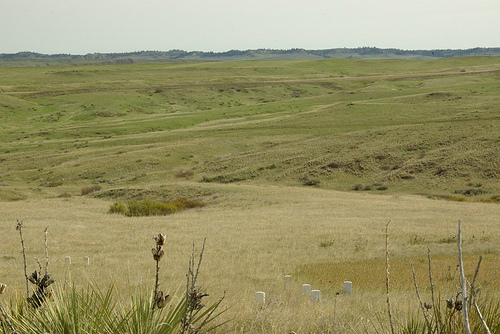
The monument spans 765 acres across two units: the Custer Battlefield
(Last Stand Hill and surrounding ridges) and the Reno-Benteen
Battlefield (4.5 miles southeast), connected by a scenic drive. The
Little Bighorn River winds through a shallow valley, flanked by grassy
bluffs, coulees, and cottonwood groves that provided tactical cover
during the battle. The terrain—rolling hills rising 300-400 feet above
the river—remains largely unchanged, preserving sightlines critical to
understanding the conflict. The region’s semi-arid Northern Plains
climate brings hot summers (highs 85-95°F/29-35°C June-August), crisp
falls with golden grasses, cold winters (lows 0-20°F/-18 to -7°C, 10-20
inches snow), and wet springs (12-15 inches annual precipitation).
Wildlife includes deer, pronghorn, and raptors, with the Crow
Reservation surrounding the site adding cultural context.
The visitor
center, near Last Stand Hill, houses a museum with artifacts (Custer’s
sword, Lakota quillwork, a Cheyenne war bonnet), a 15-minute orientation
film, and interactive maps. Self-guided trails include the 0.5-mile Deep
Ravine Trail and 1.5-mile Last Stand Hill loop, with ranger-led talks
(summer only) detailing key moments. The Indian Memorial and Custer
National Cemetery (closed to new burials) are focal points, with 249
soldier markers and 47 warrior markers scattered across the field. As of
2025, the site is fully operational, with virtual ranger programs added
for accessibility and no major incidents reported. Recent posts on X
praise the site’s “sobering beauty” and “balanced storytelling,” though
some note crowded summer tours.
Access is via I-90, exit 510 at Crow Agency, then a 1-mile drive to
the monument (756 Battlefield Tour Road). Open daily 8 a.m.-6 p.m.
(extended to 8 p.m. Memorial Day-Labor Day; 4:30 p.m. winter); closed
Thanksgiving, Christmas, New Year’s. Entrance fees are $25/vehicle,
$15/individual, or $80 for an America the Beautiful pass. Summer
(June-August) is peak, with ranger talks hourly 10 a.m.-4 p.m., but
spring/fall offer cooler temps (50-70°F/10-21°C) and fewer crowds. The
149th anniversary event (June 25-26, 2025) featured reenactments and
tribal ceremonies—check nps.gov/libi for 2026 plans. Pack water,
sunscreen, and sturdy shoes for uneven trails; the visitor center has
restrooms and a bookstore but no food—nearest dining in Hardin (15
miles). Respect sacred sites: no climbing markers, stay on paths, drones
prohibited. Cell service is reliable, but offline maps help. Combine
with visits to Pompeys Pillar or Bighorn Canyon for a regional tour.
Lodging options include Hardin motels or Billings (60 miles west);
camping at nearby KOA or 7th Ranch RV Park.
The monument is
wheelchair-accessible at the visitor center and Last Stand Hill
overlook, with audio tours for visually impaired visitors. For depth,
join the 1-hour bus tour ($10, summer only) or book a Crow-led
Apsáalooke Tour ($50, private) for tribal perspectives. As a September
2025 visitor noted, the site’s “silence speaks louder than the
battle”—approach with reverence for a place where history’s echoes of
courage and tragedy resonate across the windswept plains.