Location: Navajo & Coconino counties, AZ Map
Area: 360 acres (150 ha)
Tel. (928) 672- 2700
Open: 8am- 5pm daily
Closed: Jan 1, Thanksgiving, Dec 25
Official site
Navajo National Monument, located in northern Arizona within the Navajo Nation, is a 360-acre preserve that safeguards three of the best-preserved Ancestral Puebloan cliff dwellings in the Southwest: Betatakin, Keet Seel, and Inscription House. Situated in Navajo County near the Utah border, at coordinates approximately 36°40′42″N 110°32′39″W and an elevation of 7,300 feet (2,225 meters), the monument lies in the rugged Shonto Plateau, a high-desert landscape of piñon-juniper woodlands, red sandstone canyons, and sagebrush flats. Established on March 20, 1909, by President William Howard Taft, the monument is managed by the National Park Service (NPS) in partnership with the Navajo Nation, balancing cultural preservation with limited public access to protect these sacred sites. The dwellings, built by the Kayenta Anasazi between 1250 and 1300 CE, offer a window into a sophisticated prehistoric culture that thrived before mysteriously abandoning the area. As of September 2025, the monument remains a serene, under-visited gem, drawing about 40,000 visitors annually for its hiking trails, guided tours, and cultural significance to the Navajo (Diné), who consider the sites ancestral and spiritually vital. Recent updates include enhanced virtual tours and stricter trail regulations to curb erosion, reflecting ongoing efforts to honor the land’s heritage amid climate challenges.
The history of Navajo National Monument is deeply tied to the
Ancestral Puebloans, also known as the Anasazi, a prehistoric culture
that flourished in the Four Corners region from roughly 100 BCE to 1300
CE. The monument’s three cliff dwellings—Betatakin (Talastima, “place of
the corn tassel” in Navajo), Keet Seel (Kitsʼiilí, “broken pottery”),
and Inscription House (Tsééʼąąʼí Níłchʼąąʼí, “house with writings”)—were
constructed during the Pueblo III period (1150-1300 CE) by the Kayenta
branch of the Anasazi, a subgroup known for advanced masonry and
adaptation to arid environments. These cliff villages, tucked into
natural alcoves, housed 100-150 people each, supported by dryland
farming of corn, beans, and squash, supplemented by hunting and
gathering. The dwellings’ strategic locations offered defense, shade,
and access to springs, reflecting a sophisticated understanding of the
landscape.
By 1300 CE, the inhabitants abandoned the sites, likely
due to prolonged drought, resource depletion, or social pressures, as
evidenced by tree-ring data (dendrochronology) showing severe aridity in
the late 13th century. The Navajo, arriving in the region around the
15th century, reoccupied the area, weaving the dwellings into their oral
traditions as ancestral homes of the Anasazi, whom they call Anáásází
(“ancient ones”). The sites remained largely unknown to outsiders until
the late 19th century, when explorers like John Wetherill and Byron
Cummings rediscovered them. Wetherill, a trader and guide, led
expeditions to Betatakin in 1909, prompting Taft’s proclamation to
protect the sites from looting, a rampant issue following the 1906
Antiquities Act.
The monument’s establishment marked an early victory
for preservation, though early management focused on archaeological
study over Indigenous perspectives. Since the 1990s, NPS collaboration
with the Navajo Nation has shifted toward co-stewardship, with Diné
guides and elders shaping interpretation to emphasize cultural
continuity. Inscription House, damaged by vandalism, has been closed to
the public since 1968, but Betatakin and Keet Seel offer limited tours,
balancing access with protection. Recent 2025 initiatives include
virtual reality exhibits at the visitor center and Navajo-led cultural
programs, reinforcing the monument’s role as a living heritage site.
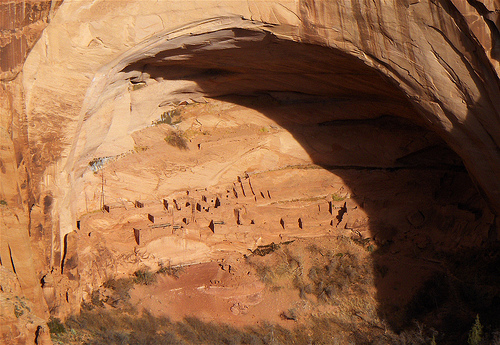
Betatakin (Talastima):
Description: The most accessible dwelling,
Betatakin occupies a 450-foot-wide alcove in Tsegi Canyon, housing about
100 residents in 1250-1286 CE. Its 135 rooms include living quarters,
kivas (ceremonial chambers), and granaries, built with sandstone blocks,
mud mortar, and juniper beams. The alcove’s overhang preserved intricate
masonry, with some walls standing 20 feet high.
Significance:
Betatakin’s name reflects its agricultural role, with nearby springs and
fields supporting maize. Tree-ring dating confirms construction over a
single generation, suggesting rapid building during a stable climate
window.
Access: A 5-mile round-trip guided hike (3-5 hours,
May-September) descends 700 feet into the canyon. Limited to 25
people/day, first-come, first-served at the visitor center ($20/adult,
2025 rate).
Keet Seel (Kitsʼiilí):
Description: The largest
and best-preserved dwelling, Keet Seel spans a 400-foot alcove with
150-160 rooms, including 6 kivas, housing up to 150 people from
1272-1295 CE. Its remote location in Keet Seel Canyon protected it from
looting, preserving artifacts like pottery, textiles, and corncobs.
Significance: The site’s scale and preservation make it a premier
archaeological treasure, with original roof beams and plaster intact.
Its name, “broken pottery,” reflects abundant sherds found by early
explorers.
Access: An arduous 17-mile round-trip hike (8-12 hours,
Memorial Day-Labor Day) requires a permit ($10/person, 20 hikers/day).
Backpacking options (overnight, $15) involve camping near the site;
guided tours only.
Inscription House:
Description: The
smallest dwelling, with 74 rooms in Nitsin Canyon, built around 1270 CE.
Named for a 19th-century inscription (possibly Spanish or Anglo
graffiti), it housed about 75 people.
Significance: Less studied due
to structural instability, it mirrors Betatakin’s design but is closed
to protect fragile masonry.
Access: Off-limits since 1968; viewable
only via NPS archives or virtual tours.
Navajo National Monument occupies the Shonto Plateau, a
high-elevation extension of the Colorado Plateau, characterized by deep,
red-walled canyons (Tsegi, Keet Seel, Nitsin) carved by seasonal streams
into Navajo Sandstone and Kayenta Formation layers. The landscape is a
mosaic of piñon pines, junipers, sagebrush, and yucca, with panoramic
views of Black Mesa and distant Kaibab Plateau. Wildlife includes
coyotes, bobcats, mule deer, and raptors, with sacred springs like
Betatakin’s supporting cottonwoods and willows.
The semi-arid climate
is harsh: hot summers (highs 85-95°F/29-35°C June-August) with monsoonal
rains (flash flood risks); mild springs/falls (50-75°F/10-24°C, ideal
for hiking); and cold winters (lows 15-30°F/-9 to -1°C) with 10-15
inches of snow. Annual precipitation averages 10-12 inches, preserving
wood and adobe but eroding trails. As of September 2025, the monument is
fully operational, with no closures reported. Recent upgrades include
solar-powered visitor center displays and a 2025 NPS trail maintenance
project to stabilize canyon paths. Visitor posts on X praise the
“spiritual stillness” and “epic hikes,” though some note limited tour
slots. Drought (ongoing since 2020) stresses local water sources,
prompting Navajo-led conservation efforts.
The monument is a sacred space for the Navajo, who trace ancestral ties to the Anasazi and use the canyons for ceremonies. The NPS collaborates with Diné elders to protect cultural resources, restricting access to unexcavated sites and prohibiting artifact removal. The 2025 Navajo Nation Cultural Preservation Plan emphasizes oral history integration, with guides sharing stories of the Holy People and clan migrations. Tourism (40,000 visitors/year, down from 100,000 pre-COVID) supports the local economy, with 80% of staff being Navajo, but over-visitation risks trail erosion and alcove damage. Environmental challenges include drought (2025 precipitation 30% below average), invasive cheatgrass, and wildfire risks, mitigated by NPS firebreaks and native plant restoration.
Access: From Kayenta, AZ (20 miles east), take US-160 west to AZ-564
north (9 miles) to the visitor center. Nearest airports are Flagstaff
(150 miles) or Page (90 miles). Open daily 8 a.m.-5 p.m. (summer); 9
a.m.-4:30 p.m. (winter); closed Thanksgiving, Christmas, New Year’s.
Fees: Free entry; guided tour fees ($10-$20) support maintenance.
Trails: Three self-guided trails (0.4-1 mile) near the visitor
center—Sandal Trail (1 mile, Betatakin overlook), Aspen Trail (0.8 mile,
forest views), Canyon View Trail (0.4 mile)—are easy and open
year-round. Guided hikes to Betatakin (daily, May-September) and Keet
Seel (weekends, June-August) require reservations at the visitor center
or recreation.gov (book 3-6 months ahead). Gear: Bring 1 gal
water/hiker, sunscreen, sturdy boots (canyon trails are rocky), and
layers for altitude swings. No pets on guided hikes; leashed pets OK on
rim trails. Rules: Stay on paths, no touching ruins, drones prohibited,
respect Navajo protocols (no photography in sacred areas without
permission). Facilities: Visitor center has restrooms, exhibits
(pottery, tools), and a gift shop with Navajo crafts; no food/water
on-site—stock up in Kayenta. Lodging/Camping: Free campgrounds (Sunset
View, 31 sites; Canyon View, 16 sites; first-come, first-served; no
hookups) close November-March. Nearest hotels in Kayenta (Hampton Inn,
$100-$200). Combine With: Monument Valley (30 miles east), Canyon de
Chelly (60 miles southeast), or Antelope Canyon (90 miles west).
Best
Times: April-May or September-October for mild weather
(60-80°F/16-27°C), vibrant wildflowers, and fewer crowds. Summer hikes
demand early starts to avoid heat; winter offers solitude but snow may
close trails. Tips: Arrive by 8 a.m. for Betatakin tour spots; Keet Seel
requires fitness and preparation (carry 2L water, expect no facilities).
Virtual tours on nps.gov/nava suit remote explorers. As a 2025 visitor
noted on X, “The canyons feel alive with history.” Approach with
reverence—Navajo National Monument is a sacred window into the past,
where the Anasazi’s stone whispers endure under Diné skies.