Location: Bellingham Map
Area: 684,000 acres (1,069 sq mi)
Official site
North Cascades National Park information center:
Tel: (360) 873 4500x39
When to come:
late July to October
Backcountry permit: required, free permit issued at Marblemount
North Cascades National Park, located in northwestern Washington, spans 504,781 acres across Whatcom, Skagit, and Chelan counties, encompassing some of the most rugged, glaciated, and biodiverse landscapes in the contiguous United States. Established on October 2, 1968, the park is part of the North Cascades National Park Service Complex, which includes Ross Lake and Lake Chelan National Recreation Areas, totaling 684,000 acres. Known as the “American Alps,” it features jagged peaks, over 300 glaciers, 400 miles of trails, and pristine rivers like the Skagit and Stehekin. With only 38,000 visitors annually (2023), it remains one of the least-visited national parks, offering solitude amid towering mountains, alpine meadows, and old-growth forests. Managed by the National Park Service (NPS), the park balances wilderness preservation with limited access, emphasizing its role as a haven for climbers, hikers, and wildlife like grizzly bears and gray wolves.
North Cascades National Park lies 100 miles northeast of Seattle, 50
miles east of Bellingham, and 40 miles south of the Canadian border,
abutting British Columbia’s Chilliwack Provincial Park. It spans the
Cascade Range’s northern section, a volcanic arc formed by the
subduction of the Juan de Fuca Plate. The park’s terrain is among the
most rugged in the Lower 48:
Peaks: Over 100 peaks exceed 8,000
feet, including Goode Mountain (9,206 feet), the park’s highest, and
Mount Shuksan (9,131 feet), a photographer’s icon. Boston Peak,
Forbidden Peak, and Eldorado Peak are climbing meccas.
Glaciers: 312
active glaciers, the most of any U.S. park outside Alaska, cover 38
square miles. Boston Glacier, at 7 square miles, is the largest. Glacial
cirques, like those below Sahale Peak, cradle tarns like Doubtful Lake.
Valleys: U-shaped valleys, carved by Pleistocene glaciers, include
Thunder Creek, Chilliwack River, and Stehekin Valley, with meadows and
wetlands hosting black bears and beavers.
Passes: Cascade Pass (5,392
feet) and Washington Pass (5,477 feet) offer panoramic views, accessed
via trails or State Route 20 (North Cascades Highway).
Elevations
range from 400 feet at Goodell Creek to 9,206 feet at Goode Mountain,
creating extreme vertical relief—up to 7,000 feet in 2 miles—rivaling
the Grand Canyon. The park covers 789 square miles, with 93% designated
wilderness since 1988, ensuring minimal development.
The North Cascades’ geology is a 400-million-year mosaic:
Pre-Cretaceous (400–90 million years ago): Metamorphic rocks (schist,
gneiss) and plutonic granites form the core, accreted as terranes
collided with North America. The Skagit Gneiss, 200 million years old,
is prominent in Diablo Lake.
Cretaceous-Tertiary (90–40 million years
ago): Intrusive granites, like the Golden Horn Batholith, formed peaks
like Liberty Bell. Volcanic ash and lava, now eroded, capped older
rocks.
Cenozoic (40 million years ago–present): Uplift from
subduction raised the Cascades, with peaks sharpened by erosion. The
Chilliwack Group’s marine fossils (limestone) hint at ancient seas.
Pleistocene Glaciation (2 million–10,000 years ago): Glaciers carved
fjord-like valleys, arêtes (Knife Edge), and horns (Bear Mountain).
Moraines and erratics dot Ross Lake.
Current glaciation, though
retreating (20% volume loss since 1980), shapes the landscape, with
crevasses and seracs on Lower Curtis Glacier. The park’s faults, like
the Ross Lake Fault, are active, with minor quakes recorded.
Water is the park’s lifeblood:
Rivers: The Skagit River,
draining west to Puget Sound, is Washington’s second-largest, with 150
miles of wild and scenic segments. The Stehekin River, fed by McAlester
Creek, joins Lake Chelan. Thunder Creek and Chilliwack River carve
turquoise channels.
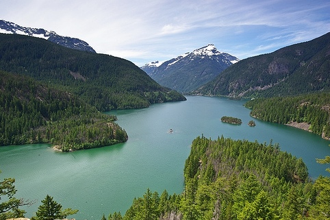
Lakes: 240+ lakes, from alpine tarns (Sahale Arm)
to large reservoirs like Diablo Lake, dammed for Seattle’s power. Ross
Lake (23 miles long, partly in Canada) and Lake Chelan (50 miles) are in
adjacent recreation areas but integral to the complex.
Waterfalls:
Over 100 falls, including Gorge Falls (242 feet, accessible via SR-20)
and Rainbow Falls (312 feet, near Stehekin). Ladder Creek Falls, lit at
night, is a Newhalem highlight.
Glacial Runoff: Snowmelt and glacial
silt give Diablo Lake its emerald hue, peaking in June–July.
Annual
precipitation varies: 80 inches in western valleys, 200 inches as snow
on peaks. The Skagit’s dams (Gorge, Diablo, Ross), built 1918–1960,
generate 20% of Seattle’s electricity but alter fish runs, with NPS
mitigation ongoing.
The park’s maritime-influenced, cold, wet climate (Köppen Dfb)
reflects its Cascade position:
Temperature: Summer highs average
70°F (July) at 1,000 feet, 50°F at 6,000 feet. Winter lows reach 20°F
(January) in valleys, -10°F on peaks. Glacial areas stay below 40°F
year-round.
Precipitation: Annual rainfall is 40–80 inches in
valleys, with 100–200 inches of snow above 4,000 feet. Western slopes
are wetter (orographic lift), eastern slopes drier. November–March
brings 80% of moisture.
Winds: Pacific storms deliver 30–50 mph
gusts, with avalanches common in winter.
Seasons: Spring (May–June)
is muddy with snowmelt; summer (July–August) is prime hiking; fall
(September–October) offers larch gold and clear skies; winter
(November–April) is snowy, ideal for skiing but with road closures.
Climate change accelerates glacial retreat (50% area loss since 1900)
and shifts fire regimes, with the 2015 Goodell Fire burning 8,000 acres.
NPS monitors snowpack, down 25% since 1980.
The park’s elevation range (400–9,206 feet) creates four ecological
zones:
Lowland Forest (400–2,000 feet, Newhalem): Old-growth
western redcedar, Douglas fir, and hemlock, some 800 years old, host
black bears, river otters, and spotted owls. Ferns and mosses thrive in
shade.
Montane Forest (2,000–4,000 feet, Cascade Pass): Ponderosa
pine, lodgepole pine, and maple support mule deer, mountain goats, and
woodpeckers. Huckleberries feed grizzlies.
Subalpine (4,000–6,500
feet, Sahale Arm): Subalpine fir, mountain hemlock, and meadows with
paintbrush and lupine host marmots, pikas, and gray jays. Golden larches
blaze in fall.
Alpine (6,500–9,206 feet, Boston Glacier): Tundra-like
heather, sedges, and lichens survive wind and snow. Mountain goats,
ptarmigan, and rare wolverines roam.
The park supports 75 mammal
species, 200 birds, 17 reptiles/amphibians, and 1,600+ plants, including
20 endemics like the North Cascades monkeyflower. Reintroduced grizzly
bears (10–20 estimated) and gray wolves (5–10) are recovering, with
fisher reintroductions since 2018. Threats include invasive Himalayan
blackberry and fire-driven habitat shifts, with NPS removing 200 acres
of invasives annually.
Paleo-Indians hunted in the Cascades 10,000 years ago, leaving tools near Skagit River. By 5000 BCE, Coast Salish (Skagit, Sauk-Suiattle) and Interior Salish (Nlaka’pamux, Okanagan) tribes used the region, fishing salmon, hunting goats, and gathering camas. Trails over Cascade Pass linked Puget Sound to eastern Washington, with trade in obsidian and shells. The Skagit’s name, meaning “swift waters” in Lushootseed, reflects cultural ties. By 1800, smallpox from European contact decimated tribes, reducing Upper Skagit populations by 50%.
Fur traders, like Alexander Ross (1814), crossed the Cascades,
followed by U.S. Army surveys in the 1850s seeking railroad routes. The
1855 Point Elliott Treaty confined Skagit tribes to reservations,
opening the area to miners during the 1858 Fraser Gold Rush. Prospectors
found placer gold in Ruby Creek, but yields were low, limiting
settlement. In 1888, the Skagit River’s hydropower potential drew
engineers, with Newhalem founded as a logging camp.
Homesteaders,
like Lucinda Davis in Stehekin (1880s), farmed and mined, with 50
residents by 1900. The rugged terrain deterred large-scale settlement,
preserving wilderness. The 1897 Mountaineers Club began recreational
climbing, with early ascents of Mount Shuksan.
The early 20th century saw conservation efforts. In 1899, the North
Cascades were included in the Washington Forest Reserve, precursor to
the Okanogan-Wenatchee National Forest. Loggers and miners opposed
protection, but naturalists like John Muir and the Sierra Club, inspired
by 1906 visits, advocated for a park. The 1916 NPS formation intensified
calls, with the 1937 North Cascades Study Report recommending national
park status.
World War II delayed action, but post-war recreation
boomed, with climbers like Fred Beckey pioneering routes on Forbidden
Peak. The 1963 Leopold Report, emphasizing ecological preservation,
bolstered support. In 1968, President Lyndon B. Johnson signed the North
Cascades National Park Act, creating the park and recreation areas to
balance wilderness (504,781 acres) with access (Ross Lake, Lake Chelan).
The Stephen Mather Wilderness, designated in 1988, covers 93% of the
park.
The park developed minimal infrastructure to preserve wilderness:
1970s–1980s: Trails like Cascade Pass and campgrounds at Colonial
Creek were built. SR-20, completed in 1972, became the park’s main
artery.
1990s–2000s: Grizzly recovery plans and tribal consultation
with the Skagit Tribe grew. The 2006 Skagit River General Management
Plan limited development.
2010s–Present: The 2015 Goodell Fire and
2021 Diablo Fire (10,000 acres) prompted reforestation. Visitation rose
from 20,000 (2000) to 38,000 (2023), with backcountry permits capping
crowds.
Tribal partnerships, formalized in 2019, integrate Salish
knowledge into exhibits. Climate-driven glacial loss (30% since 1980)
and wildfire risks challenge management, with NPS planting 50,000 trees
since 2016.
Native Stewardship: Salish trails and fisheries shaped the Cascades,
with modern co-management restoring cultural ties.
Wilderness Ethos:
The park’s 1968 creation, amid 1960s environmentalism, prioritized
pristine ecosystems, influencing parks like Gates of the Arctic.
Climbing Legacy: Routes by Beckey and others made the Cascades a global
climbing hub, with 80% of peaks requiring technical skills.
Hydropower Tension: Skagit dams highlight trade-offs between energy and
ecology, with NPS advocating for fish passage.
Scenic Drives: SR-20 (North Cascades Highway, 120 miles) offers
Diablo Lake Overlook and Washington Pass, open May–November. Stehekin
Valley Road (13 miles, shuttle-only) accesses Rainbow Falls.
Hiking:
400 miles of trails, from easy (0.5-mile Happy Creek) to strenuous
(35-mile Copper Ridge Loop). Cascade Pass (7.4 miles) and Thornton Lakes
(10 miles) are highlights.
Climbing: Technical routes on Bear
Mountain (5.10) and Goode (IV 5.9) require permits ($20). Eldorado
Peak’s knife-edge is iconic.
Boating/Fishing: Kayaking on Ross Lake
and trout fishing in Thunder Creek (catch-and-release). Boat rentals in
Stehekin ($50/hour).
Wildlife Viewing: Grizzlies near Cascade Pass,
mountain goats on Sahale Arm, and bald eagles along the Skagit.
Binoculars essential.
Camping: Colonial Creek (130 sites, $24/night)
and Goodell Creek (21 sites, $20) require reservations (recreation.gov).
Backcountry permits ($20/trip) cap wilderness use.
Winter:
Cross-country skiing and snowshoeing near SR-20’s closure points, with
avalanche gear required.
The park is open 24/7, with peak visitation
in summer (July–August, 60–70°F). Fall (September) offers larch
displays; winter (November–April) closes SR-20 but opens ski routes.
Spring (May–June) is wet but lush. Entry is free, but recreation areas
charge $5/day.
By Car: From Seattle (120 miles, 2.5 hours), take I-5 north to SR-20
east (Marblemount entrance). From Spokane (280 miles, 5 hours), take
U.S. 2 to SR-20 west. SR-20 closes November–April; Stehekin is boat or
hike-in only (via Lake Chelan).
Public Transit: None to the park.
Amtrak to Mount Vernon (60 miles) requires car rental. Seattle’s SeaTac
Airport (130 miles) offers shuttles ($150–$250).
Facilities:
Marblemount Ranger Station and Newhalem Visitor Center (open summer, 9
a.m.–5 p.m.) provide maps. Stehekin’s Golden West Visitor Center serves
boat arrivals. No lodging or food in the park; Marblemount (motels,
$100–$200) and Stehekin (North Cascades Lodge, $150–$300) offer options.
Gas is unavailable inside; fill up in Marblemount or Winthrop.
Trails
and Roads: 10% of trails are ADA-accessible (e.g., Sterling Munro).
Backcountry routes like Chilliwack River require fording.
Low Visitation: 38,000 visitors (2023, 1% of Yellowstone’s) preserves
solitude but limits funding, with NPS relying on volunteers (500/year).
Glacial Retreat: 30% ice loss since 1980 threatens water flows; NPS
monitors 50 glaciers annually.
Wildfires: 15% of the park burned
since 2000, with reforestation ongoing. The 2021 Diablo Fire closed
SR-20 for weeks.
Wildlife Recovery: Grizzly and wolf reintroductions
face rancher opposition; NPS plans 3–7 grizzly releases annually through
2030.
Invasives: Knotweed and blackberry spread along rivers; NPS
removes 100 acres yearly.
The 1988 Wilderness Act and 2010 General
Management Plan prioritize minimal impact, with 93% of the park
roadless. Tribal co-stewardship with the Skagit Tribe restores salmon
and cultural sites.
Timing: Summer is best for trails; reserve backcountry permits 6
months ahead (nps.gov/noca). Fall larches peak mid-September; winter
requires avalanche training. Allow 3–5 days for hikes, climbs, and
boating.
Preparation: Bring layers for 20–40°F swings, 4 liters
water/hiker, and bear spray ($40). Download NPS app; cell service is
absent. Ice axes and crampons needed for climbs.
Safety: Altitude
(4,000–9,000 feet) risks sickness; descend if dizzy. Glacial crevasses
and river fords are hazardous. Bears require 100-yard distance; store
food in canisters.
Respect: Stay on trails to protect meadows
(recovery takes 50 years). No pets in backcountry. Pack out trash.
Nearby: Marblemount’s Buffalo Run Restaurant ($15–$30) and Winthrop’s
Old Schoolhouse Brewery. Mount Baker-Snoqualmie NF (30 miles) offers
skiing; Seattle (120 miles) has museums.
Events: Stehekin Heritage
Days (July) and Skagit Eagle Festival (January, nearby). Check
nps.gov/noca for ranger talks.