Location: Boulder, Grand, Larimer Counties, CO Map
Area: 265,761 acres (107,550 ha)
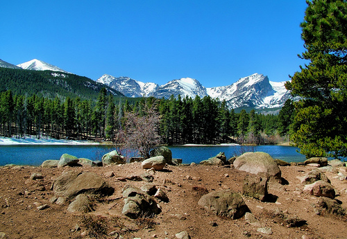
Rocky Mountain National Park, located in northern Colorado, spans 265,461 acres across Larimer, Grand, and Boulder counties, encompassing some of the most dramatic and pristine alpine landscapes in the United States. Established in 1915, the park is renowned for its rugged peaks, alpine tundra, glacier-carved valleys, and abundant wildlife, including elk, bighorn sheep, and marmots. Straddling the Continental Divide, it features over 300 miles of trails, 150 lakes, and peaks like Longs Peak (14,259 feet), drawing 4.4 million visitors annually (2023). Managed by the National Park Service (NPS), the park balances preservation with recreation, offering hiking, climbing, wildlife viewing, and scenic drives like Trail Ridge Road, the highest continuous paved road in North America.
Rocky Mountain National Park lies 70 miles northwest of Denver,
centered between the towns of Estes Park (east) and Grand Lake (west).
It spans the Rocky Mountains’ Front Range and Northern Rockies, with the
Continental Divide running north-south, separating Atlantic and Pacific
watersheds. The park’s terrain is defined by:
Peaks: 77 named
peaks over 12,000 feet, including Longs Peak (14,259 feet), the park’s
highest, and Bear Lake’s Hallett Peak (12,713 feet). The Mummy Range,
Never Summer Mountains, and Medicine Bow Mountains add diversity.
Valleys: Glacial valleys like Moraine Park, Horseshoe Park, and
Kawuneeche Valley host meadows and wetlands, ideal for elk grazing.
Alpine Tundra: Above 11,000 feet, 25% of the park is treeless tundra,
with fragile soils and dwarf plants, accessible via Trail Ridge Road
(12,183 feet max).
Cirques and Moraines: Glacier-carved features like
Dream Lake’s cirque and Moraine Park’s lateral moraines, formed 15,000
years ago, create dramatic vistas.
Elevations range from 7,630 feet
at Beaver Meadows to 14,259 feet at Longs Peak, creating stark
ecological gradients. The park covers 415 square miles, with 95%
designated wilderness since 2009, limiting development to protect its
pristine character.
The park’s geology reflects 1.8 billion years of Earth’s history:
Precambrian Basement (1.8–1.4 billion years ago): Gneiss and schist,
exposed in Longs Peak and Wild Basin, form the core of the Rockies,
uplifted during the Laramide Orogeny (70–40 million years ago).
Paleozoic-Mesozoic Sediments (500–65 million years ago): Limestone and
sandstone layers, eroded from most peaks but visible in lower valleys,
record ancient seas.
Cenozoic Volcanics (28 million years ago):
Intrusive granites and volcanic ash, like Specimen Mountain’s tuff, add
complexity.
Pleistocene Glaciation (2 million–10,000 years ago):
Glaciers carved U-shaped valleys, cirques, and tarns (e.g., Emerald
Lake), depositing moraines and polishing granite faces.
Erosion
continues, with the Cache la Poudre and Big Thompson Rivers shaping
valleys. The park’s faults, like the Glacier Creek Thrust, are inactive
but visible in deformed rocks near Bear Lake.
Water defines the park’s geography:
Rivers: The Colorado River
headwaters begin in the Never Summer Mountains, flowing west through
Kawuneeche Valley. The Cache la Poudre (north), Big Thompson (east), and
Fall River (east) drain to the Atlantic, carving canyons like Lumpy
Ridge.
Lakes: 150 named lakes, from alpine tarns (Sky Pond) to
moraine-dammed lakes (Bear Lake). Sprague Lake and Lake Irene are
accessible for fishing and kayaking.
Waterfalls: Over 30 named falls,
including Alberta Falls (0.6-mile hike) and Ouzel Falls (5.4 miles), fed
by snowmelt peaking in June.
Wetlands: Moraine Park and Kawuneeche
Valley’s marshes support moose and waterfowl, with beaver dams shaping
floodplains.
Annual snowmelt (100–150 inches at higher elevations)
feeds streams, while 30 inches of rainfall supports riparian zones. The
1913–1915 Grand Ditch, diverting water to Colorado’s Front Range,
remains controversial, with NPS restoration mitigating ecological
damage.
The park’s high-altitude climate is cold, semi-arid, and variable
(Köppen Dfc):
Temperature: Summer highs average 70–80°F (July) at
8,000 feet, dropping to 50°F at 12,000 feet. Winter lows reach -10°F
(January), with highs of 25–35°F. Alpine areas see 40°F swings daily.
Precipitation: Annual rainfall is 14–20 inches in valleys, 30 inches
above 10,000 feet. Snowfall averages 150 inches at Bear Lake, 300 inches
on peaks, with drifts closing Trail Ridge Road (November–May).
Winds:
Gusts of 60–100 mph on tundra, especially spring, erode soils and
challenge hikers.
Seasons: Spring (May–June) brings mud and
wildflowers; summer (July–August) is peak hiking season; fall
(September–October) offers elk rut and aspen colors; winter
(November–April) is ideal for snowshoeing but avalanche-prone.
Climate change reduces snowpack (20% less since 1980) and shifts elk
migrations, with NPS monitoring glacier remnants like Andrews Glacier.
The park’s elevation gradient (7,630–14,259 feet) creates four
ecological zones:
Montane (7,600–9,000 feet, Moraine Park):
Ponderosa pine, Douglas fir, and aspen groves support elk, mule deer,
and red-tailed hawks. Meadows host pasqueflower and columbine.
Subalpine (9,000–11,000 feet, Bear Lake): Engelmann spruce, subalpine
fir, and lodgepole pine dominate, with moose, mountain lions, and
Clark’s nutcrackers. Lakes support trout.
Alpine Tundra
(11,000–14,259 feet, Trail Ridge): Dwarf plants (alpine avens, phlox)
and lichens survive harsh winds. Pikas, marmots, and bighorn sheep
thrive, with ptarmigan camouflaged in snow.
Riparian: Cottonwoods and
willows along rivers host beavers, dippers, and 280 bird species,
including great blue herons.
The park supports 67 mammal species,
280 birds, 11 reptiles, 5 amphibians, and 1,000+ plants, including 30
endemics. Reintroduced species include bighorn sheep (200 in 2023) and
greenback cutthroat trout. Threats include invasive cheatgrass and pine
beetle outbreaks, killing 80% of lodgepole pines by 2010, with NPS
replanting efforts ongoing.
Prehistoric and Native American Presence (10,000 BCE–1800 CE)
Paleo-Indians hunted in the park 11,000 years ago, leaving Clovis points
in Moraine Park. Archaic peoples (6000 BCE–500 CE) used caves like
Oldman Mountain, while Ute and Arapaho bands arrived by 1000 CE, hunting
elk and summering in Kawuneeche Valley. Ute trails over Flattop Mountain
and Arapaho names like “Niwot” (Left Hand) persist. By 1800, smallpox
and settler encroachment reduced Native presence, with the 1864 Sand
Creek Massacre and 1878 Ute removal to Utah ending their seasonal use.
Exploration and Settlement (1800–1900)
Fur trappers, including
Rufus Sage (1840s), crossed the park, followed by the 1859 Colorado Gold
Rush, bringing prospectors to Estes Park. Joel Estes settled in 1860,
naming the valley, but harsh winters limited growth. In 1868, John
Wesley Powell explored the Grand Lake area, documenting peaks. The 1873
Hayden Survey mapped Longs Peak, sparking tourism.
Miners arrived
in the 1870s, targeting gold and silver in Lulu City and Gaskill, but
low yields led to abandonment by 1884. Homesteaders like Abner Sprague
(1875) farmed Moraine Park, later building lodges. The 1880
establishment of Larimer County and Estes Park’s growth as a resort town
set the stage for conservation.
Park Establishment (1900–1915)
The early 20th century saw calls to protect the Rockies. Enos Mills, a
naturalist and lodge owner, advocated for a park, inspired by John Muir.
His 1909 book, Wild Life on the Rockies, and lectures nationwide rallied
support. In 1910, the NPS was proposed, and Mills lobbied Congress,
overcoming opposition from miners and ranchers. On January 26, 1915,
President Woodrow Wilson signed the act creating Rocky Mountain National
Park, covering 229,062 acres (expanded to 265,461 by 1930).
Development and Modern Era (1915–Present)
The NPS developed
infrastructure:
1916–1930s: Trail Ridge Road (1932), Bear Lake
Road, and ranger stations, with Civilian Conservation Corps (CCC) trails
and campgrounds.
1940s–1960s: Post-World War II tourism surged, with
1 million visitors by 1960. The 1957 Mission 66 program added the Beaver
Meadows Visitor Center (Richard Neutra design).
1970s–2000s: The 1976
Wilderness Act proposed 95% of the park as wilderness, finalized in
2009. The 1982 Big Thompson Flood killed 8, prompting river restoration.
Visitation grew to 4.4 million in 2023, straining resources. The 2020
East Troublesome Fire, burning 21,000 park acres, highlighted climate
risks, with NPS replanting 1.5 million trees by 2023. Timed-entry
permits (2021–present) manage crowds, requiring reservations ($2,
May–October). Tribal partnerships with the Arapaho and Ute, formalized
in 2018, add Native perspectives to interpretation.
Native Legacy: Ute and Arapaho stewardship shaped trails and ecology,
with modern repatriation efforts acknowledging their displacement.
Conservation Milestone: The park’s 1915 creation, driven by Mills,
reflects the Progressive Era’s preservation ethos, inspiring parks like
Grand Teton.
Geological Record: The Rockies’ 1.8-billion-year
history, from gneiss to glaciers, is a global case study.
Recreational Pioneer: Trail Ridge Road and Longs Peak climbs set
standards for alpine tourism.
Scenic Drives: Trail Ridge Road (48 miles, 12,183 feet max) offers
tundra views, open June–October. Old Fall River Road (9 miles, gravel)
is a historic alternative.
Hiking: 355 miles of trails, from easy
(0.6-mile Sprague Lake, ADA-accessible) to strenuous (14-mile Longs Peak
Keyhole Route, technical). Popular trails include Emerald Lake (3.6
miles) and Sky Pond (8.4 miles).
Wildlife Viewing: Elk rut in Moraine
Park (September–October), bighorn sheep at Sheep Lakes, and marmots on
tundra. Binoculars recommended.
Climbing: Longs Peak (5.10 routes)
and Hallett Peak attract experts; permits required for technical climbs
($26).
Winter Activities: Snowshoeing (Bear Lake), cross-country
skiing (Hidden Valley), and sledding (former ski area).
Camping: Five
campgrounds (Moraine Park, Glacier Basin, $30–$40/night, reservations at
recreation.gov). Backcountry camping requires permits ($30/trip).
Visitor Centers: Beaver Meadows (history), Alpine (tundra exhibits),
Kawuneeche (moose habitat), open 8 a.m.–4:30 p.m. (extended summer).
The park is open 24/7, with peak visitation in summer (June–August,
70–80°F). Fall offers elk viewing, winter solitude, and spring
(May–June) wildflowers but muddy trails. Entry is $30/vehicle (7 days),
or $80 for an America the Beautiful Pass.
By Car: From Denver (70 miles, 1.5 hours), take U.S. 36 to Estes Park
(east entrance). From Grand Junction (250 miles, 4.5 hours), take I-70
to U.S. 40 to Grand Lake (west entrance). Parking fills by 9 a.m. at
Bear Lake; use free Hiker Shuttle.
Public Transit: None to the park.
Estes Park’s free shuttles connect to east entrances. Denver
International Airport (80 miles) offers rentals or shuttle services
($100–$200).
Facilities: Five visitor centers, restrooms, and picnic
areas. No lodging or food in the park; Estes Park and Grand Lake offer
hotels (Stanley Hotel, $200–$500) and dining (Rock Inn, $15–$30). Gas is
unavailable inside; fill up outside.
Trails and Roads: 90% of roads
are paved; backcountry routes like Tonahutu Creek require 4WD. Trails
range from paved (Lily Lake) to rocky (Chasm Lake).
Visitation Pressure: 4.4 million visitors (2023, up 30% since 2000)
strain trails and parking, with timed-entry reducing congestion.
Wildfires: The 2020 East Troublesome and 2012 Fern Lake fires burned 10%
of the park, with NPS reseeding and monitoring beetle-killed forests.
Climate Change: Reduced snowpack (20% less) and earlier snowmelt shift
ecosystems, with tundra plants declining 15% since 1990.
Invasive
Species: Cheatgrass and knapweed compete with natives; NPS removes 500
acres annually.
Wildlife Management: Elk overgrazing in Moraine Park
led to fencing; bear habituation requires strict food storage rules.
The 2009 Wilderness designation and 2015 Centennial Plan prioritize
ecosystem restoration, with 1,200 volunteers aiding trail work annually.
Tribal consultation ensures culturally sensitive interpretation.
Timing: Summer is busiest; reserve timed-entry (recreation.gov) and
campsites 6 months ahead. Fall (September–October) is ideal for elk rut;
winter requires snow gear. Allow 2–4 days for trails, drives, and
wildlife.
Preparation: Bring layers for 30°F swings, 3 liters
water/hiker, and sunscreen (UV index 10+). Download NPS app for offline
maps; cell service is spotty.
Safety: Altitude (8,000–14,000 feet)
risks sickness; descend if dizzy. Avoid thunderstorms above treeline
(common after 1 p.m.). Bears and moose require 100-yard distance.
Respect: Stay on trails to protect tundra (recovery takes 100 years).
Pack out trash; no pets on trails. Longs Peak climbers need bear
canisters.
Nearby: Estes Park’s Stanley Hotel (5 miles) and Grand
Lake’s lakefront (10 miles). Fort Collins (50 miles) offers craft beer;
Denver (70 miles) has museums.
Events: Elk Fest (October, Estes
Park), ranger-led snowshoe walks (January–March). Check nps.gov/romo for
schedules.