Location: Vermilion Cliffs, Utah Map
Glen Canyon, a dramatic and expansive natural wonder in southern Utah, forms the heart of the Glen Canyon National Recreation Area (GCNRA), a vast 1.25 million-acre federal preserve that straddles the Utah-Arizona border but is particularly renowned for its Utah portions, including the rugged Orange Cliffs and the labyrinthine sandstone corridors above Lake Powell. Carved over millions of years by the Colorado River and its tributaries, Glen Canyon exemplifies the Colorado Plateau's iconic redrock geology, featuring slot canyons, towering buttes, and hidden arches that evoke a sense of timeless isolation amid the desert's stark beauty. While the canyon was largely submerged by Lake Powell following the construction of Glen Canyon Dam in the 1960s, the Utah side preserves a mosaic of terrestrial landscapes—from arid mesas to riparian oases—offering a counterpoint to the aquatic recreation dominating the lower elevations. Managed by the National Park Service (NPS), GCNRA was established on October 27, 1972, to balance preservation with public enjoyment of the reservoir and surrounding backcountry, attracting over 4.5 million visitors annually for its blend of water sports, hiking, and cultural heritage. As of September 2025, Glen Canyon remains a dynamic destination, though challenged by fluctuating water levels in Lake Powell, which stand at approximately 3,547 feet above sea level—about 34% full—highlighting ongoing debates over water management, climate change, and ecological restoration in this arid Southwest jewel.
Entrance fees for a private vehicle are $15, while
individuals (on foot, on bike, or on motorcycle) must pay a $7
entrance fees. All entrance fees are good for seven consecutive
days. The Glen Canyon NRA Annual Pass is $30 and provides entrance
for one year.
There are several passes for groups traveling
together in a private vehicle or individuals on foot or on bike.
These passes provide free entry at national parks and national
wildlife refuges, and also cover standard amenity fees at national
forests and grasslands, and at lands managed by the Bureau of Land
Management and Bureau of Reclamation. These passes are valid at all
national parks including Glen Canyon National Recreation Area:
The $80 Annual Pass (valid for twelve months from date of issue)
can be purchased by anyone. Military personnel can obtain a free
annual pass in person at a federal recreation site by showing a
Common Access Card (CAC) or Military ID.
U.S. citizens or
permanent residents age 62 or over can obtain a Senior Pass (valid
for the life of the holder) in person at a federal recreation site
for $80, or through the mail for $90; applicants must provide
documentation of citizenship and age. This pass also provides a
fifty percent discount on some park amenities. Seniors can also
obtain a $20 annual pass.
U.S. citizens or permanent residents
with permanent disabilities can obtain an Access Pass (valid for the
life of the holder) in person at a federal recreation site at no
charge, or through the mail for $10; applicants must provide
documentation of citizenship and permanent disability. This pass
also provides a fifty percent discount on some park amenities.
Individuals who have volunteered 250 or more hours with federal
agencies that participate in the Interagency Pass Program can
receive a free Volunteer Pass.
4th graders can receive an Annual
4th Grade Pass that allows free entry for the duration of the 4th
grade school year (September-August) to the bearer and any
accompanying passengers in a private non-commercial vehicle.
Registration at the Every Kid in a Park website is required.
In
2018 the National Park Service will offer four days on which entry
is free for all national parks: January 15 (Martin Luther King Jr.
Day), April 21 (1st Day of NPS Week), September 22 (National Public
Lands Day), and November 11 (Veterans Day weekend).
Glen Canyon's human story spans millennia, beginning with Ancestral
Puebloan peoples (circa 700-1300 CE) who left behind petroglyphs,
pottery shards, and ruins like Defiance House on Willow Bay, evidence of
their agrarian life along the river's fertile margins. European
exploration arrived in the mid-19th century with Mormon pioneers, who
established outposts such as Lees Ferry (just across the border in
Arizona but integral to Utah access) in 1870 as a vital Colorado River
crossing for settlers heading to Utah's interior. The canyon's
remoteness made it a haven for outlaws and hermits, including the
infamous Hole-in-the-Rock expedition of 1879-1880, when Mormon colonists
navigated treacherous slot canyons to reach the San Juan River country.
The modern transformation began in the early 20th century amid the
booming Southwest's demand for water and power. The Colorado River
Storage Project Act of 1956 authorized Glen Canyon Dam, a colossal
engineering feat completed in 1966 after a decade of construction that
displaced communities and flooded over 186 miles of the pristine
canyon—earning it the moniker "the most regretted environmental mistake"
from conservationist David Brower of the Sierra Club, who lamented the
loss of a "cathedral of sandstone" rivaling the Grand Canyon. The dam,
rising 710 feet above the riverbed, created Lake Powell, the
second-largest reservoir in the U.S. by capacity (27 million acre-feet),
to store Colorado River water for irrigation, flood control, and
hydropower generation serving seven states. GCNRA's creation in 1972
encompassed the lake and 1.25 million acres of surrounding land,
shifting from a purely utilitarian reservoir to a national recreation
area that safeguards cultural sites and wildlife while promoting
tourism. Recent history includes the 2025 NPS final rule enhancing
protections for delicate ecosystems, such as non-motorized zones and
cultural resource safeguards, amid advocacy from groups like the
National Parks Conservation Association (NPCA). The site's inclusion of
Rainbow Bridge National Monument—the world's largest natural bridge—adds
a layer of sacred significance for Navajo and other tribes, who view it
as a spiritual site.
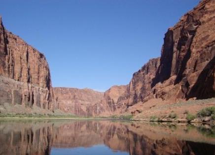
Glen Canyon's Utah segment unfolds across the Colorado Plateau in
Kane and San Juan counties, a high-desert expanse of Navajo and Wingate
sandstone formations sculpted by erosion into a maze of over 2,000 side
canyons, many accessible only by boat or hike. The landscape transitions
from the lake's submerged lower canyon (now a fluctuating aquatic realm)
to the upper reaches' Escalante Canyons and Paria Plateau, where sheer
walls plunge 1,000 feet to narrow slot gorges like Wire Pass and
Buckskin Gulch—among the longest continuous slots in the world at 13
miles. Elevations range from 3,700 feet at the dam to over 6,500 feet in
the Kaiparowits Plateau, with the Orange Cliffs offering panoramic
vistas of the Henry Mountains and distant Grand Staircase-Escalante
National Monument. The Colorado River's ancient path is etched in layers
of Mesozoic-era rock, revealing fossils and colorful cross-bedding that
tell 200 million years of geologic history.
The climate is classic
high-desert arid: scorching summers with highs exceeding 100°F (38°C)
from June to August, cooled by monsoonal thunderstorms; mild springs and
falls ideal for exploration (60-80°F or 16-27°C); and cold winters
dipping below freezing with occasional snow at higher elevations. Annual
precipitation averages just 6-8 inches, mostly in summer flashes that
can cause flash floods in slots— a deadly hazard, as seen in the 2015
Antelope Canyon tragedy. The dry air and intense UV radiation demand
precautions, while the reservoir's evaporation exacerbates regional
water scarcity.
At Glen Canyon's core is Lake Powell, a 186-mile-long impoundment that drowns the canyon's lower reaches, creating a surreal "finger lake" with 2,000 miles of serpentine shoreline—more than the U.S. Pacific Coast. In Utah, highlights include the solitary Escalante Arm, Bullfrog Basin (a major marina hub), and the remote Dirty Devil Arm, where houseboaters navigate turquoise waters amid redrock amphitheaters. Above the high-water mark (3,700 feet), the "bathtub ring" of bleached sandstone reveals pre-dam beaches, while emerging "bathtub islands" like Dangling Rope Marina (closed since 2022 due to low water) expose lost canyons. Rainbow Bridge, accessible via a 1.5-mile hike from the lake, arches 290 feet high, a Navajo sacred site co-managed with the tribe. Horseshoe Bend Overlook, just south in Arizona but often accessed from Utah via Highway 89, provides a vertiginous view of the river's iconic meander. Glen Canyon Dam itself, a concrete behemoth near Page, Arizona, generates up to 1,320 megawatts of power but has sparked controversy for altering ecosystems downstream in the Grand Canyon.
GCNRA's Utah side excels in diverse pursuits, leveraging the lake's accessibility and the backcountry's wildness. Water-based recreation dominates: boating (rentals at Wahweap or Bullfrog Marinas), kayaking through narrow defiles, and fishing for smallmouth bass, walleye, and striped bass amid submerged cottonwoods. Houseboating is legendary, with fleets exploring remote coves for "slot hikes" to hidden waterfalls or ancient ruins. On land, the 1.25 million acres host over 1,000 miles of OHV trails for off-road enthusiasts (permit required, $6 for 7 days), while hikers tackle the 13-mile Paria-to-Lee's Ferry Trail or the challenging Coyote Gulch in Grand Staircase-Escalante. Backcountry camping is primitive and free (permit needed for groups over 15), with stargazing under dark skies rated Bortle Class 2. Cultural sites like the Hole-in-the-Rock pioneers' wagon trail offer interpretive history, and aerial tours reveal the canyon's fractal complexity. As of 2025, fire restrictions were lifted on August 29, allowing campfires in rings, but ORV use remains regulated per the January 2025 federal rule to protect fragile soils and archaeology.
As of September 8, 2025, Lake Powell's water level hovers at 3,547.27 feet (full pool is 3,700 feet), down about 20 feet since January and 30 feet from September 2024, reflecting a projected water year 2025 inflow of 4.84 million acre-feet—50% of average due to prolonged drought and upstream diversions. This decline, driven by climate change and overuse, has stranded boats at marinas like Bullfrog (minimum operating level 3,575 feet) and exposed relics like a 1999 submerged vehicle, but also revealed "new" land for hiking. Hydropower output is at risk, with forecasts warning of drops below 3,490 feet by 2026, potentially halting generation. Environmental concerns include sediment buildup (reducing capacity by 10% since 1963), invasive species like quagga mussels, and downstream impacts on endangered humpback chub from altered flows. Conservation efforts, including the 2025 NPS rule prohibiting motorized craft in sensitive areas, aim to mitigate erosion and protect cultural sites from looting. Recent news highlights a body recovered from the receding lake, underscoring safety risks, while advocates push for dam removal or "fill Mead first" strategies to restore the canyon's natural flows.
Access the Utah side primarily via U.S. Highway 89 from Page, Arizona (45 miles south of Kanab, Utah), or State Route 12 to Escalante for the eastern arms; Bullfrog Marina is reachable via a 7-mile ferry from Halls Crossing or a rough dirt road from Blanding. Entrance fees are $30 per vehicle (7 days) or $15 per person; annual passes available. As of September 2025, conditions are favorable with mild weather (70-85°F), but check nps.gov/glca for alerts—flash flood potential remains high in slots. Launch ramps at Wahweap and Bullfrog are operational above 3,540 feet, but houseboat rentals may be limited; book via Aramark (lakepowell.aramark.com). Pack ample water (1 gallon/person/day), sun protection, and a satellite communicator—cell service is spotty. No drones or off-trail hiking near ruins; respect tribal protocols at Rainbow Bridge. Ideal for fall visits: fewer crowds, vibrant cottonwoods, and accessible beaches. Whether gliding across the lake's glassy expanse or scrambling through sun-dappled slots, Glen Canyon rewards the adventurous with a profound connection to the Southwest's wild soul, a fragile paradise where water's ebb reveals the earth's enduring secrets.