Location: Blaine, Boise, Custer, Elmore counties, ID Map
Area: 217,088 acres (878 km2)
The Sawtooth Wilderness is a vast, federally protected wilderness area in central Idaho, renowned for its dramatic alpine scenery, jagged peaks, and pristine glacial lakes. Spanning 217,088 acres (87,852 hectares), it is one of the largest wilderness areas in the contiguous United States and forms the core of the broader Sawtooth National Recreation Area (SNRA), which encompasses 756,000 acres. Managed by the U.S. Forest Service (USFS) within the Sawtooth National Forest, the wilderness emphasizes non-motorized recreation and ecological preservation under the Wilderness Act of 1964. It features over 50 peaks exceeding 10,000 feet, hundreds of alpine lakes, and nearly 350 miles of trails, offering a rugged escape into the heart of the Rocky Mountains. Established in 1972, the area attracts over 500,000 visitors annually for hiking, backpacking, fishing, and wildlife viewing, while its remote terrain challenges even experienced adventurers. The name "Sawtooth" derives from the serrated, saw-like ridges of the mountain range, evoking a sense of untamed wilderness that has inspired poets, climbers, and conservationists alike.
Nestled in the Sawtooth Mountains—a subrange of the Rocky
Mountains—the Sawtooth Wilderness lies in Blaine, Boise, Custer, and
Elmore counties, approximately 100 miles northeast of Boise and 50 miles
northwest of Sun Valley. The nearest towns are Stanley (population ~100)
to the north and Ketchum to the south, with primary access via State
Highway 21 (the Ponderosa Pine Scenic Route) and Forest Service roads.
The wilderness is bordered by the Salmon River Mountains to the east,
the Boise Mountains to the west, and the White Cloud Mountains to the
southeast, forming part of the vast 2.1-million-acre Sawtooth National
Forest that extends into Utah.
Geologically, the area is a testament
to Ice Age glaciation and tectonic uplift. The Sawtooth Range consists
of Precambrian quartzite and schist, eroded into sharp, knife-edge
ridges over millions of years. Elevations range from 6,000 feet in the
valleys to 10,751 feet at Thompson Peak, the highest point. The
landscape is dominated by U-shaped glacial valleys, cirques, and
moraines, with over 300 lakes—mostly alpine and fed by
snowmelt—scattered throughout. Notable water features include the Salmon
River (headwaters on the east), the South Fork Payette River (west), and
the Boise River (south). The terrain transitions from dense coniferous
forests in lower elevations to alpine tundra above treeline, with
meadows bursting in wildflowers during summer. The area's hydrology
supports the Snake River watershed, making it a critical headwaters
region. As of September 2025, the region experiences a semi-arid to
subalpine climate: summers are mild (daytime highs 70–80°F) but short,
with potential afternoon thunderstorms; winters are harsh, with heavy
snowfall (up to 300 inches annually) and temperatures dropping to -20°F.
Precipitation averages 30–40 inches yearly, mostly as snow, leading to
frozen lakes until mid-July in higher elevations.
Human presence in the Sawtooth region dates back over 10,000 years,
with evidence of Paleo-Indian hunters using the area for big game like
mammoth and bison. By 500 AD, Shoshone-Bannock and Northern Paiute
peoples inhabited the valleys, relying on salmon runs, camas root
gathering, and seasonal migrations for hunting elk and deer.
Euro-American exploration began in the mid-19th century with fur
trappers and miners; the 1860s gold rush in the Boise Basin brought
settlers, leading to conflicts and displacement of Indigenous groups.
The area saw limited logging and mining booms, including a controversial
1968 molybdenum deposit discovery near Castle Peak that spurred
conservation efforts.
Conservation history accelerated in 1905 when
President Theodore Roosevelt established the Sawtooth National Forest to
protect watersheds and timber resources. In 1937, the USFS designated
145,000 acres as the Sawtooth Primitive Area, prohibiting roads and
commercial development. The modern wilderness movement gained momentum
in the 1960s, led by Idaho Senator Frank Church, who championed the
Wilderness Act and feared mining threats. Despite proposals for national
park status, the 1972 Sawtooth National Recreation Area Act (Public Law
92-400) created the SNRA and designated 217,000 acres as wilderness,
balancing recreation with preservation. This act also banned new mining
claims and logging, though some pre-existing operations persisted until
the 1980s. The dedication ceremony at Redfish Lake in 1972 highlighted
its role as a "crown jewel" of American wilderness.
Culturally, the
Sawtooth holds spiritual significance for the Shoshone-Bannock and other
tribes, who view it as a sacred landscape for vision quests and
ancestral ties. Today, it symbolizes the American wilderness ethos,
influencing literature (e.g., Norman Maclean's reflections) and
environmental policy. Archaeological sites, including petroglyphs and
pithouses, are protected, though visitation is limited to prevent
disturbance.
The Sawtooth Wilderness is defined by its iconic alpine features
rather than built structures, adhering to wilderness principles of
minimal human impact—no roads, buildings, or mechanized transport are
allowed.
Peaks and Ridges: The sawtooth skyline boasts at least
50 summits over 10,000 feet, including Thompson Peak (10,751 ft), Mount
Regan (10,639 ft), and Mount Cramer (10,464 ft). These granite spires
offer world-class rock climbing, with routes like the Elephant's Perch
(a 2,000-foot granite wall) drawing experts.
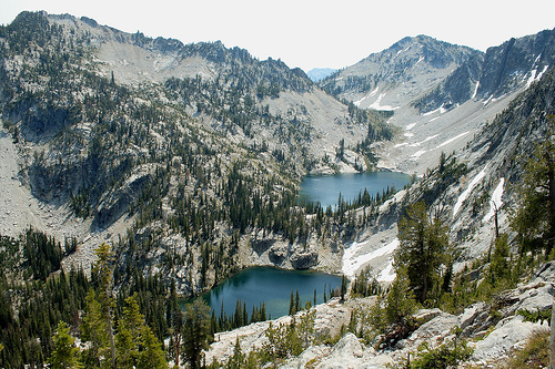
Lakes and Glaciers: Over
300 glacial lakes dot the landscape, many accessible only by trail.
Sawtooth Lake (one of the largest, at 1,100 acres) mirrors the peaks
dramatically; Alice Lake, Toxaway Lake, and the Alpine Lakes
Wilderness-adjacent Baron Lakes are highlights for their turquoise
waters and backcountry camping. Small glaciers, like the one on Thompson
Peak, persist in shaded cirques.
Trails and Route Finding:
Approximately 350 miles of trails crisscross the area, maintained by the
USFS and volunteers from the Sawtooth Society. Key routes include the
67-mile Sawtooth Wilderness Loop (challenging, multi-day backpack), the
20-mile hike to Alpine Lake, and the Iron Creek to Sawtooth Lake Trail
(moderate, 10 miles round-trip). Forty-two designated trails cover about
270 miles, but off-trail travel in trailless basins like the Baron Creek
area requires route-finding skills. Trailheads include Redfish Lake,
Pettit Lake, and Stanley Lake, with some accessible by horseback.
Ecosystems: Diverse habitats range from riparian zones along streams to
subalpine forests of lodgepole pine, Engelmann spruce, and subalpine
fir. Meadows support wildflowers like lupine and paintbrush in
July–August. Fauna includes mule deer, elk, moose, black bears, mountain
lions, and wolverines; gray wolves, reintroduced in the 1990s, roam
packs here. Birdlife features peregrine falcons and bald eagles, while
bull trout indicate water quality. No grizzly bears currently, though
reintroduction discussions continue amid controversy over livestock
conflicts.
As of September 9, 2025, the Sawtooth Wilderness is open year-round,
but summer (July–September) is prime for access, with trails snow-free
above 9,000 feet by late July. Winter offers snowshoeing and backcountry
skiing, though avalanches are a risk. Entry is free, but a mandatory
free Wilderness Use Permit is required for all overnight trips (day
hikes exempt); self-issue at trailheads or online via recreation.gov.
Group sizes are limited to 8 people (or 12 for stock parties), with
200-foot campsite setbacks from trails/lakes. No reservations for
campsites—first-come, first-served.
Activities focus on primitive
recreation:
Hiking and Backpacking: Over 700 miles of trails in
the SNRA, with wilderness-specific routes like the 72-mile loop from
Atlanta to Stanley. Expect 5–10 miles/day; permits track use to prevent
overuse.
Fishing and Hunting: World-class cutthroat trout in lakes;
licenses from Idaho Fish and Game required. Deer/elk seasons in fall.
Climbing and Mountaineering: Technical routes on peaks; helmets and
ropes essential.
Horsepacking: Allowed with certified stock; manure
packing encouraged.
Winter Sports: Cross-country skiing on frozen
lakes; no grooming.
Access: Drive to trailheads via ID-21;
shuttles from Stanley. Fees apply for SNRA entry ($5/vehicle, or $30
annual). Pets allowed on leash; pack out waste (human and dog). For
maps, use the Sawtooth Mountain Trail Maps from the Sawtooth Society.
Crowds peak mid-summer; early September offers solitude with lingering
wildflowers and fewer bugs.
Preservation is paramount: No mechanized equipment, fires only in
designated rings (stoves preferred due to fire bans), and Leave No Trace
principles enforced. The USFS monitors impacts like erosion and bear
habituation, with trail maintenance funded by partnerships like the
Sawtooth Society. Invasive species (e.g., cheatgrass) and climate change
pose threats—warmer temps have shortened winters and stressed water
levels, with some lakes receding.
As of 2025, a June update
reaffirmed permit requirements amid rising visitation post-COVID. No
major closures reported, but flash floods and wildfires (e.g., 2024's
Valley Fire nearby) prompt alerts—check fs.usda.gov/sawtooth for
real-time conditions. Ongoing grizzly reintroduction debates highlight
tensions between conservation and ranching. In 2024, a $1.2 million
grant supported trail rehabilitation, enhancing accessibility while
preserving wild character. Tribal consultations with the
Shoshone-Bannock emphasize co-stewardship, integrating traditional
knowledge into management.
The Sawtooth Wilderness embodies
resilience and raw beauty, a sanctuary where visitors can disconnect and
reconnect with nature's grandeur, reminding us of the fragile balance
between human exploration and environmental stewardship.