Location: Atacama
Alt. Vallee de la Luna
Age: 23 million years
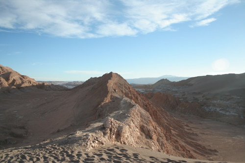
Valle de la Luna, or Moon Valley, is a striking geological formation in northern Chile's Atacama Desert, often described as an otherworldly lunar landscape due to its eroded rock formations, salt-encrusted plains, and dramatic dunes. Located approximately 13 kilometers (8 miles) west of the town of San Pedro de Atacama in the Antofagasta Region, it forms part of the Reserva Nacional Los Flamencos and was declared a Nature Sanctuary in 1982 to protect its unique natural environment. Spanning about 500 hectares (1,235 acres) within the larger Cordillera de la Sal (Salt Mountain Range), the valley attracts around 100,000 visitors annually for its surreal scenery, which has served as a testing ground for Mars rovers and a filming location for sci-fi productions. Its name derives from the moon-like terrain, sculpted over millions of years, making it a symbol of the Atacama's extreme aridity and geological wonders. As of 2025, it remains a flagship destination in Chile's burgeoning adventure tourism sector, bolstered by new safety regulations.
Valle de la Luna is situated at coordinates around
22°55′S 68°15′W, in the hyper-arid core of the Atacama Desert, one of
the driest places on Earth, where some areas receive less than 1 mm
(0.04 inches) of rainfall annually, and certain spots have gone
centuries without precipitation. The valley lies within the Cordillera
de la Sal, a fold-and-thrust belt formed from ancient evaporite
deposits, featuring undulating terrain with elevations ranging from
2,400 to 2,600 meters (7,874–8,530 feet) above sea level. Key
geographical elements include vast salt flats (salares), dry lake beds
coated in white halite crystals, deep canyons, towering sand dunes like
the Duna Mayor (Great Dune), and eroded rock spires resembling
amphitheaters or sculptures. The landscape transitions from pinkish hues
in daylight to deep purples and blacks at dusk, influenced by mineral
compositions and shadows.
The climate is extreme desert (BWk under
Köppen classification), with daytime temperatures soaring to 25–30°C
(77–86°F) and dropping to near-freezing at night due to high diurnal
variation. Humidity is minimal (often below 10%), and strong winds
sculpt the terrain while carrying fine dust. Occasional "Bolivian
winter" rains (January–March) can cause flash floods, reshaping
channels, but overall aridity dominates, supported by the rain-shadow
effect of the Andes and the cold Humboldt Current offshore. This creates
a stark, barren environment, contrasting with nearby oases like San
Pedro de Atacama.
The valley's geology is dominated by Miocene-era
sedimentary deposits, including sandstones, conglomerates, and
evaporites like gypsum and halite, formed in ancient lacustrine (lake)
environments during wetter periods. Over millions of years, tectonic
uplift from the Nazca Plate subduction beneath the South American Plate
raised these layers, while wind erosion (aeolian processes) and rare
water flows carved the terrain into pinnacles, ridges, and canyons. Salt
weathering—where halite crystals expand and fracture rocks—further
accentuates the sculpted forms, creating features like the Amphitheater
(a natural rock bowl) and Las Tres Marías (three pillar-like formations
resembling praying figures).
Unique geological highlights include
salt caves in the Cañón de la Sal, fossilized dunes, and stratified
layers revealing paleoclimatic history, with some rocks dating back 23
million years. The valley's Mars-like appearance stems from iron oxide
staining (rusty reds) and minimal vegetation, making it a terrestrial
analog for extraterrestrial studies. Scientifically, it provides
insights into arid geomorphology and has been used by NASA to test
rovers, highlighting processes like deflation (wind removal of fine
particles) and yardang formation (streamlined ridges).
Indigenous peoples, including the Atacameño (Lickanantay), have inhabited the region for over 11,000 years, using nearby oases for agriculture and viewing the valley as a sacred or resource site for salt extraction. European exploration began in the 16th century with Spanish conquistadors, but significant attention came in the 20th century with geological surveys. The area gained fame in the 1960s–1970s for its lunar resemblance, coinciding with the Space Race. In 1982, it was declared a Nature Sanctuary under Chile's environmental laws to curb unregulated mining and tourism impacts. Part of broader Atacama conservation efforts, it reflects Chile's post-1970s environmental awakening amid dictatorship-era exploitation. Historically, the valley hosted limited mining, like the Victoria Mine (an old saltpeter site), now a tourist stop.
Biodiversity in Valle de la Luna is limited due to extreme aridity, but the Atacama's xeric ecosystems support adapted species. Flora is sparse, featuring halophytes like saltbush (Atriplex spp.) and drought-resistant cacti (e.g., Echinopsis atacamensis), with microbial mats in saline areas. Fauna includes Andean foxes (Lycalopex culpaeus), vizcachas (Lagidium viscacia), and birds such as Andean condors (Vultur gryphus) and burrowing owls (Athene cunicularia). Endemic microbes and extremophiles thrive in hypersaline soils, contributing to astrobiological research. The valley acts as a corridor in the broader Atacama, where biodiversity hotspots like salares host flamingos and unique invertebrates, but human pressures threaten these fragile systems.
Managed by CONAF (Chile's National Forestry Corporation) as part of Reserva Nacional Los Flamencos (IUCN Category IV), the valley's sanctuary status prohibits mining and limits development. Efforts include trail maintenance, visitor quotas (e.g., 12 per group), and erosion monitoring. Chile's broader environmental framework, including Clean Production Agreements, supports sustainable tourism. Partnerships with NGOs like WWF address regional threats, while the Route of Parks initiative indirectly benefits northern sites. As of 2025, new adventure tourism regulations mandate "R Seal" accreditation for operators, ensuring safety and environmental compliance.
Primary threats include overtourism causing trail erosion and dust pollution, climate change exacerbating aridity and flash floods, and regional mining (e.g., lithium extraction) leading to water depletion and habitat fragmentation. Green hydrogen projects in Chile pose emerging risks to wildlife through infrastructure in arid zones. Illegal off-roading and waste dumping persist, while warming seas indirectly affect coastal-dependent species. Studies highlight habitat loss from agriculture and resource extraction as key regional issues.
Tourism centers on guided half-day or sunset tours from San Pedro de Atacama, including hikes to Duna Mayor Viewpoint (40 minutes), Tres Marías (15 minutes), Victoria Mine (30 minutes), and Ckari Viewpoint (60 minutes). Activities involve exploring salt caves, climbing dunes, and sunset watching, with groups limited to 12 for sustainability. Access requires online tickets (CLP 10,000 adults, CLP 5,000 concessions) via valledelalunachile.com; open 8 AM to 4 PM (last entry). Best visited late afternoon for color shifts; tips include sturdy shoes, layers, water, and sunscreen. Costs: Tours ~$67 USD. In 2025, visa-free entry for 94 countries boosts access, with new safety regs enhancing experiences.
As a Mars analog, the valley hosts astrobiology and geology research, with NASA rover tests in the 2000s. Studies focus on extremophiles, erosion processes, and paleoclimatology via stratified rocks. It contributes to understanding arid ecosystems and climate resilience, with ongoing monitoring by Chilean universities and international teams.
As of August 2025, Chile's new "R Seal" adventure tourism regulations, effective this year, require operator accreditation for safety, impacting Valle de la Luna tours. In 2024, visa-free policies for 94 countries surged visits. No major incidents reported, but green hydrogen debates highlight conservation needs. A 2025 guide emphasizes sustainable practices amid growing popularity.