Location: Huila and Caqueta Provinces Map
Area: 90.78 km²
Cueva de los Guácharos National Natural Park (Parque Nacional Natural Cueva de los Guácharos) holds the distinction of being Colombia's oldest protected area, established on November 9, 1960, through Decree 2631 as the nation's first national park. Spanning approximately 7,135 hectares (though some sources cite 9,000 hectares), the park is situated on the western flank of the Eastern Andean Range, marking a transitional zone between the Andean highlands and the Amazonian piedmont. It straddles the departments of Huila, Caquetá, and Cauca, encompassing municipalities such as Acevedo and Palestina in Huila, San José del Fragua and Belén de Los Andakíes in Caquetá, and Piamonte in Cauca. The park's name derives from the guácharos (oilbirds, Steatornis caripensis), nocturnal fruit-eating birds that inhabit its iconic caves, a species first scientifically described by Alexander von Humboldt in 1799. As part of the UNESCO-declared Andean Belt Biosphere Reserve since 1979, it plays a crucial role in preserving one of Colombia's most biodiverse and ecologically sensitive regions.
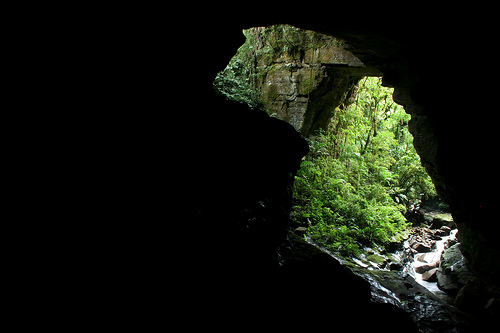
The park's terrain is rugged and mountainous, with
elevations ranging from 1,800 to 3,000 meters above sea level. It
features karstic landscapes shaped by rivers such as the Suaza (also
known as Fragua) and its tributaries, which have carved out deep
canyons, natural bridges, and a network of caves, including the namesake
Cueva de los Guácharos and Cueva del Indio. These formations are
primarily calcareous, resulting from the dissolution of limestone over
millennia. The park serves as a hydrological regulator, with several
vital water sources originating here, including the Río Fragua Grande, a
major tributary of the Alto Caquetá, ensuring water supply for
downstream communities. Ecosystems include well-preserved Andean and
sub-Andean cloud forests (covering about 28% of the area in the
Amazonian piedmont) and páramo highlands, creating a mosaic of habitats
that bridge the Andes and the Amazon.
Climate in the park is
typically cool and humid, characteristic of Andean cloud forests, with
high rainfall supporting dense vegetation. Temperatures can vary
significantly with elevation, often ranging from mild in lower areas to
colder in the higher páramos. While specific data is sparse, the
region's transitional nature means it experiences wet seasons that
enhance its lush, misty atmosphere, ideal for its biodiversity.
The park's establishment in 1960 marked a pioneering step in Colombia's conservation efforts, initially aimed at protecting the unique oilbird populations and the surrounding cloud forests. It is governed by Colombia's National System of Protected Areas (SINAP) and celebrated its 50th anniversary in 2011. Historically, the area has been inhabited by indigenous groups, and the guácharo cave holds spiritual and symbolic value for local indigenous and peasant communities, who view it as a sacred site. The park is functionally connected to adjacent protected areas like PNN Alto Fragua Indi Wasi and Serranía de los Churumbelos Auka Wasi, forming a broader biological corridor. Despite challenges like historical deforestation on its eastern flanks (now largely converted to cattle ranches), the core area remains one of the last intact oak forests in Colombia.
Cueva de los Guácharos is a biodiversity hotspot,
safeguarding a rich array of species in its Andean-Amazonian transition
zones.
Flora: The park protects some of Colombia's last remaining oak
forests, featuring species like the black oak (Trigonobalanus excelsa),
white oak (Quercus humboldtii), yolombó (Panopsis spp.), comino (Aniba
spp.), black cedar (Juglans neotropica), hayuelo pine, and Colombian
pine. Other notable plants include lauraceae family members and the Seje
or Milpes palm (Jessenia polycarpa), which provides essential food for
wildlife but is absent from higher elevations. These forests are
critical for endangered flora facing extinction pressures.
Fauna: The
park hosts over 300 bird species, making it a premier birdwatching
destination. Key avian residents include the emblematic oilbird, which
uses echolocation to navigate caves and feeds on fruits and insects; the
Andean cock-of-the-rock (Rupicola peruvianus); yellow-eared parrot
(Ognorhynchus icterotis); torrent duck; crested eagle; silvery grebe
(Podiceps occipitalis); and the endemic olive-backed brush-finch
(Atlapetes olivaceus). It also serves as a seasonal stop for migratory
birds.
Mammals are equally diverse, with endangered species such as
the Andean bear (Tremarctos ornatus), spectacled bear, mountain tapir
(Tapirus pinchaque), northern pudu (Pudu mephistophiles), oncilla
(Leopardus tigrina), puma (Puma concolor), cougar, long-tailed weasel,
woolly monkey (Lagothrix lagotricha lugens), spider monkey (Ateles
paniscus), capuchin monkey (Cebus apella), red brocket deer (Mazama
americana), and dwarf red brocket (Mazama rufina). Conservation statuses
range from vulnerable to data deficient, highlighting the park's role in
protecting these populations.
The dense forests and rivers create a
vibrant soundscape, with rushing waters, bird calls, and nocturnal
oilbird activity adding to its ecological richness.
As a UNESCO Biosphere Reserve component, the park is vital for conserving endangered species, regulating regional water cycles, and maintaining ecological connectivity in the Andean-Amazon corridor. Threats include historical deforestation and climate change, but its protected status helps mitigate these. Community involvement, including indigenous groups, underscores its cultural conservation value, with the guácharo symbolizing harmony between nature and local traditions.
Primary attractions include the guácharo-inhabited
caves, where visitors can observe these birds roosting by day and
emerging at dusk—a spectacle especially notable during hatching season
(March-April). Other highlights are waterfalls, natural bridges, and
hiking trails through oak forests and páramos. Activities encompass:
Hiking: Authorized trails for exploring forests, canyons, and
rivers.
Birdwatching: Ideal for spotting rare species, for
recreation, research, or education.
Spelunking: Exploring caves like
Cueva del Indio, requiring specialized equipment and physical fitness.
Camping: In designated sites, such as Centro de Visitantes Andaquí.
Other: Sound recording of natural ambiences, wildlife observation, and
educational tours.
All activities emphasize low-impact
ecotourism.
Access: The park is about 188 km south of Neiva, with
main entry from Pitalito (5-6 hours total journey). From Pitalito, take
a jeep or bike 23 km to Palestina village, then hike or drive 15 km
uphill on dirt roads to the entrance. Alternative old mountain trails
exist but require local guides.
Entry and Regulations: Open 8 am to 2
pm for entry (arrive by 7 pm max); trails and caves from 8 am to 3 pm,
return by 6 pm. Visitors must be accompanied by an authorized guide;
independent entry may be restricted. Reservations via Fundación Cerca
Viva (phone: 322 9771464, email: fundacioncercaviva@gmail.com). Entry
fees apply (not specified here), and services like lodging, meals, and
guides are extra, provided by community operators.
Best Time to
Visit: Year-round, but March-April for oilbird hatching. Avoid heavy
rains for safer hiking.
Accommodations and Tips: Basic camping at
park facilities (noted as sometimes neglected); nearby fincas offer
stays. Bring sturdy gear for hiking/caving, rain protection, and
binoculars. Good physical condition is essential due to steep terrain
and river crossings. Respect rules: no unguided exploration, minimize
noise, and support local ecotourism. For a deeper experience, engage
with indigenous guides for cultural insights.
This under-visited gem
offers an immersive escape into Colombia's natural heritage, blending
adventure with conservation.