Location: Department of Meta Map
Area: 6,200 km²
Serranía de la Macarena is an isolated mountain range and biodiversity hotspot in the Meta Department of Colombia, renowned for its unique convergence of ecosystems from the Amazon, Andes, and Orinoco regions. Spanning approximately 6,200 square kilometers (2,400 square miles), it was designated as Parque Nacional Natural Serranía de La Macarena in 1971, making it one of Colombia's oldest national parks. The area is celebrated for Caño Cristales, often called the "River of Five Colors" or "Liquid Rainbow," due to its vibrant aquatic plants that create a multicolored spectacle. This UNESCO-recognized site (as part of broader Amazon protections) serves as a critical ecological corridor, protecting ancient geological formations, diverse wildlife, and cultural heritage sites like petroglyphs. As of August 2025, the park faces ongoing conservation challenges amid Colombia's national efforts to curb deforestation, while promoting sustainable tourism that highlights its "megadiverse" status.
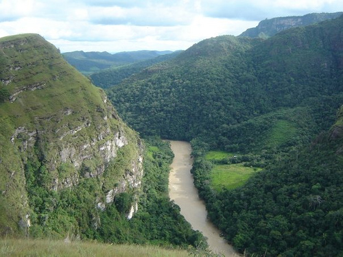
Geographically, Serranía de la Macarena is an isolated serranía
(mountain range) separated from the Eastern Andes by about 40 kilometers
(25 miles) of lowlands, extending 120 kilometers (75 miles) north-south
and 30 kilometers (19 miles) east-west. Located at approximately 2°20′N
73°50′W, it rises abruptly from the surrounding plains, with elevations
ranging from 200 meters (656 feet) in the lowlands to 2,615 meters
(8,579 feet) at its highest peak, El Gobernador. The landscape features
rugged plateaus, deep canyons, waterfalls (e.g., Caño Canoas, El Salto
de Yarumales), and river systems like the Guayabero and Güéjar, which
carve through ancient rock formations. The park encompasses diverse
habitats, including flooded forests (várzea), dry forests, shrublands,
savannas, and the iconic Caño Cristales river basin, where Macarenia
clavigera plants create colorful displays.
Geologically, the range
consists of Precambrian Guyana Shield basement rocks overlain by
Paleozoic to Oligocene sandstones and conglomerates from the Vaupés
Formation. These sediments, deposited in ancient valley fills, have been
uplifted and eroded over millions of years, forming dramatic features
like natural arches and pillars.
The climate is tropical, with
average temperatures between 5.5°C (42°F) at higher elevations and 31°C
(88°F) in lowlands, and high humidity supporting lush vegetation. Annual
rainfall exceeds 3,000 millimeters (118 inches), peaking during the wet
season (April–November), leading to seasonal flooding that enriches
soils but causes river level fluctuations up to 10 meters (33 feet). The
drier period (December–March) offers clearer skies and better access,
though climate change is intensifying extremes, such as prolonged
droughts and heavier rains.
The region's history dates back to pre-Columbian times, with evidence
of ancient cultures through petroglyphs at sites like Angosturas I and
II along the Guayabero River, depicting human figures and animals from
as early as 12,000 years ago. Indigenous groups, including the Tinigua
and Guayabero peoples, inhabited the area, adapting to its diverse
ecosystems. Spanish explorers in the 16th century noted the serranía's
isolation, but significant settlement occurred in the 20th century amid
rubber booms and colonization.
Conservation history began with the
establishment of Colombia's first national reserve in the central
Macarena in 1948 via Congressional Law, initially protecting 1,300
square kilometers. This expanded to a National Natural Park in 1971,
covering 6,200 square kilometers, driven by efforts to halt hunting
(e.g., jaguars for skins) and logging. The park's creation aligned with
global environmental movements, influenced by figures like Julia Allen
Field, who advocated for protection in the 1970s. Named after the Virgin
of Hope of Macarena, the area has also been affected by Colombia's armed
conflict, with FARC guerrillas using it as a stronghold until the 2016
peace agreement, which initially spurred deforestation but later enabled
better management.
Serranía de la Macarena is a megadiverse enclave, hosting over 2,400
plant species (including 50 orchids) and serving as a biological bridge
between three major biomes. Flora includes endemic species like the
Macarenia clavigera (responsible for Caño Cristales' colors), giant
water lilies, and canopy trees adapted to flooding. Ecosystems range
from rainforests to savannas, supporting high endemism.
Fauna is
equally rich, with over 500 bird species (e.g., gray-legged tinamou,
wattled curassow), 1,200 insects, 100 reptiles (including anacondas),
and 8 primate species (e.g., woolly monkeys). Mammals include jaguars,
cougars, anteaters, deer, and tapirs, while aquatic life features pink
river dolphins and Amazonian manatees in nearby rivers. The park
protects at least 48 threatened species, with biodiversity inventories
ongoing to document its role in regional connectivity. This richness
stems from its isolation and varied altitudes, fostering unique
evolutionary adaptations.
Classified as IUCN Category II (National Park), Serranía de la
Macarena is managed by Parques Nacionales Naturales de Colombia under
the National System of Protected Areas (SINAP). Conservation focuses on
habitat restoration, anti-deforestation patrols, and community
involvement, including indigenous groups like the Tinigua. Initiatives
like Heritage Colombia (HECO), funded by WWF and others, aim to enhance
ecosystem services (e.g., carbon sequestration, erosion control) valued
at millions annually. The park integrates with adjacent reserves,
forming a larger protected corridor.
Efforts include reforestation,
wildlife monitoring, and sustainable livelihood programs for locals,
such as ecotourism guiding. International partnerships, like those with
the World Bank and WWF, support biodiversity assessments and climate
resilience strategies. As of 2025, Colombia's government has expanded
protections amid threats, emphasizing the park's role in national
biodiversity goals.
Despite protections, the park faces severe threats from deforestation, which surged 35% nationally in 2024, with 3,361 hectares lost in Macarena alone due to cattle ranching, armed groups, and illegal logging. Post-2016 peace agreement deforestation accelerated habitat fragmentation, while climate change intensifies droughts and floods, altering river dynamics and plant blooms. Fires, with alerts in July 2025 affecting coverage, pose additional risks amid drier conditions. Regional issues include mining, oil exploration, and human-wildlife conflicts, exacerbated by weak enforcement in remote areas. Armed actors continue to influence land use, hindering patrols and community programs.
Tourism centers on eco-adventures, with the 2025 season for Caño Cristales running from June to November, peaking in September–October for optimal colors. Activities include guided hikes to viewpoints like Mirador del Amor, river canoeing, waterfall visits (e.g., Soplaculos), and petroglyph explorations. Botanical gardens near La Macarena offer restoration workshops. Access is via flights to La Macarena town, followed by boat or 4x4 transfers; permits and guides are mandatory for sustainability. Costs range from USD 100–300 for tours, emphasizing low-impact practices. The park attracts nature enthusiasts for birdwatching, photography, and cultural immersions with indigenous communities.
The park is a key site for studying biogeography, endemism, and ecosystem connectivity, with research on Caño Cristales' aquatic plants informing climate resilience models. Institutions like WWF and Colombian universities conduct biodiversity inventories, seed dispersal studies, and deforestation mapping using remote sensing. Its role as a "biological remix" aids global understanding of tropical transitions, contributing to policies on protected areas. Recent studies (2024–2025) focus on post-conflict land use changes and carbon storage, supporting international databases.
As of August 2025, fire alerts in July detected impacts on forested areas within the park and nearby Nukak reserve, prompting monitoring by Colombia's Defensoría del Pueblo. Deforestation rose 35% nationally in 2024, with Macarena losing 3,361 hectares, linked to armed groups and ranching; however, Colombia reported its second-lowest overall rate historically. The 2025 tourism season opened in late May, highlighting Caño Cristales' splendor amid calls for sustainable visits. At COP16 in October 2024, the park was showcased for biodiversity efforts, while WWF's 2023–2024 reports emphasized its ecosystem services amid ongoing threats.