Location: Amman Governorate Map
Amman is located in Jordan, it is the capital and largest city of
the Hashemite Kingdom of Jordan (population approx. 2.1 million).
Amman is an excellent base from which to explore this state, and,
contrary to popular belief, there is something here that deserves
the attention of a traveler. Visit the ancient Roman amphitheater of
Amman, study at Jordanian University or stay in a luxury hotel.
There are many shopping centers here.
Amman is undergoing a
dramatic transformation from a quiet, sleepy province to a bustling
metropolis, some parts of which are serious about imitating Dubai.
Amman's roads have a reputation for being very steep and narrow in
some of the underdeveloped areas of the city, but today the city has
modern highways and paved avenues. Rough terrain and heavy traffic
continue to be a problem for pedestrians and occasional cyclists.
New inns and hotels abound in the city, with plenty to see and do
for the tourist. Use Amman as a starting point for trips to nearby
cities and towns in Jordan.
White-stoned Amman experienced
rapid growth when it became the capital of Transjordan in the early
1920s, but especially after the 1948 and 1967 wars with Israel, when
hundreds of thousands of Palestinian refugees settled here. A new
wave came after the second Iraqi war, when most of the newcomers
were Iraqi refugees.
The history of the city has many
millennia. The settlement, mentioned in the Bible as Rabbat Ammon,
was the capital of the Ammonites, who were subsequently subjugated
by the Assyrians. For a short time it belonged to the Nabateans,
then becoming a major ancient Roman center of trade and being
renamed Philadelphia. After the Islamic conquests, Amman became part
of the Muslim empire until the Turks were forced out by the Allied
forces with the help of the Hashemites, who established a monarchy
that continues to rule to this day.
Today, western Amman is a
vibrant modern city. The eastern part of the city, where the
majority of Amman's residents live, is mostly a working-class
residential area and is much older than the western part. Although
Amman itself has a number of attractions, it serves as a convenient
base for exploring the northwestern regions of the country.
Amman is a very diverse city. Palestinians, Iraqis, Circassians,
Armenians and many other ethnic groups coexist here. Amman was
destroyed as a result of the events of Black September, but the city
was rebuilt. The city is constantly growing. In less than a century,
the city's population has grown from 20,000 inhabitants to over 2
million, thanks in part to massive influxes of refugees from
Palestine and Iraq.
Despite the popular belief that most
Jordanians understand English, their knowledge of the language is
quite limited. The most famous English phrase is "Welcome to Jordan"
(Welcome to Jordan). The only language, besides Arabic, that is used
on signs and signs is English, near major attractions you will find
"Tourist Police" (Tourist Police). It never hurts to know a few
useful phrases and have a phrase book with you, or write the names
and addresses of the places you are going to, written on a piece of
paper in Arabic, for the taxi driver.
By plane
Most visitors to Amman (and Amman) arrive through the
International Airport. Queen Alia International Airport.
Occasionally, regional or charter flights arrive at Marka Airport,
located in the east of Amman, a few kilometers behind the railway
station. Most Western tourists can purchase Jordanian entry visas at
the airport if they have not already received them from a Jordanian
consulate. The visa costs 20 JD ($28) and is payable in dinars only:
at the immigration queue, you pay for your visa at the first window,
then proceed to the second window to have your passport stamped.
Note that there is a whist sign indicating that it is possible to
pay with a bank card, but this is not the case, and you will be sent
for cash. There is a currency exchange before passport control,
there is also one ATM (does not accept MasterCard), there are
several more ATMs after the customs zone. The airport has only one
post office and no mailbox, it is located in the arrivals hall of
Terminal 1 next to the Lost and Found office. If the post office is
closed, you can put your letters/postcards under the curtain.
To get from Queen Alia Airport to Amman itself, there are two
best options: either take a taxi or take the Airport Express bus. A
taxi ride from the airport to the city will cost about 20 dinars
($30). The taxi fare from the airport is fixed. Remember that the
fare is fixed only from the airport to the city, the taxi driver may
try to negotiate with you to take you from the city back to the
airport, often at an inflated price. It is not difficult to get from
the city to the airport for 20 dinars, but if the driver tries to
take more, be firm and say no. Express buses to the airport run
around the clock every 60 minutes (except at midnight, 2 am, 4 am
and 6 am), the fare is 3 dinars. Buses depart only from the bus stop
in front of Terminal 2. The trip from the airport to the Tabarbour
bus station in Amman, stopping at the 7th ring, usually takes 45
minutes to an hour. You can then hail a taxi from the bus station to
your hotel, but beware of taxi drivers trying to rip off the newly
arrived tourist.
The bus stop on the 7th ring is less than
100 m south of the ring. The small yellow bus with the "airport
express" sign is easily recognizable, and the driver will also stop
elsewhere if you wave to him. To get to the 7th ring from the
center, take bus number 41 or any bus bound for Wadi As-Seir and ask
to be dropped off at Dawaar As-Saabe'a (7th ring).
There are,
of course, car rental agencies in Amman as well.
By train
Railway company in Jordan: HJR (Hedjaz Jordan Railway), see seat61
for details. Since around 2005, rail links within Jordan and to
Damascus have unfortunately been halted and are unlikely to resume.
From time to time there are railway excursions, and there is also a
local railway connection with Zarqa (Zarqa). But this happens no
more than once a week, and even less often. However, even if you
don't (or can't) take the train, Amman's tiny, cozy railway station
(Mahatta) with its museum deserves a visit.
By taxi
A taxi
from/to the bridge on the border with Israel costs 25 dinars and
takes one hour. Here, for example, is the number of a taxi driver
who is known for carrying tourists over long distances: 0779037904
Nick Taxi service company & tours.
Transport
Taxi
Yellow and gray taxis are readily available
anywhere in Amman. Just call them on the street like the Jordanians
do. Amman taxis will have a green logo on the driver and passenger
doors. Gray taxis have advertising placed on top of the car. Try not
to stop taxis with logos of a different color: they are based in
other cities and are prohibited by law from charging fares in Amman.
White taxis are shuttles, and the driver can pick up other
passengers along the way, which can cause confusion.
By law,
taxis in Amman must use taximeters, and most taxi drivers turn on
the meter as soon as they pick up a passenger. Most trips within
Amman should cost less than 2-3 dinars, and even a trip from one end
of the city to the other should not cost more than 5 dinars. Taxis
are not required to use taximeters after midnight, and taxi drivers
often charge double the fare for overnight rides. Beware of drivers
offering you a short ride "free" as an "invitation to Jordan",
especially if you're walking between a fortress and an ancient Roman
amphitheatre: they will then offer to wait for you to take you to
your next destination and use the "free" ride as an excuse to
disable the counter. Then they will demand sky-high money from you
upon arrival at your next destination.
The basic taximeter
fare was changed in 2007 from 150 filis (0.150 dinars) to 250 filis
(0.250 dinars) due to rising oil prices, however, not all taxis have
changed their old meters to new ones, and when a taxi uses an old
meter, the taxi driver will legally ask you will have to pay an
additional 10 piastres (100 fillets) over the meter reading.
However, make sure that you note the initial amount as soon as the
taxi driver turns on the meter so that he does not charge you these
"10 piastres" if he has a new meter. Usually taxi drivers are not
tipped, instead the fare is simply rounded up to the nearest 5 or 10
piastres. It should be noted that many taxi drivers do not carry a
lot of change money, so if possible, you should give them money for
settlement. If a taxi driver pretends not to have change, he
probably just wants to keep it so you have to pay more. If you don't
like it, ask the driver to find a nearby store and change money, or
change it yourself in the store, or (if you're not afraid to be
rude) look at the taxi driver's cashier to find change.
The
negotiated taxi fare from Amman to the airport is 20 dinars or more,
although some taxi drivers can be persuaded to 15 or even 10 dinars
(which will be close to the taximeter fare). All taxis are allowed
to take passengers to the airport: only special airport taxis are
allowed to take passengers from the airport to the city.
If
you are going to a fortress, call it al'Aqal. The taxi driver may
try to convince you that the ancient Roman amphitheater is better
(this is so that he can drop you off at the foot of the hill). It
will be better if you are dropped off at the fortress, from where
you can go down the hill to the ancient Roman amphitheater.
Car rental
There are several car rental companies in Jordan,
including international Hertz, Sixt, National. Some of them will
even provide a free driver if you rent a car.
By bus
Large
city buses operate in many parts of Amman. They are used by low-paid
workers, working youth and foreign workers, but they are completely
safe. As of January 2011, the fare was 380 fillis. Pay the exact
amount (or overpay): the driver has no change! It is also possible
to top up a bus fare card with a few dinars and swipe it through the
reader at the entrance to the bus, but places to buy and top up such
a card are rare. Most buses have route numbers, but some only show
the destination in Arabic. Bus number 26 runs very conveniently
between the old city (Balad) and the 7th ring on Zahran street.
Route number 27 runs from the old city towards the chic Abdoun area.
Route number 43 passes near Shmeisani (as well as number 46) and
then goes along Mecca Street to the Mecca Mall. Many bus stops are
visible from the bus stop pavilions, but buses also drop off
passengers at non-safe stops. Private minibuses follow the routes of
city buses. They do not show route numbers, but the conductor
usually calls out the destination.
You can visit the amazing
ancient Roman amphitheater and nymphaeum, representing the
historical heritage of the city, as well as the bewitching Fortress,
which has been standing since the ancient Ammonites. You can take a
leisurely stroll through the King Hussein Park and visit the
Automobile Museum, which displays the late King Hussein's car
collection, or the Children's Museum.
Of interest is the
Jabal Amman 1st Circle Walking Trail with coffee shops and
magnificent traditional villas. There is a leaflet describing the
route at the Wild Jordan Cafe.
If shopping is your thing, the
Wakalat pedestrian shopping area has a great selection of
international fashion brands.
For a more exotic and
traditional experience, you can visit the old city center, also
known as the souk (market), enjoy the traditional sights and flavors
of the spice market, and shop for authentic souvenirs.
Although Amman is the capital of a multi-faceted kingdom, it
cannot be said that it is packed with sights and serves as a gateway
to them. Nevertheless, there are a couple of historical and cultural
monuments in the city (take a maximum of 2 days to study them).
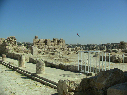
Roman Amphitheatre (Roman
Theatre). entrance 1 dinar. Built in the reign of Antony Pius,
138-161. n. e., this majestic amphitheater could accommodate up to 6
thousand spectators. Next to it are the Folklore Museum and the Pop
Culture Museum, which are included in the admission price.
Amman
Fortress (The Citadel, جبل القلعة, Jabal
al-Qal'a) (located in the heart of the city). A monument of national
history representing significant civilizations and reflecting the
rise and fall of empires. The history of human settlement in this
place exceeds 7 thousand len.
Jordan
Archaeological Museum (located in the Amman Fort). The
museum has a small but interesting collection of antiquities from
all over Jordan. Fragments of the Dead Sea Scrolls, which were
previously exhibited here, are now transferred to the new National
Museum of Jordan.
Temple of Hercules
(located in the Amman Fort). Ruins of the ancient Roman period.
Byzantine Basilica (located in
the Amman Fortress). It belongs to the 5th-6th centuries.
Umayyad
Palace (located in the northern part of the Amman Fort). entrance
ticket 2 dinars. The palace offers a magnificent view of Amman.
Nymphaeum. Ancient Roman fountain.
Ammonite Watch Tower. The
watchtower belongs to the Ammonite era.
Darat al-Funun. The Darat
al-Funun or "little house of art" at Jabal el-Waybdeh, overlooking
the heart of Amman, is housed in three adjacent 1920s villas. (and
in the ruins of a 6th-century Byzantine church built over an ancient
Roman temple), has a permanent exhibition, and also hosts temporary
exhibitions. In the same area there are other small art galleries
and the Jordan National Gallery of Fine Arts.
st. Rainbow
(Rainbow St.) (located at the 1st ring in Jabal Amman). This is an
interesting area to walk and explore. The street is named after the
old Rainbow Cinema, which is now out of business, but the area has
recently been revitalized, many old houses are being restored and
used, there are several cafes and bars in the area, including
Books@cafe and Wild Jordan with great views, baths (Hammam), the
Royal Film Commission (Royal Film Commission), which sometimes
shoots outdoors in the courtyard, as well as a number of interesting
shops. Across the street from the British Council (British Council)
on the street. Rabugi is a cool Turtle Green Tea Bar, where
everything is in English and where you can borrow a laptop for
Internet access during meals.
Cultural life in Amman has somewhat
revived, in particular, given such cultural centers and clubs as the
Makan House, Al Balad Theater, Amman Filmmakers Cooperative, Remall,
Zara Gallery » (Zara gallery). Around September 1, the Jordan Short
Film Festival is held.
Jordan National Gallery of Fine Arts
Amman’s history begins in the Neolithic period, with one of the
world’s oldest known settlements at ‘Ain Ghazal (circa 7250–4500 BCE),
located in northeastern Amman. Excavations uncovered mud-brick houses,
plaster statues (among the earliest large-scale human figures, now in
the Jordan Museum), and evidence of agriculture (wheat, barley) and
animal domestication (goats). ‘Ain Ghazal’s population peaked at around
3,000, making it a significant early community. Its decline around 4500
BCE is attributed to environmental degradation and resource depletion.
During the Early Bronze Age (circa 3200–2000 BCE), Amman emerged as
a regional center within the Ammonite culture, a Semitic group mentioned
in biblical texts. The Amman Citadel (Jebel Al-Qala’a), the city’s
highest hill, was fortified with stone walls, as evidenced by
archaeological finds like pottery and tools. The Ammonites established
Rabbath Ammon (meaning “Great City of the Ammonites”) as their capital,
leveraging its fertile valleys and proximity to the King’s Highway, a
trade route connecting Egypt, Mesopotamia, and Arabia. Tombs from this
period, such as those at Jebel Jofeh, indicate a stratified society with
advanced craftsmanship.
In the Iron Age (circa 1200–539 BCE), Rabbath Ammon solidified its
status as the Ammonite capital. The Ammonites, known for their fortified
cities and polytheistic religion (worshipping deities like Milcom),
clashed with neighboring Israelites, as recorded in the Hebrew Bible
(e.g., 2 Samuel 12:26–31). The Citadel’s massive stone walls, some still
visible, protected against invasions. Archaeological finds, including
seals and inscriptions, confirm Ammonite literacy and trade with
Phoenicia and Egypt.
The Assyrian Empire conquered Rabbath Ammon
in the 8th century BCE under Tiglath-Pileser III, reducing it to a
vassal state. The Amman Citadel Inscription (circa 850 BCE), a basalt
fragment, mentions tribute to Assyria. Subsequent Babylonian (605–539
BCE) and Persian (539–332 BCE) rule integrated the city into their
empires, with Rabbath Ammon serving as a trade and administrative
outpost. Persian influence is evident in pottery and road networks
linking to the Achaemenid capital, Persepolis.
Following Alexander the Great’s conquest of the region in 332 BCE,
Rabbath Ammon was Hellenized and renamed Philadelphia after Ptolemy II
Philadelphus, a Ptolemaic ruler of Egypt (283–246 BCE). Under Ptolemaic
and later Seleucid control, Philadelphia adopted Greek urban planning,
with temples, markets, and theaters. The Amman Citadel housed a Greek
acropolis, though few Hellenistic remains survive due to later Roman
construction.
The city became part of the Decapolis, a loose
confederation of ten Greco-Roman cities, fostering cultural exchange
between Greek and Semitic traditions. Philadelphia’s strategic location
on trade routes, including the Via Nova Traiana, enhanced its
prosperity. Nabataean influence from nearby Petra is evident in pottery
and trade goods, indicating economic ties.
Roman rule began in 63 BCE when Pompey annexed the region,
incorporating Philadelphia into the Provincia Syria and later Provincia
Arabia (106 CE). As a Decapolis city, Philadelphia flourished as a
cultural and commercial center, with significant urban development under
emperors like Trajan and Antoninus Pius. Key Roman monuments, still
visible today, include:
Roman Theatre (138–161 CE): A 6,000-seat
amphitheater carved into Jebel Al-Joufah, built during Antoninus Pius’
reign. Its northern orientation ensured shade, and it hosted plays,
gladiatorial contests, and civic events. Restored in the 20th century,
it remains a cultural venue.
Roman Forum (circa 190 CE): A 100 x
50-meter public square adjacent to the theatre, with Corinthian
colonnades, used for markets and gatherings. Part of it is now the
Hashemite Plaza.
Nymphaeum (191 CE): A monumental public fountain
dedicated to water nymphs, fed by aqueducts along the Seil Amman stream.
Restored in 2013–2015, its niches and basins reflect Roman hydraulic
engineering.
Odeon (2nd century CE): A 500-seat auditorium near the
theatre for musical performances and lectures.
Temple of Hercules
(circa 160 CE): Located on the Citadel, this temple, built under Marcus
Aurelius, features massive columns and a colossal statue fragment,
symbolizing Roman religious and architectural prowess.
Philadelphia’s
Roman infrastructure included aqueducts, roads, and baths, supporting a
population of around 20,000. The city’s economy thrived on agriculture
(wheat, olives, grapes) and trade, with coins minted locally bearing the
city’s name. The Via Nova Traiana, linking Aqaba to Damascus, passed
through Philadelphia, cementing its role as a trade hub.
With the rise of the Byzantine Empire in 324 CE, Philadelphia became
a Christian center under the Diocese of the Orient. The city’s
population grew to around 30,000, supported by the fertile Hawran
plains. Byzantine rulers, particularly Justinian I (r. 527–565 CE),
promoted church construction, with the Byzantine Basilica (6th–7th
centuries CE) on the Citadel featuring Corinthian columns reused from
the Temple of Hercules and a mosaic floor (now covered for protection).
Other churches, possibly near the Roman Forum, indicate widespread
Christianization, though few survive due to later destruction.
Philadelphia remained a Decapolis city, with trade and agriculture
sustaining its economy. However, the Plague of Justinian (541–542 CE)
and Persian Sassanian invasions (614 CE) weakened the city, reducing its
population and infrastructure. Earthquakes, common in the region (e.g.,
551 CE), damaged structures like the Roman Theatre, which fell into
disuse. Byzantine rule ended with the Islamic conquest following the
Battle of Yarmouk (636 CE), marking a transition to Muslim governance.
Under the Umayyad Caliphate (661–750 CE), Philadelphia reverted to
its Semitic name, Amman, and became the capital of the Al-Balqa
district, a key administrative region. The Umayyads, based in Damascus,
transformed the Citadel into a palatial complex, with significant
structures still visible:
Umayyad Palace (circa 710–730 CE): A
governor’s residence with a domed Audience Hall, decorated with stucco
and frescoes, showcasing Umayyad artistry.
Umayyad Mosque (circa
710–740 CE): A congregational mosque south of the palace, with a
Persian-style apadana hall and dual qibla orientations (initially
“Between Qibla,” later Mecca-aligned), reflecting early Islamic
architectural evolution.
Umayyad Open Cistern (circa 730 CE): A
17.5-meter-diameter reservoir with hydraulic plaster, supplying the
palace with 1,370 cubic meters of rainwater, a marvel of Umayyad
engineering.
Amman’s economy flourished under the Umayyads, with
trade routes linking to Mecca, Baghdad, and Constantinople. The city’s
population, around 15,000–20,000, included Muslims, Christians, and
Jews, with religious tolerance allowing Christian communities to
persist, as seen in continued church use. The earthquake of 749 CE
devastated the Umayyad complex, contributing to the dynasty’s decline.
The Abbasid Caliphate (750–969 CE), based in Baghdad, relegated
Amman to a secondary role, with the Citadel partially rebuilt but less
prominent. The city’s population dwindled to around 10,000, and trade
shifted to other centers like Jerash. Abbasid coins and ceramics found
at the Citadel indicate continued occupation, but urban activity
declined. By the Fatimid (969–1171 CE) and Ayyubid (1171–1260 CE)
periods, Amman was a minor town, with minimal new construction.
Under the Mamluk Sultanate (1260–1517 CE), Amman remained a small
settlement, serving as a stop on the Hajj route to Mecca. The Citadel
saw minor repairs, but no major structures were built. The city’s
population, likely under 5,000, relied on agriculture and caravans.
Mamluk pottery and glassware found at Jebel Jofeh reflect trade with
Cairo and Damascus.
The Ottoman Empire (1517–1918) incorporated
Amman into the Vilayet of Syria, but the city declined further, becoming
a village of 1,000–2,000 inhabitants by the 19th century. The Citadel
was abandoned, and the Roman Theatre was buried under sediment. Ottoman
tax records describe Amman as a Bedouin encampment, with Circassian
refugees settling in 1878 after fleeing Russian persecution. These
settlers, allocated land by Sultan Abdul Hamid II, built stone houses in
what is now downtown Amman, revitalizing the area. The Hejaz Railway
(1908), linking Damascus to Medina, bypassed Amman but spurred regional
trade.
Amman’s modern resurgence began with the Arab Revolt (1916–1918),
when Hashemite forces, led by Sharif Hussein bin Ali, challenged Ottoman
rule. After World War I, the British Mandate (1920–1946) established the
Emirate of Transjordan, with Abdullah I choosing Amman as the capital in
1921 over larger towns like Salt due to its central location and water
resources. The city’s population grew from 2,000 in 1920 to 20,000 by
1930, with Circassian and Arab communities laying the foundation for
urban growth.
Key Developments Under Hashemite Rule:
1920s–1940s: Amman became the administrative center, with the Raghadan
Palace built as the royal residence. The Grand Husseini Mosque was
rebuilt in 1932, replacing an Umayyad structure. Archaeological
excavations began at the Citadel and Roman Theatre, led by Italian and
British teams.
Independence (1946): Jordan’s independence under King
Abdullah I accelerated Amman’s growth. The city absorbed Palestinian
refugees after the 1948 Arab-Israeli War, swelling its population to
100,000 by 1950. Neighborhoods like Jabal Amman and Jabal Al-Luweibdeh
emerged, blending Ottoman and European architectural styles.
1950s–1970s: Amman modernized under King Hussein (r. 1952–1999), with
infrastructure like the Amman-Zarqa Highway and Queen Alia International
Airport (1977). The University of Jordan (1962) and cultural
institutions like the Jordan National Gallery of Fine Arts (1980)
established Amman as an educational and artistic hub. The population
reached 500,000 by 1970, driven by further Palestinian influxes after
the 1967 Six-Day War and 1970 Black September conflict.
1980s–1990s:
Economic liberalization and peace with Israel (1994) boosted Amman’s
role as a regional business center. The King Abdullah I Mosque
(1982–1989) symbolized Hashemite patronage, while restorations at the
Roman Nymphaeum and Citadel enhanced tourism.
2000s–Present: Under
King Abdullah II (r. 1999–present), Amman has grown into a metropolis of
4.6 million (2025 estimate), with skyscrapers in Abdali, tech hubs, and
cultural festivals like Souk Jara. The Jordan Museum (2014) houses
artifacts like the Dead Sea Scrolls, and the Greater Amman Municipality
has modernized infrastructure, though challenges like traffic and urban
sprawl persist. The city’s hosting of refugees from Iraq (2003–) and
Syria (2011–) reflects its humanitarian role, straining resources but
enriching its cultural diversity.
Geographical Coordinates: Amman lies at 31.9522°N, 35.9391°E,
approximately 35 km northeast of the Dead Sea, 70 km east of Jerusalem,
and 330 km north of Aqaba, Jordan’s Red Sea port. It is centrally
located in Jordan, making it a hub for political, economic, and cultural
activities.
Regional Setting: Amman is part of the Levant, a
historical region encompassing modern Jordan, Syria, Lebanon, Israel,
and Palestine. It sits near the Jordan Rift Valley to the west, a
tectonic depression that includes the Dead Sea, the lowest point on
Earth (-430 meters). To the east, the city transitions into the Syrian
Desert, while the Zarqa River valley to the north and the Mujib River to
the south frame its regional boundaries.
Strategic Importance:
Amman’s position on ancient trade routes, such as the King’s Highway and
Via Nova Traiana, historically connected it to Egypt, Mesopotamia, and
Arabia. Modern highways (e.g., Highway 15, Dead Sea Highway) and Queen
Alia International Airport (35 km south) maintain its role as a regional
transport hub.
Seven Hills: Amman is famously built on seven hills (Jabals), which
define its topography and urban character. These hills, ranging from
700–900 meters above sea level, create a dramatic, undulating landscape:
Jebel Al-Qala’a (Citadel Hill): The highest at ~850 meters, home to the
Amman Citadel and historical sites like the Temple of Hercules and
Umayyad Palace.
Jebel Amman: A historic and affluent area with
cultural landmarks like Rainbow Street and Jordan National Gallery of
Fine Arts.
Jebel Al-Luweibdeh: Known for its bohemian vibe, hosting
Darat al Funun and King Abdullah I Mosque.
Jebel Al-Hussein: A
residential and commercial hub, near the Grand Husseini Mosque.
Jebel
Al-Weibdeh: A cultural district with cafes and galleries.
Jebel
Jofeh: Site of ancient tombs and modern neighborhoods.
Jebel
Al-Akhdar (Green Hill): A residential area with parks.
Elevation:
Amman’s average elevation is 750–800 meters, contributing to cooler
temperatures than lower-lying areas like the Dead Sea. The Citadel’s
vantage point offers panoramic views of the city, with the Roman Theatre
and downtown visible below.
Geological Features: The city rests on a
limestone plateau, part of the Jordanian Highlands, with sedimentary
rock formations dating to the Cretaceous period. Limestone quarries
supplied stone for historical structures like the Roman Theatre and
modern buildings, giving Amman its characteristic white stone aesthetic.
Fault lines in the Jordan Rift Valley make the region prone to
earthquakes, with significant events in 749 CE and 1927 CE shaping its
archaeological record.
Rivers and Wadis: Amman’s primary watercourse is the Seil Amman
(Amman Stream), a seasonal stream originating in the hills and flowing
through downtown, now largely covered by urban infrastructure.
Historically, it fed the Roman Nymphaeum and supported agriculture. The
Zarqa River, Jordan’s second-largest, lies 20 km northeast, supplying
water via modern pipelines. Seasonal wadis (dry riverbeds) like Wadi
Abdoun and Wadi Sir channel flash floods during rare heavy rains, posing
urban flooding risks.
Water Resources: Amman’s limited surface water
relies on aquifers (e.g., Amman-Zarqa Basin) and the King Abdullah
Canal, which draws from the Yarmouk River. The Umayyad Open Cistern (730
CE) on the Citadel exemplifies historical rainwater harvesting. Modern
water scarcity, exacerbated by population growth and refugee influxes
(e.g., Syrian crisis, 2011–), necessitates desalination from Aqaba and
rationing, with households receiving water 1–2 days per week.
Springs: Ancient springs, such as those near ‘Ain Ghazal, supported
Neolithic settlements, but most are now depleted or diverted for urban
use.
Historical Core: Amman’s downtown (Al-Balad) centers around the Roman
Theatre, Nymphaeum, and Grand Husseini Mosque, with narrow alleys
hosting markets like Souk Jara. The Citadel on Jebel Al-Qala’a overlooks
this core, historically a fortified acropolis.
Modern Expansion:
Since its designation as the Hashemite capital in 1921, Amman has
sprawled across its hills and valleys. Key districts include:
Jabal
Amman: Historic villas, embassies, and cultural hubs like Rainbow
Street.
Jabal Al-Luweibdeh: Artsy, with galleries and cafes.
Abdali: A modern business district with skyscrapers, malls (e.g., Abdali
Mall), and the Boulevard.
Sweifieh: A commercial hub with shopping
and nightlife.
East Amman: Denser, working-class areas like Zarqa and
Marka, home to Palestinian and Syrian refugee communities.
Infrastructure: Amman’s urban grid is shaped by its hills, with winding
roads and bridges (e.g., Abdoun Bridge) connecting districts. The
Amman-Zarqa Bus Rapid Transit (2021) and taxis (Uber, Careem) facilitate
mobility, though traffic congestion is a challenge, as noted in 2025
reviews. The Seil Amman is covered by roads like Quraysh Street,
obscuring its historical role.
Green Spaces: Limited due to aridity,
but parks like King Hussein Park and the Royal Botanic Garden (30 km
north) provide recreational areas. The Wild Jordan Center in Jabal Amman
promotes eco-tourism.
Residential: ~60% of Amman’s area is residential, with high-rise
apartments in west Amman (e.g., Abdali, Jabal Amman) and denser,
low-rise housing in east Amman (e.g., Zarqa).
Commercial: Downtown
and Sweifieh host markets, malls, and offices, with Abdali emerging as a
financial hub.
Historical: Archaeological sites like the Citadel and
Roman Theatre occupy small but significant areas, protected by the
Jordanian Department of Antiquities.
Industrial: Limited to outskirts
like Sahab and Marka, with manufacturing and logistics.
Agricultural:
Minimal within city limits, with historical farming in valleys now
replaced by urban sprawl. Nearby Jordan Valley supports agriculture.
1. Climate Classification
Type: Amman has a cold semi-arid steppe
climate (Köppen BSk), with hot, dry summers and cool, wet winters,
moderated by its 750–800-meter elevation. This contrasts with Jordan’s
predominantly hot desert climate (BWh) in lower areas like Aqaba or the
Dead Sea.
Temperature: Annual averages range from 17–20°C (63–68°F),
with significant seasonal variation:
Summer (June–August): Daytime
highs of 30–35°C (86–95°F), occasionally reaching 40°C (104°F). Nights
cool to 18–22°C (64–72°F) due to elevation.
Winter
(December–February): Daytime highs of 12–15°C (54–59°F), with lows of
4–7°C (39–45°F). Rare frost or snow occurs 1–2 times per decade (e.g.,
January 2022).
Spring/Autumn (March–May, September–November): Mild,
with highs of 20–28°C (68–82°F) and lows of 10–15°C (50–59°F), ideal for
tourism.
Precipitation: Annual rainfall averages 250–300 mm (10–12
inches), concentrated in November–March, with 30–40 rainy days. Summer
is virtually rainless. Flash floods in wadis like Wadi Abdoun occur
during heavy winter rains, as seen in November 2018.
Humidity: Low,
averaging 40–60%, with summer humidity dropping to 20–30%, creating a
dry but comfortable climate. Winter humidity rises to 60–80% during
rain.
2. Seasonal Characteristics
Summer: Hot and sunny, with
clear skies and minimal cloud cover. The khamsin, a hot, dry desert
wind, occasionally raises temperatures and dust levels, impacting air
quality. Elevation ensures cooler nights than Aqaba (40–45°C).
Winter: Cool and wet, with overcast skies and frequent showers. Snow is
rare but memorable, as in 2013 and 2022, when Amman saw brief
accumulations. Winter storms from the Mediterranean bring most
precipitation.
Spring: Blooming wildflowers in surrounding valleys
(e.g., Wadi Sir) make March–May a scenic period. Temperatures are
pleasant, but dust storms from the Syrian Desert can occur.
Autumn:
Mild and dry, with crisp evenings ideal for outdoor activities like
visiting Rainbow Street or Souk Jara. September–October is peak tourism
season.
3. Microclimates
Hilltops vs. Valleys: Higher hills
like Jebel Al-Qala’a are cooler and windier than valleys like downtown,
where heat accumulates. Jabal Amman’s elevation (~800 meters) makes it
breezier than Al-Balad (~700 meters).
Urban Heat Island: Amman’s
dense concrete infrastructure, especially in Abdali and east Amman,
raises temperatures by 1–3°C compared to rural outskirts, as noted in
urban studies. Green spaces like King Hussein Park mitigate this effect.
East vs. West Amman: West Amman (e.g., Jabal Amman, Abdali) is cooler
and less humid due to elevation and affluence, with more trees and open
spaces. East Amman (e.g., Zarqa) is warmer, denser, and dustier,
reflecting socioeconomic disparities.
Amman’s geography and climate present several environmental issues:
Water Scarcity: With 250–300 mm annual rainfall and depleted
aquifers, Amman faces chronic water shortages, worsened by a population
boom from Palestinian (1948, 1967), Iraqi (2003–), and Syrian (2011–)
refugees. The Greater Amman Municipality rations water, with households
receiving 20–40 cubic meters weekly, often stored in rooftop tanks.
Desalination from Aqaba and projects like the Disi Water Conveyance
(2013) alleviate but don’t resolve the crisis.
Flash Floods: Heavy
winter rains trigger floods in wadis, as in 2018, when 12 deaths
occurred in Amman and southern Jordan. Urbanization over the Seil Amman
exacerbates runoff, prompting drainage upgrades.
Earthquake Risk:
Amman lies near the Dead Sea Transform Fault, with historical quakes
(e.g., 749 CE, 1927 CE) damaging sites like the Umayyad Palace. Modern
buildings adhere to seismic codes, but older structures in east Amman
are vulnerable.
Air Pollution: Traffic congestion, industrial
activity in Sahab, and dust storms from the Syrian Desert degrade air
quality, with PM10 levels occasionally exceeding WHO standards. The Bus
Rapid Transit and electric vehicle incentives aim to reduce emissions.
Urban Sprawl: Rapid expansion since the 1950s has consumed agricultural
land and strained infrastructure. East Amman’s informal settlements,
housing refugees, lack adequate services, while west Amman’s skyscrapers
contrast sharply, highlighting inequality.
Climate Change: Rising
temperatures (projected +2–4°C by 2050) and decreasing rainfall (~10–20%
less) threaten water resources and agriculture, as per Jordan’s National
Climate Change Policy (2022). Amman’s elevation mitigates extreme heat
compared to Aqaba, but summer peaks are intensifying.